Dillonvale is a census-designated place (CDP) in Sycamore Township, Hamilton County, Ohio, United States. The population was 3,474 at the 2010 census.

Third Mainland Bridge is the longest of three bridges connecting Lagos Island to the mainland, the other are the Eko and Carter bridges. It was the longest bridge in Africa until 1996 when the 6th October Bridge located in Cairo was completed. The bridge starts from Oworonshoki which is linked to the Apapa-Oshodi express way and Lagos-Ibadan express way, and ends at the Adeniji Adele Interchange on Lagos Island. There is also a link midway through the bridge that leads to Herbert Macaulay Way, Yaba. The bridge was built by Julius Berger Nigeria PLC and opened by President Ibrahim Babangida in 1990; it measures about 11.8 km in length.

Pimlico, a neighborhood in Baltimore, Maryland, is the site of Pimlico Race Course, which holds the Preakness Stakes, one of the three legs of the Triple Crown of Thoroughbred Racing. From 1896 through 1915, Pimlico was also the home of Baltimore's Electric Park, a popular amusement park located near the intersection of Reisterstown Road and Belvedere Avenue.

Frog Lake is a Cree community approximately 207 km (129 mi) east of Edmonton, Alberta, Canada. It is located 11 km (6.8 mi) northeast of the Hamlet of Heinsburg and 13 km (8.1 mi) southwest of the Fishing Lake Metis Settlement.
The North River is a tidal river channel, approximately 18 miles (29 km) long, in coastal Georgia, the United States. It is a longer and narrower alternative channel to the tidal Darien River and ultimately is part of the Altamaha River system in the marshes between Darien, Georgia and the Atlantic Ocean.

Ciepielów is a village in the administrative district of Gmina Nowa Sól, within Nowa Sól County, Lubusz Voivodeship, in western Poland. It lies approximately 5 kilometres (3 mi) south-west of Nowa Sól and 23 km (14 mi) south-east of Zielona Góra.
Miłoszowice is a village in the administrative district of Gmina Bogoria, within Staszów County, Świętokrzyskie Voivodeship, in south-central Poland. It lies approximately 4 kilometres (2 mi) north-east of Bogoria, 16 km (10 mi) north-east of Staszów, and 52 km (32 mi) south-east of the regional capital Kielce.

Hurd Peninsula lies between South Bay and False Bay on the south coast of Livingston Island in the South Shetland Islands, Antarctica. The Spanish Juan Carlos I Antarctic Base and the Bulgarian St. Kliment Ohridski Base are situated on its west coast.

Bummerville is an unincorporated community in Calaveras County, California, about 1 mile east of West Point. It has frequently been noted on lists of unusual place names. It lies at an elevation of 898 m and is located at 38°24′05″N120°30′21″W.
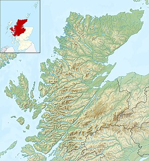
Eilean Hoan is an island in Loch Eriboll in Sutherland on the north coast of Scotland. It is about 28 hectares in extent and the highest point is 25 metres (82 ft) above sea level. Its name is of Gaelic and Old Norse derivation and means "haven island".

Kaminagaya Station is an above-ground metro station located in Kōnan-ku, Yokohama, Kanagawa, Japan operated by the Yokohama Municipal Subway’s Blue Line. It is 11.0 kilometers from the terminus of the Blue Line at Shōnandai Station.

Forte de São Fernando is a fort in the Azores. It is located in Angra do Heroísmo, on the island of Terceira.
Oued El Barad is a town and commune in Sétif Province in north-eastern Algeria.
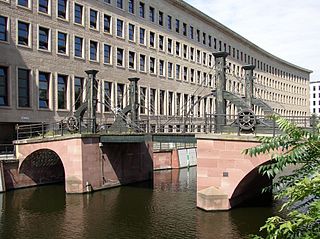
The Jungfern Bridge is a bridge in Berlin. It is the oldest bridge in Berlin. There have been nine predecessors on its site in Berlin-Mitte, spanning the Spree arm Kupfergraben and linking Friedrichsgracht to Oberwasserstraße.
Palais des sports de Marseille is a multi-purpose arena, located in Marseille, France. The seating capacity of the arena varies, 5,800 people and it was opened in 1988.

Sexaginta Prista Bay is the 6.5 km wide bay indenting for 4 km Oscar II Coast in Graham Land southwest of Delusion Point and northeast of Radovene Point. It is part of Exasperation Inlet, formed as a result of the break-up of Larsen Ice Shelf in the area and the retreat of Mapple Glacier in the early 21st century. The feature is named after the ancient Roman town of Sexaginta Prista in Northeastern Bulgaria.

Churicheni Island is the ice-free island in the Onogur group off the northwest coast of Robert Island in the South Shetland Islands, Antarctica extending 230 m by 140 m. It is separated from Robert Island by a 100 m wide passage.
Gоlemo Mramorani is a former village in Municipality of Dolneni.
Flor del Rio is a census-designated place (CDP) in Starr County, Texas, United States. It is a new CDP formed from part of the Los Alvarez CDP prior to the 2010 census with a population of 122.