
Poole is a coastal town and seaport on the south coast of England in the Bournemouth, Christchurch and Poole unitary authority area in Dorset, England. The town is 21 miles (34 km) east of Dorchester and adjoins Bournemouth to the east. Since 1 April 2019, the local authority is Bournemouth, Christchurch and Poole Council. The town had an estimated population of 151,500 making it the second-largest town in the ceremonial county of Dorset. Together with Bournemouth and Christchurch, the conurbation has a total population of nearly 400,000.
Old Orchard Beach is a resort town in York County, Maine, United States. The population was 8,960 at the 2020 census. It is part of the Portland−South Portland−Biddeford, Maine Metropolitan Statistical Area.

Studland is a village and civil parish on the Isle of Purbeck in Dorset, England. The village is located about 2 miles (3.2 km) north of the town of Swanage, over a steep chalk ridge, and 3 miles (4.8 km) south of the South East Dorset conurbation at Sandbanks, from which it is separated by Poole Harbour. The parish includes Brownsea Island within the harbour. In the 2011 census the parish had 182 households and a population of 425, though many of the houses in the village are holiday homes, second homes, or guest houses, and the village's population varies depending upon the season.

The Jersey Shore is the coastal region of the U.S. state of New Jersey. Geographically, the term encompasses about 141 miles (227 km) of oceanfront bordering the Atlantic Ocean, from Perth Amboy in the north to Cape May Point in the south. The region includes Middlesex, Monmouth, Ocean, Atlantic, and Cape May counties, which are in the central and southern parts of the state. Located in the center of the Northeast Megalopolis, the northern half of the shore region is part of the New York metropolitan area, while the southern half of the shore region is part of the Philadelphia metropolitan area, also known as the Delaware Valley. The Jersey Shore hosts the highest concentration of oceanside boardwalks in the United States.
Huntington Park is a park located in Newport News, Virginia, US. It offers a beach, two fishing piers, gardens, tennis, and museums. It is run by the Newport News Department of Parks, Recreation and Tourism. It was formed through a 1924 donation to the city of Newport News by Henry E. Huntington.
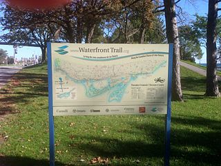
Stretching over 3600 km from Prince Township, west of Sault Ste. Marie, to the Quebec border, the Great Lakes Waterfront Trail is a signed route of interconnecting roads and off-road trails joining over 150 communities and First Nations along the Canadian shores of the Great Lakes and St. Lawrence River. A celebration of nature and culture, the Great Lakes Waterfront Trail is part of a strategy to protect and connect people to the largest group of freshwater lakes on earth. It is a legacy project of the Waterfront Regeneration Trust, a charity, and its community partners. Through Toronto, the trail is called the Martin Goodman Trail. The Waterfront Trail is also used by commuters in parts of Southern Ontario.

Oak Street Beach is located on North Lake Shore Drive in Chicago, Illinois, on the shore of Lake Michigan. One of a series of Chicago beaches, the Chicago Park District defines Oak Street Beach as the area from approximately 1550 North Lake Shore Drive to 500 North Lake Shore Drive, excluding Ohio Street Beach, the South Ledge, a concrete path running from Ohio Street beach to the Oak Street Curve, Oak Street Beachstro Restaurant, Oak Street Beach proper, the North Ledge, and a concrete path running from Oak Street Beach to North Avenue Beach.

Lake railway station is a station on the Isle of Wight serving the village of Lake, situated in a quiet residential area not far from Lake Cliff Gardens and the beach at Sandown Bay. Until the construction of an interchange station with the Isle of Wight Steam Railway at Smallbrook Junction in 1991, this station was the newest on the island having opened by British Rail in 1987. The Station is formed of a single platform with a shelter.

The Redondo Beach pier is located in Redondo Beach, California and stretches out into the Pacific Ocean. The pier has been rebuilt and altered by storms and redevelopments. Its official name is "Municipal Pier," and it has also been called the "Endless Pier".

William Randolph Hearst Memorial State Beach is located near the historic town of San Simeon along California State Route 1, in San Luis Obispo County, California, United States. It is named for newspaper magnate William Randolph Hearst (1863–1951), whose family is closely associated with the area.

The Palace Pier is the site of Palace Place and Palace Pier, two cruciform condominium towers tied for the 45th-tallest building in Toronto, Ontario, Canada. They are located at 2045 Lake Shore Boulevard West and 1 Palace Pier Court in the Humber Bay neighbourhood in the former city of Etobicoke.

Victoria Beach is a rural municipality (RM) in the Eastman Region of Manitoba, Canada, located on the southeastern shores of Lake Winnipeg, approximately 100 kilometres (62 mi) north of Winnipeg.
Ham Common is a Local Nature Reserve at Hamworthy, near Poole, Dorset. Located on the north west shores of Poole Harbour, it is predominantly a heathland site but includes many other habitats including waste ground, mixed woodland, and a freshwater lake. Parking for the site can be found at Hamworthy Beach with access to the waterside for kayaking etc, or above the common from Napier Road. Easy walking access from Haven Rockley Holiday Park.

Virginia Beach Oceanfront refers to the three mile (4.8 km) long boardwalk area in South East Virginia Beach on the Atlantic Coast. It is located North of the Rudee Inlet Bridge and includes the boardwalk itself, Atlantic Avenue, and Pacific Avenue. Virginia Beach is a resort city, and the Oceanfront is a primary tourist attraction. The boardwalk, substantially updated in 1988, is a concrete path linking forty hotels and other attractions via pedestrian walkway and separated bike path -- which in turn connects to nearby trails and surface streets.

Dorset is a county located in the middle of the south coast of England. It lies between the latitudes 50.512°N and 51.081°N and the longitudes 1.682°W and 2.958°W, and occupies an area of 2,653 km2. It spans 90 kilometres (56 mi) from east to west and 63 kilometres (39 mi) from north to south.

The Jurassic Skyline tower was an observation tower on Weymouth Pier in Weymouth, Dorset, England. It was situated next to Weymouth Beach and the Weymouth Pavilion, where it overlooked Weymouth town, the beach, the Pavilion, the Old Harbour, Nothe Gardens, the Nothe Fort, and Portland Harbour. It opened on 22 June 2012.

The English River Dene Nation is a Dene First Nation band government in Patuanak, Saskatchewan, Canada. Their reserve is in the northern section of the province. Its territories are in the boreal forest of the Canadian Shield. This First Nation is a member of the Meadow Lake Tribal Council (MLTC).

King's Pier is a 17th-century stone shipping quay, located on the Isle of Portland, Dorset, England; part of the Jurassic Coast. It is found at the boundary point of the land owned by Portland Port Ltd, on the east side of the island within the area of East Weares. To the north of the pier is Balaclava Bay, whilst further south along the coastline are the remains of Folly Pier and Folly Pier Waterworks, East Weare Rifle Range, the two Salt Pans, Little Beach and Durdle Pier respectively. When active, King's Pier was one of the most important stone shipping pier sites.
