Related Research Articles

Utcubamba, in Quechua Utkhupampa, is one of seven provinces of the Amazonas Region, Peru. It was created by Law#-23843 on May 30, 1984. Its capital is Bagua Grande and its principal attraction is the Tourist Corridor of Utcubamba where the valley becomes notably closer forming "the canyon of Utcubamba". These conditions modify the climate in a substantial way and create a radical ecological shift. The area is fresh and fragrant and the orchids that are bountiful are unique in the world. Notably picturesque cascades are observed in the rocky vertical walls that the river has created. There are hot springs a few meters from El Ingenio bridge.

Choquequirao is an Incan site in southern Peru, similar in structure and architecture to Machu Picchu. The ruins are buildings and terraces at levels above and below Sunch'u Pata, the truncated hill top. The hilltop was anciently leveled and ringed with stones to create a 30 by 50 m platform.

Raqch'i (Quechua) is an Inca archaeological site in Peru located in the Cusco Region, Canchis Province, San Pedro District, near the populated place Raqch'i. It is 3480 meters above sea level and 110 kilometers from the city of Cuzco. It also known as the Temple of Wiracocha, one of its constituents. Both lie along the Vilcanota River. The site has experienced a recent increase in tourism in recent years, with 83,334 visitors to the site in 2006, up from 8,183 in 2000 and 452 in 1996.
Wamanrasu is a mountain in the Chunta mountain range in the Andes of Peru, about 5,304 metres (17,402 ft) high. It is located in the Huancavelica Region, Castrovirreyna Province, Santa Ana District and in the Huancavelica Province, Huancavelica District. Wamanrasu lies northeast of the mountain Antarasu and northwest of the mountain Qarwarasu (Carhuarazo) of the Huancavelica Region.
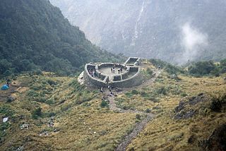
Runkuraqay or Runku Raqay is an archaeological site on a mountain of the same name in Peru located in the Cusco Region, Urubamba Province, Machupicchu District. It is situated southeast of the archaeological site Machu Picchu and south of the Vilcanota river. The ruins lie on the southern slope of the mountain Runkuraqay near the Runkuraqay pass, northeast of the archaeological site Sayacmarca and southeast of the site Qunchamarka.
Choquetacarpo is a 5,520 metres (18,110 ft) high mountain in the Vilcabamba mountain range in the Andes of Peru. It is located in the Cusco Region, La Convención Province, in the districts Santa Teresa and Vilcabamba. Choquetacarpo lies northwest of the Pumasillo peak. The little river Moyoc (Muyuq) originates east of the mountain. It flows to the south as an affluent of the Yanama River.

Kikash or Pampash is a mountain in the Wallanka mountain range in the Andes of Peru, about 5,338 m (17,513 ft)) high. It is located in the Ancash Region, Bolognesi Province, Aquia District. It is situated southwest of the main range in a small subrange called Waman Wiqi. There is a small lake named Waman Wiqi southeast of Kikash. The stream Pampash originates on the west side of the mountain, flowing west to the Patiwillka River.
Coisopacana is a mountain in the Vilcabamba mountain range in the Andes of Peru, about 5,176 metres (16,982 ft) high. It is located in the Cusco Region, La Convención Province, Vilcabamba District. Coisopacana lies southwest of Pumasillo, southeast of Panta and north of the Apurimac River.
Aqupallqa is a mountain in the Cordillera Central in the Andes of Peru, about 5,445 metres (17,864 ft) high. It is situated in the Lima Region, Yauyos Province, Tanta District. Aqupallqa lies north of the mountain Wayna Qutuni and the lake Tikllaqucha and northwest of the mountain Qutuni.

Pillku Urqu, also known as Pikul, Piqul or Wayna Piqul, is a 4,448-metre-high (14,593 ft) mountain in the Andes of Peru, near the city of Cusco. It is situated in the Cusco Region, Calca Province, Taray District, and in the Cusco Province, San Jerónimo District, north of San Jerónimo.

Muyu Urqu is an archaeological site and a prominent hill in Peru. It is situated in the Cusco Region, Cusco Province, Santiago District, east of the mountain Araway Qhata, at the right bank of Watanay River. The mountain with the archaeological remains is about 3,400 metres (11,155 ft) high.

Wayna Tawqaray is an archaeological site in Peru. It is located in the Cusco Region, Cusco Province, San Sebastián District, about 5 km southeast of the center of Cusco. Wayna Tawqaray is situated at a height of about 3,600 metres (11,811 ft) on the slope of the mountain Tawqaray (Taucaray). The mountain with the archaeological remains lies southeast of the mountain Araway Qhata and the hill Muyu Urqu, above the river Watanay.

Llamuqa is a mountain with archaeological remains in the Andes of Peru, about 4,794 metres (15,728 ft) high. It is situated in the Arequipa Region, La Unión Province, Huaynacotas District.
Purunllacta or Purum Llacta (Quechua purum, purun savage, wild / wasteland, llaqta place is an archaeological site of the Chachapoya culture in Peru. It is situated in the Amazonas Region, Chachapoyas Province, Cheto District, on the mountain of the same name. It lies northeast and near the archaeological site of Purunllacta of the Soloco District.

Huaca Huallamarca also known as Huaca Pan de Azúcar, is an archaeological site in Peru. It is located in the district of San Isidro, in the city of Lima.
Parorjo is a mountain in the Urubamba mountain range in the Andes of Peru. It is situated in the Cusco Region, Calca Province, Lares District. Its summit is 4,891 m (16,047 ft) high. Parorjo is situated at the Lares trek north of Chicón and Sirihuani and west of Pucaorjo. One of the nearest populated places is Quishuarani. There is a small lake at its feet named Parococha.
Jatuncucho is a mountain in the Vilcanota mountain range in the Andes of Peru, about 5,400 metres (17,717 ft) high. It is situated in the Cusco Region, Canchis Province, San Pablo District, in the Puno Region, Carabaya Province, Corani District, and in the Melgar Province, Nuñoa District. Jatuncucho lies between Pomanota in the north-west and Jonorana in the east and north-east of the mountain Cochacucho.
Qusqu Qhawarina is a mountain in the Andes of Peru, about 5,217.9 metres (17,119 ft) high. It is located in the Cusco Region, Canchis Province, Checacupe District. Qusqu Qhawarina lies south of a lake named Waka Quta.

Canchacanchajasa is a 4,987-metre-high (16,362 ft) mountain in the Urubamba mountain range in the Andes of Peru. It is located in the Cusco Region, Calca Province, Calca District, north of the Urubamba River. Canchacanchajasa is situated southeast of Sirihuani, north of Cóndorhuachana and Huamanchoque and southwest of Sahuasiray. It lies in the upper part of the Cancha Cancha valley (kancha kancha) at the Lares trek.

Cuncapata is a mountain in the Vilcanota mountain range in the Andes of Peru, about 5,400 metres (17,717 ft) high. It is located in the Cusco Region, Canchis Province, Pitumarca District. Cuncapata lies southwest of the mountain Jatunñaño Punta, north of the lake Sibinacocha and southeast of Chumpe.
References
- ↑ Teofilo Laime Ajacopa, Diccionario Bilingüe Iskay simipi yuyayk'ancha, La Paz, 2007 (Quechua-Spanish dictionary)
- ↑ Diccionario Quechua - Español - Quechua, Academía Mayor de la Lengua Quechua, Gobierno Regional Cusco, Cusco 2005 (Quechua-Spanish dictionary)
- 1 2 "Cerro Hananhuaca". mincetur. Archived from the original on February 13, 2015. Retrieved March 30, 2014.
| | This Amazonas geography article is a stub. You can help Wikipedia by expanding it. |