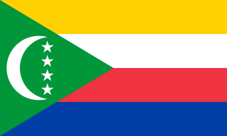
The Comoros, officially the Union of the Comoros, is an island country in the Indian Ocean located at the northern end of the Mozambique Channel off the eastern coast of Africa between northeastern Mozambique, the French region of Mayotte, and northwestern Madagascar. The capital and largest city in Comoros is Moroni. The religion of the majority of the population is Sunni Islam.
This article is about the demographic features of the population of Mayotte, including population density, ethnicity, education level, health of the populace, economic status, religious affiliations and other aspects of the population. Mayotte's population density went from 179 persons per square kilometer in 1985 to 251 per square kilometer in 1991. Its capital, Dzaoudzi, had a population of 5,865 according to the 1985 census; the island's largest town, Mamoudzou, had 12,026 people.

Mayotte is an island of volcanic origin in the northernmost Mozambique Channel, about one-half of the way from northern Madagascar to northern Mozambique. Mayotte is part of the Comoro Islands, and like them is the result of a former hot spot, the oldest of the Comoros archipelago, formed about 7.7 mya. Mayotte has an area of 374 square kilometres, and a coastline of length 185.2 km. Its maritime claims are an exclusive economic zone of 200 nautical miles, and a territorial sea of 12 nm.
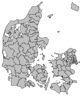
Rødovre Kommune is a municipality in Region Hovedstaden on the island of Zealand in eastern Denmark. Its mayor is Erik Nielsen, a member of the Social Democrats (Socialdemokraterne) political party who hold a majority of seats in the council.
The Complexe de Kawani is a multi-use sports venue in Mamoudzou, Mayotte. Its central feature, the Stade Cavani holds about 5,000 people and serves the Mayotte national football team. The complex also hosts tennis, petanque, athletics, martial arts, and gymnastics.

Tadzin is a village in the administrative district of Gmina Rzgów, within Łódź East County, Łódź Voivodeship, in central Poland. It lies approximately 7 kilometres (4 mi) east of Rzgów and 13 km (8 mi) south-east of the regional capital Łódź.

Saziley National Park is a national park in Mayotte, a French island territory in the Comoro archipelago of the western Indian Ocean. It was established in 1991.
The Baie de Bouéni is a large bay in the south-west of the French island territory of Mayotte, in the Comoro Islands lying at the northern end of the Mozambique Channel between the East African country of Mozambique and Madagascar. It is about 5 km wide at its mouth, and 10 km in length.
The canton of Bandraboua is an administrative division of Mayotte, an overseas department and region of France. Its borders were modified at the French canton reorganisation which came into effect in March 2015. Its seat is in Bandraboua.
The canton of Bouéni is an administrative division of Mayotte, an overseas department and region of France. Its borders were modified at the French canton reorganisation which came into effect in March 2015. Its seat is in Bouéni.
The canton of Dembeni is an administrative division of Mayotte, an overseas department and region of France. Its borders were modified at the French canton reorganisation which came into effect in March 2015. Its seat is in Dembeni.
The canton of Dzaoudzi is an administrative division of Mayotte, an overseas department and region of France. Its borders were not modified at the French canton reorganisation which came into effect in March 2015. Its seat is in Dzaoudzi.
The canton of Koungou is an administrative division of Mayotte, an overseas department and region of France. Its borders were modified at the French canton reorganisation which came into effect in March 2015. Its seat is in Koungou.
The cantons of Mamoudzou are administrative divisions of Mayotte, an overseas department and region of France. Since the French canton reorganisation which came into effect in March 2015, the city of Mamoudzou is subdivided into 3 cantons. Their seat is in Mamoudzou.
The canton of Mtsamboro is an administrative division of Mayotte, an overseas department and region of France. Its borders were modified at the French canton reorganisation which came into effect in March 2015. Its seat is in Mtsamboro.
The canton of Ouangani is an administrative division of Mayotte, an overseas department and region of France. Its borders were modified at the French canton reorganisation which came into effect in March 2015. Its seat is in Ouangani.
The canton of Pamandzi is an administrative division of Mayotte, an overseas department and region of France. Its borders were not modified at the French canton reorganisation which came into effect in March 2015. Its seat is in Pamandzi.
The canton of Sada is an administrative division of Mayotte, an overseas department and region of France. Its borders were modified at the French canton reorganisation which came into effect in March 2015. Its seat is in Sada.
The canton of Tsingoni is an administrative division of Mayotte, an overseas department and region of France. Its borders were modified at the French canton reorganisation which came into effect in March 2015. Its seat is in Tsingoni.


