
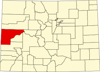
Mesa County is a county located in the U.S. state of Colorado. As of the 2020 census, the population was 155,703. The county seat and most populous municipality is Grand Junction. The county was named for the many large mesas in the area, including the Grand Mesa, which is the largest flat-topped mountain in the world.

Dolores is a Statutory Town located in Montezuma County, Colorado, United States. The town population was 885 at the 2020 United States Census.
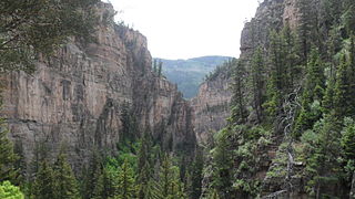
Glenwood Canyon is a rugged scenic 12.5 mi (20 km) canyon in western Colorado in the United States. Its walls climb as high as 1,300 feet (400 m) above the Colorado River. It is the largest such canyon on the Upper Colorado. The canyon, which has historically provided the routes of railroads and highways through western Colorado, currently furnishes the routes of Interstate 70 and the Union Pacific's Central Corridor between Denver and Grand Junction.
De Beque Canyon is a narrow canyon on the Colorado River in western Colorado in the United States. It is approximately 15 miles (24 km) long, located on the river downstream from the town of De Beque, in eastern Mesa County. The canyon forms a narrow passage where the river passes along the western end of the Grand Mesa. At its lower end, the canyon opens out on the eastern end of the Grand Valley at the town of Palisade, approximately 10 miles (16 km) east of Grand Junction. Interstate 70 follows the river through the canyon.

The Grand Mesa is a large mesa in western Colorado in the United States. It is the largest flat-topped mountain in the world. It has an area of about 500 square miles (1,300 km2) and stretches for about 40 miles (60 km) east of Grand Junction between the Colorado River and the Gunnison River, its tributary to the south. The north side of the mesa is drained largely by Plateau Creek, a smaller tributary of the Colorado. The west side is drained largely by Kannah Creek, which is received to the west by the lower Gunnison River. The mesa rises about 6,000 feet (1,800 m) above the surrounding river valleys, including the Grand Valley to the west, reaching an elevation of about 11,000 feet (3,400 m). Much of the mesa is within Grand Mesa National Forest. Over 300 lakes, including many reservoirs created and used for drinking and irrigation water, are scattered along the top of the formation. The Grand Mesa is flat in some areas, but quite rugged in others.

Colorado Christian University (CCU) is a private Christian university in Lakewood, Colorado. CCU was founded by Clifton Fowler in 1914 as the Denver Bible Institute.
Colorado Mesa University Tech is a division of Colorado Mesa University in Grand Junction, Colorado specializing in vocational studies. Students take core curriculum courses at CMU's main campus, but complete their program of study at CMU Tech. Associate degrees from CMU Tech are awarded by Colorado Mesa University.

Carpenter is an extinct coal mining town located in Mesa County, Colorado, United States, twelve miles northeast of Grand Junction at the end of an extension to 27¼ Road. The townsite is located at 39.1944°N 108.4733°W, at an elevation of 5,808 feet (1,770 m). The Carpenter post office operated from June 11, 1890, only until August 3, 1891.

KBKL is a radio station serving Grand Junction, Colorado, and vicinity with a classic hits format. This station is under the ownership of Townsquare Media.
KCIC is a radio station broadcasting a religious radio format. Licensed to Grand Junction, Colorado, United States, it serves the Grand Junction area. The station is currently owned by Pear Park Baptist Schools.
KLFV is a radio station in Grand Junction, Colorado. The station broadcasts a contemporary Christian format from the K-Love radio network; the station and network are owned by the Educational Media Foundation.
KMXY is a radio station broadcasting a Hot Adult Contemporary format. Licensed to serve Grand Junction, Colorado, United States, it serves the Grand Junction area. The station is currently owned by Townsquare Media, through licensee Townsquare License, LLC.

Grand Valley is an American Viticultural Area (AVA) within Mesa County, Colorado located in a high-altitude river valley surrounding the county seat of Grand Junction and stretching 24 miles (39 km) east-west between the municipalities of Palisade and Fruita. It lies approximately 200 miles (320 km) west-southwest of Denver along Interstate 70. The river valley encompasses 75,990 acres (118.73 sq mi), with an average elevation between 4,000 and 5,000 feet (1,200–1,500 m) above sea level and is defined by an irrigated agricultural area served by canals in the Grand Valley of the Colorado River. Grand Valley AVA was established by the Bureau of Alcohol, Tobacco and Firearms (ATF) on December 26, 1991, upon the petition submitted by Mr. James Seewald of Vintage Colorado Cellars Winery, and the first viticultural area registered in the Centennial State. In 2001, the smaller West Elks AVA, located southeast of Grand Valley, became the state's second federally-designated AVA.
The Ute meridian, also known as the Grand River meridian, was established in 1880 and is a principal meridian of Colorado. The initial point lies inside the boundaries of Grand Junction Regional Airport, Grand Junction, Colorado.
This is a list of the National Register of Historic Places listings in Mesa County, Colorado.

This is a list of the National Register of Historic Places listings in Rio Blanco County, Colorado.

Cross Orchards Historic Site is a living history museum located in Grand Junction, Colorado. It is part of the Museums of Western Colorado. It was added to the National Register of Historic Places in 1980. The Orchards are known for showing how life was on an orchard at the turn of the twentieth century and is considered living history as it is still worked and cultivated regularly. It features a workers' bunkhouse, blacksmith shop, an apple orchard, and a collection of vintage farming equipment. The site includes farm equipment, implements and tools, a period farmhouse, a recreated train depot and Uintah Railway exhibit with railroad cars, an engine and caboose, and historic horse-drawn road-building equipment. It is also home to the largest collection of Uintah Railway cars on the Colorado western slope.
Climax Uranium Mill is a decommissioned uranium mill near Grand Junction, CO.
Country Jam is an annual music festival in the Western Slope of Colorado, United States, which started in 1992. It is the largest country music and camping festival in the state.
Frostline Kits was a Colorado-based company that produced sew-it-yourself kits for outdoor gear including clothing and tents.
