Hanskühnenburg

Last updated
Mountain hut and tower HanskuehnenburgTurm.jpg
Mountain hut and tower
Hanskuhnenburg Rocks HansKuehnenburgFelsen.jpg
Hanskühnenburg Rocks
The crag from the south HanskuehnenburgKlippenSued.jpg
The crag from the south
The crag from the west HanskuehnenburgOst.jpg
The crag from the west
Information boards by the hut HanskuehnenburgInfo.jpg
Information boards by the hut

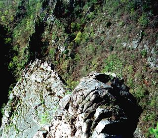
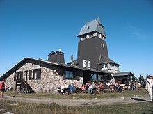
The Hanskühnenburg is a mountain hut (German : Bergbaude) in the Harz mountains. It is located at a height of 811 m (2,661 ft) above sea level in fields known as Auf dem Acker, or simply Acker, in the middle of the Harz National Park and has its own observation tower. Its name comes from the legendary Hanskühnenburg Crag (Hanskühnenburg Klippe) 300 metres to the northwest, which was visited on 14 August 1784 by Johann Wolfgang von Goethe. Opposite the tower are the Hanskühnenburg Rocks (Hanskühnenburg Felsen) that are relatively small by comparison with the Klippe. A bronze plaque was mounted on these rocks in 1999 to commemorate Goethe's visit. In front of the Hanskühnenburg Rocks, a monument was erected in 1924 to Albert Leo Schlageter. It has since fallen over and is rather weathered.

Mountain hut building located in the mountains

A mountain hut is a building located high in the mountains, generally accessible only by foot, intended to provide food and shelter to mountaineers, climbers and hikers. Mountain huts are usually operated by an Alpine Club or some organisation dedicated to hiking or mountain recreation.

German language West Germanic language

German is a West Germanic language that is mainly spoken in Central Europe. It is the most widely spoken and official or co-official language in Germany, Austria, Switzerland, South Tyrol (Italy), the German-speaking Community of Belgium, and Liechtenstein. It is also one of the three official languages of Luxembourg and a co-official language in the Opole Voivodeship in Poland. The languages which are most similar to German are the other members of the West Germanic language branch: Afrikaans, Dutch, English, the Frisian languages, Low German/Low Saxon, Luxembourgish, and Yiddish. There are also strong similarities in vocabulary with Danish, Norwegian and Swedish, although those belong to the North Germanic group. German is the second most widely spoken Germanic language, after English.

Harz National Park national park of Germany

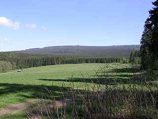
Harz National Park is a nature reserve in the German federal states of Lower Saxony and Saxony-Anhalt. It comprises portions of the western Harz mountain range, extending from Herzberg and Bad Lauterberg at the southern edge to Bad Harzburg and Ilsenburg on the northern slopes. 95 % of the area is covered with forests, mainly with spruce and beech woods, including several bogs, granite rocks and creeks. The park is part of the Natura 2000 network of the European Union.

Contents

History

At the end of the 19th century, the Osterode branch of the Harz Club built the first wooden observation tower and a managed refuge hut on the thickly wooded Acker crest; the hut being opened in 1889. The tower proved unable to cope with the weather conditions and, by 1912, had become so damaged that it had to be torn down. One year later, the Hanover branch began the construction of a stone tower on the same spot; it was completed in 1914.

Harz Club alpine club, voluntary association

The Harz Club is club dedicated to maintaining the traditions of the Harz mountains in Germany and looking after the walking trails in the Harz. It was founded in 1886 in Seesen and, today, has about 16,000 members in some 90 branches.

Observation tower structure used to view events from a long distance

An observation tower is a structure used to view events from a long distance and to create a full 360 degree range of vision to conduct the long distance observations. They are usually at least 20 metres (66 ft) tall and made from stone, iron, and wood. Many modern towers are also used as TV towers, restaurants, or churches. The towers first appeared in Germany at the end of the 18th century, and their numbers steadily increased, especially after the invention of the lift.

The First World War brought tourism to a standstill and the hut which was being managed as an inn, was closed, not least because it was a long way from any other settlements. In 1922, the guest house opened again until the Second World War broke out.

In 1947, the hut, which had meanwhile become quite dilapidated, re-opened, but had to be closed again in 1957 when the hut and tower were placed out of bounds by the police due to their condition. In 1958 it had been refurbished sufficiently to enable the ban to be lifted again. but the fundamental overhaul that was really required was not carried out. In 1971 the damage to the Hanskühnenburg was once again so serious, that the structure was closed again. After emergency repairs the tower and hut re-opened in 1972.

The Harz Club did not have the necessary means to restore the structure and transferred ownership in 1974 to the district of Osterode, which took on the conversion and upgrade of the Hanskühnenburg. In 1975 this was completed at a cost of 500,000 DM and the operation of the hut started up again.

In 1976, a 13.5 km (8.4 mi) long cross-country skiing trail, the Ackerloipe, was completed and, as a result, the Hanskühnenburg became a popular stop for langlauf skiers.

Cross-country skiing trail

A cross-country skiing trail or loipe is a route that has been laid out, constructed and maintained specifically for cross-country skiing. Trails may extend point-to-point, but are more typically loops for recreational use or for competition. Until the mid-20th Century, trails were tracked by the passage of skiers. More recently, snow groomers set tracks for classic skiing and smooth lanes for skate skiing.

Since the 1960s, the forest on the Acker crest has steadily retreated. At one time, the hut was hidden in thick forest; today, it is visible from a long way off. The tower offers a good all-round view over the mountains of the Upper Harz. It is also the only spot from where the two former centres of the Upper Harz mining industry, Clausthal and Sankt Andreasberg, can be seen at the same time.

Upper Harz western and higher part of the Harz mountain range in central Germany

The Upper Harz refers to the northwestern and higher part of the Harz mountain range in Germany. The exact boundaries of this geographical region may be defined differently depending on the context. In its traditional sense, the term Upper Harz covers the area of the seven historical mining towns (Bergstädte) - Clausthal, Zellerfeld, Andreasberg, Altenau, Lautenthal, Wildemann and Grund - in the present-day German federal state of Lower Saxony. Orographically, it comprises the Harz catchment areas of the Söse, Innerste and Grane, Oker and Abzucht mountain streams, all part of the larger Weser watershed.

Sankt Andreasberg Stadtteil of Braunlage in Lower Saxony, Germany

Sankt Andreasberg is a former town in the district of Goslar, in Lower Saxony, Germany. Since 1 November 2011, it is part of the town Braunlage. It is situated in the Harz, approximately 7 km west of Braunlage proper, and 20 km east of Osterode am Harz.

Walking trails

The Hanskühnenburg may be reached from all directions on numerous walking trails. There are longer walks from Osterode via the town forest (Stadtwald) and crest path (Kammweg) or along the Söse Reservoir. From Herzberg a path climbs from Lonau through the valleys of the Großer Lonau (metalled road) and the Sieber. The height difference is markedly less on the route from Riefensbeek-Kamschlacken to the hut. The easiest way to get to the hut, however, is from Stieglitzecke on the Harz High Road. Here there is a large car park and a bus stop. From the Stieglitzecke there are two routes to the Hanskühnenburg. The path on the eastern side is a wide walking track with only one steep section shortly before the hut. Considerably better views, especially in the morning, are offered by the path on the west side of the Acker. This path is however very hard going and rather boggy because the rain gutters have not been replaced for some time.

The tower is only accessible when the restaurant is open.

The Hahnskühnenburg is checkpoint no. 144 in the Harzer Wandernadel system, a popular network of walking trails.

Related Research Articles

Lonau is a small village with a population of about 345 situated at an elevation of about 400m in the Harz Mountains of Northern Germany. Besides the clean air and lush forests, it is famous for the capercaillie. It belongs to the city of Herzberg am Harz which is about 4 km to the south. The rivers Große Lonau and Kleine Lonau join here.

Wurmberg (Harz) hill in Germany

At 971 m above sea level (NN) the Wurmberg is the second highest mountain in the Harz and the highest in Lower Saxony (Germany).

Bruchberg mountain

At 927 m above sea level (NN), the Bruchberg in the Upper Harz is the second highest mountain in Lower Saxony and the third highest in the Harz mountains in North Germany. It lies between Altenau and Torfhaus in the middle of the Harz National Park. The Bruchberg is more like a plateau and has no real summit. This plateau is partly covered with trees, but on the sunny southern slopes the trees have largely died as a result of bark beetle infestation. Following this insect destruction, a new natural forest, rich in its variety of species, is now growing in the heart of the Harz National Park.

Schalke (Harz) mountain in Germany

The Schalke is a mountain, 762 m above sea level (NN), in the Upper Harz in the German state of Lower Saxony. It lies in Goslar district north of Clausthal-Zellerfeld and west of Schulenberg.

Söse river in Germany

Söse is a river of Lower Saxony, Germany. It is a right tributary of the river Rhume and 38 kilometres (24 mi) long.

Auf dem Acker mountain

Auf dem Acker is a mountain ridge up to 865.1 metres high, which is located in the southwestern part of the Harz mountains in Lower Saxony (Germany).

Großer Knollen mountain in the Harz, Germany

The Großer Knollen is a 687.4-metre-high (2,255 ft) mountain in the southwestern part of the Harz in Lower Saxony, Germany.

Roßtrappe

The Roßtrappe is a 403-metre-high (1,322 ft) granite crag in the Harz mountains of central Germany.

Harzer Hexenstieg Hiking trail in the Harz Mountains

The Harz Witches' Trail is a footpath, just under 100 km long, in Germany that runs from Osterode through the Harz mountains and over its highest peak, the Brocken, to Thale. It is a project by the Harz Transport Association and Harz Club and is part of the system of trails known as the Harzer Wandernadel.

Romkerhall

Romkerhall is a popular tourist destination on the River Oker in the Harz Mountains of Germany. There is a public car park here as well as a hotel and restaurant opposite the Romkerhall Waterfall. Romkerhall lies within the unincorporated area of Harz in the Lower Saxon county of Goslar in the Harz Mountains. The hotel and waterfall form a small tourist attraction which is marketed as the "Kingdom of Romkerhall - the smallest kingdom in the world!"

Bode Gorge

The Bode Gorge is a 10 kilometres (6.2 mi) long ravine that forms part of the Bode valley between Treseburg and Thale in the Harz Mountains of central Germany. The German term, Bodetal, is also used in a wider sense to refer to the valleys of the Warme and Kalte Bode rivers that feed the River Bode.

Kahle Klippe

The Kahle Klippe is a rock formation in the High Harz in central Germany on the eastern slope of the Brocken above the valley of the Ecker.

Rabenklippe

The Rabenklippe is a granite rock formation in the Harz National Park. The name means "Raven Crag" and is very apt as ravens live in the vicinity.

Braakberg mountain in the Harz, Germany

The Braakberg is a 645.5 metre high mountain in the Harz in central Germany that lies in the unincorporated area of Harz in the district of Göttingen in the state of Lower Saxony.

Goethe Way is the name given to a number of footpaths or trails that run through various regions in Germany and the Alps as well as a railway station on the Brocken Railway. They are all named after the German poet, Johann Wolfgang von Goethe.

The Eckerloch is a forested mountain valley, 845 metres above sea level near the village of Schierke in the Harz Mountains of central Germany.

Schindelkopf mountain in the Harz, Germany

The Schindelkopf in the Harz Mountains of central Germany is a southwestern outlier of the mountain ridge known as Auf dem Acker. It is located near the town of Osterode am Harz within the unincorporated area of Harz which is in the district of Göttingen in the state of Lower Saxony.

Jagdkopf (Zorge) mountain next to Zorge, Harz, Germany

The Jagdkopf a hill, 603.1 m above sea level (NN) high, in the Harz Mountains of Germany. It is located between the villages of Wieda and Zorge in the unincorporated area of Harz in the district of Göttingen in the state of Lower Saxony.

References

    51°43′41″N10°24′11″E / 51.72806°N 10.40306°E / 51.72806; 10.40306