Harzer Wandernadel

Last updated
Josephshohe checkpoint on the Harz Hikers network Stempelstelle am Josephskreuz 20210914 HOF06147 RAW-Export 20220428002500.jpg
Josephshöhe checkpoint on the Harz Hikers network
Checkpoint at the Konigsburg Stempelstelle Harzer Wandernadel.jpg
Checkpoint at the Königsburg

The Harzer Wandernadel is a system of hiking awards in the Harz mountains in central Germany. Hikers (or mountain bikers) can earn awards at different levels of challenge by walking to the various checkpoints in the network and stamping their passbooks to record the visit. With 222 checkpoints in three federal states and across five districts in the Harz and with membership in five figures, the system has gained a following Germany-wide.

Contents

Purpose

The idea of the Wandernadel (literally "hiking needle/pin" --> "hiking badge") is to give those holidaying in the Harz a worthwhile goal to achieve and encourage them to stay for longer or return. It also aims to encourage those who live in the local area to go hiking and improve their fitness.

In addition the system helps tourists and locals to get to know the many different sights and hiking trails in the Harz. To that end, checkpoints have been located at scenic viewing points, places of geological or botanical, culturalbor historical or interest.With a few exceptions, the checkpoints can only be reached on foot or bicycle.

Hiking badge system

The hiking badges Harzer Wandernadeln.jpg
The hiking badges

Harz hiking badges are awarded at several levels depending on the number of checkpoints reached (verified by stamping a pass book):

The awards may be earned over any period of time; there is no time limit within which the stamps have to be collected.

In addition there are special themed hiking badges that may be earned. For example there is one for collecting 11 stamps on checkpoints located on the Harzer Hexenstieg the "Harz Witch's Path". Others include a Goethe Way (Goetheweg) badge and an Inner German Border badge.

It is also possible, in addition to collecting all 222 stamps, to collect several additional special stamps that are recorded at the end of a walking pass. These special stamps are only collector's items and do not count towards any award.

Process for getting a hiking badge

Checkpoint at the Bremen Hut Bremer Hutte am Brocken.jpg
Checkpoint at the Bremen Hut

Before visiting checkpoints and starting to collect stamps, the hiker first needs to buy a hiking pass book (Wanderpass); these can be obtained cheaply online or in the tourist and spa facilities in the towns and villages of the Harz, in participating pubs within the network and in some bookshops. It is also worthwhile buying a set of 3 maps on which the checkpoints are marked, although this information can be found in other ways, including the organiser's website. The website first published its English pages in 2012 with the support of the British garrison in Hohne.

The pass must be stamped at each checkpoint. If the stamp is missing or damaged, a code number can be noted down as an alternative. This ensures that vandalism should not prevent hikers from collecting points towards their badges.

On gaining the requisite number of stamps, the pass is handed in again at a counter and the badges can be bought at little cost after the pass has been checked. The Foreman (Steiger) and Emperor (Kaiser) badges can only be obtained from the Harzer Wandernadel main office in Blankenburg, which is only open Monday to Friday during working hours.

Features

The Harz hiking badge is significantly different from many other hiking badge systems. For example, there are hardly any other places where there is a system with as many as 222 control points crossing state and district boundaries. In addition the system is relatively well protected from vandalism and can be set up anywhere on the terrain, whilst with other systems the checkpoints are at restaurants, shops, etc., and can only be used during opening hours.

Unlike other hiking badge projects, the hassle of enrolling as a 'customer' is avoided, because the stamps may be collected freely without needing to supply anyone with a telephone number or address.

History

The initiator and operator is the Gesund älter werden im Harz ("Aging healthily in the Harz") with its head office in Blankenburg, which is supported by various public institutions. The first checkpoints were set up in 2006; since 2007 the current system of 222 control points has been available. There are no plans to extend it, however the checkpoints are sometimes relocated to different places in the Harz.

Resonance

The system soon gained extraordinary popularity, as can clearly be seen from the number of walkers stamping their passes at the control points. In 2009 alone about 10,000 hiking passes were sold. [1] It is also noteworthy that in each year there has been a three-figure number of walkers that have achieved the highest award, the "Harz Hiking Emperor". (As the control points are spread across a 110 km long and 30 - 40 km wide range of low mountains, covering all of them may take a total of several weeks spent on the trails and travelling to the trails.)

Locations

Some of examples of checkpoints in the Harzer Wandernadel are listed below:

Checkpoint No.NameDescriptionLocation
1Eckertalsperre (Staumauer)Barrier of the Ecker Dam 4 km SE of Bad Harzburg
5FroschfelsenThe Froschfelsen rock formation that looks like a frog2 km SW of Ilsenburg
9BrockenThe Brocken, the highest peak in the HarzBrocken summit
17TrudensteinThe Trudenstein rock formation2.5 km NE of Schierke
80Burgruine Regenstein Regenstein Castle 2 km N of Blankenburg
98Ruine Hohnstein Hohnstein Castle 1 km NNE of Neustadt/Harz
101Einhornhöhle Unicorn Cave, a popular show cavenear Scharzfeld
122Kreuz des Deutschen OstensAn Ostlandkreuz, a cross in memory of former eastern German landsAbove Bad Harzburg to the SE

List of checkpoints

The following is a list of all the checkpoints as at December 2012. They are listed by their German names used by the Harzer Wandernadel.

1 to 60

61 to 120

121 to 180

181 to 222

Related Research Articles

<span class="mw-page-title-main">Königsburg</span> Ruined medieval castle

The Königsburg is a ruined medieval castle southeast of Königshütte, a village in the borough of Oberharz am Brocken, in Harz district in the German state of Saxony-Anhalt.

<span class="mw-page-title-main">Elbingerode</span> Ortsteil of Oberharz am Brocken in Saxony-Anhalt, Germany

Elbingerode is an Ortsteil of Oberharz am Brocken in the Harz district, in the German state of Saxony-Anhalt. The former town was incorporated into the newly established municipality on 1 January 2010.

<span class="mw-page-title-main">Altenbrak</span> Ortsteil of Thale in Saxony-Anhalt, Germany

Altenbrak is a village and a former municipality in the district of Harz, in Saxony-Anhalt, Germany.

<span class="mw-page-title-main">Buntenbock</span>

The small village of Buntenbock lies on the plateau of the Harz mountains in Germany and is part of the mining and university town of Clausthal-Zellerfeld. It is a state-recognised climatic health resort and has accommodation for 200 visitors as well as 700 inhabitants.

<span class="mw-page-title-main">Harzer Hexenstieg</span>

The Harz Witches' Trail is a footpath, just under 100 km long, in Germany that runs from Osterode through the Harz mountains and over its highest peak, the Brocken, to Thale. It is a project by the Harz Transport Association and Harz Club and is part of the system of trails known as the Harzer Wandernadel.

<span class="mw-page-title-main">Hoher Kleef</span> Rock formation in Rübeland, Germany

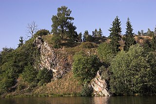
The Hoher Kleef is a rock formation in Rübeland in the district of Harz within the Harz mountains of Germany. It is mainly composed of granite.

<span class="mw-page-title-main">Trautenstein</span> Ortsteil of Oberharz am Brocken in Saxony-Anhalt, Germany

Trautenstein is a village in the borough of Oberharz am Brocken in the district of Harz in the German state of Saxony-Anhalt. Trautenstein has 493 inhabitants as of 1 January 2010. Formerly an independent municipality, it was merged into the town Hasselfelde in 2002, which was merged into Oberharz am Brocken in 2010.

The Luisenburg was a small palace that existed from 1728 to 1945 near Blankenburg (Harz) in central Germany.

<span class="mw-page-title-main">Trageburg</span>

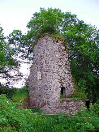
The Trageburg is a ruined castle immediately next to the Rappbode Pre-Dam in the Harz Mountains of Germany. It is located near Trautenstein in the district of Harz in Saxony-Anhalt.

<span class="mw-page-title-main">Bärenbrucher Teich</span>

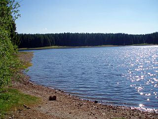
The Bärenbrucher Teich is an historic reservoir in the Harz Mountains of central Germany. It lies east of Buntenbock near Clausthal-Zellerfeld.

<span class="mw-page-title-main">Bremer Teich</span> Dam in Landkreis Harz

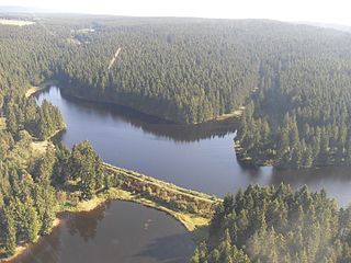
The Bremer Teich is an historic reservoir that lies south of the two villages of Bad Suderode and Gernrode in the Harz Mountains of Germany, and is used as a recreation area. It impounds the Bremer Graben, an artificial channel fed by water from the Bode and the Saale. The water reservoir was built in the 18th century in the Lower Harz (Saxony-Anhalt). It has an area of ca. 4 ha. The pond is located on the Romanesque Road and the North Harz Cycleway.

<span class="mw-page-title-main">Bremen Hut (Ilsenburg)</span>

The Bremen Hut in the Harz Mountains is a refuge hut and shelter in that part of the Harz National Park lying within the borough of Ilsenburg (Harz) in Harz district in the German state of Saxony-Anhalt.

<span class="mw-page-title-main">Ilse valley</span>

The Ilse valley is the ravine of the Ilse stream in the northern boundary of the Harz mountain range in Germany. Part of the Harz National Park, it runs from the town of Ilsenburg at the foot of the mountain range up to the source region near the summit of the Brocken massif, the highest mountain of the range. The scenic valley is a popular hiking area.

<span class="mw-page-title-main">Ilsestein</span> Prominent granite rock formation near Ilsenburg, Harz, Germany

The Ilsestein is a prominent granite rock formation near the town of Ilsenburg in the Harz mountains of central Germany. Offering a scenic view over the Ilse valley to the Brocken massif, the highest mountain of the range, it is today a popular tourist destination.

<span class="mw-page-title-main">Jägersbleeker Teich</span>

The Jägersbleeker Teich in the Harz Mountains of central Germany is a storage pond near the town of Clausthal-Zellerfeld in the county of Goslar in Lower Saxony. It is one of the Upper Harz Ponds that were created for the mining industry.

<span class="mw-page-title-main">Köte</span>

A Köte is the term used in the Harz Mountains of central Germany for a charcoal burner's hut (Köhlerhütte). A Köte was occupied by a charcoal burner in order to look after a nearby wood pile (Kohlenmeiler). The charcoal burner prepared the necessary charcoal for the smelting of ores.

<span class="mw-page-title-main">Bergrat Müller Pond</span> Dam in Harz county, Saxony-Anhalt

The Bergrat Müller Pond, named after a former mining director, Müller, in the Harz mountains of central Germany is a storage pond laid out from 1737 to 1738. It has an area of about 1.3 ha and lies in the forested southern part of the borough of Quedlinburg in the county of Harz in Saxony-Anhalt.

<span class="mw-page-title-main">Stierbergsteich</span> Dam in Harz; counties of Harz and Nordhausen; Saxony-Anhalt and Thuringia

The Stierbergsteich in the Harz Mountains of central Germany is a storage pond near Rothesütte on the boundary of the counties of Harz (Saxony-Anhalt) and Nordhausen (Thuringia).

The Schindelkopf in the Harz Mountains of central Germany is a southwestern outlier of the mountain ridge known as Auf dem Acker (865.1 m). It is located near the town of Osterode am Harz within the unincorporated area of Harz which is in the district of Göttingen in the state of Lower Saxony.

The Jagdkopf a hill, 603.1 m above sea level (NN) high, in the Harz Mountains of Germany. It is located between the villages of Wieda and Zorge in the unincorporated area of Harz in the district of Göttingen in the state of Lower Saxony.

References