Treppenstein

Last updated
View of the Oker valley from the Treppenstein Blick vom Treppenstein.jpg
View of the Oker valley from the Treppenstein

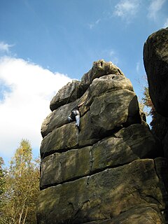
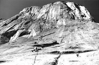
The Treppenstein is a rock formation in the Oker valley in the Harz mountains of central Germany. It lies on the trail from the Romkerhall Waterfall to the Kästeklippen . The rocks consist of granite and have clearly undergone so-called "wool sack weathering" (Wollsackverwitterung). [1]

Germany Federal parliamentary republic in central-western Europe

Germany, officially the Federal Republic of Germany, is a country in Central and Western Europe, lying between the Baltic and North Seas to the north, and the Alps to the south. It borders Denmark to the north, Poland and the Czech Republic to the east, Austria and Switzerland to the south, France to the southwest, and Luxembourg, Belgium and the Netherlands to the west.

Kästeklippen cliff in the Harz Mountains

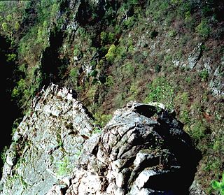
The Kästeklippen, often shortened to Käste, is a rocky tor above the Oker valley in the Upper Harz mountains of central Germany. It lies at a height of 602 m above NN.

Granite A common type of intrusive, felsic, igneous rock with granular structure

Granite is a common type of felsic intrusive igneous rock that is granular and phaneritic in texture. Granites can be predominantly white, pink, or gray in color, depending on their mineralogy. The word "granite" comes from the Latin granum, a grain, in reference to the coarse-grained structure of such a holocrystalline rock. Strictly speaking, granite is an igneous rock with between 20% and 60% quartz by volume, and at least 35% of the total feldspar consisting of alkali feldspar, although commonly the term "granite" is used to refer to a wider range of coarse-grained igneous rocks containing quartz and feldspar.

The Treppenstein is a popular destination and part of the system of checkpoints (no. 117) in the Harzer Wandernadel hiking trail network. The summit has safety railings and may be climbed using steps hacked out of the rock and flights of stairs attached to the rocks. From the summit there is a view towards the west. In addition, part of the rock formation, the Kleine Treppenstein is used for rock climbing. The routes here are rated as Grade VI (UIAA). [2]

Harzer Wandernadel

The Harzer Wandernadel is a system of hiking awards in the Harz mountains in central Germany. The hiker can earn awards at different levels of challenge by walking to the various checkpoints in the network and stamping his or her passbook to record the visit. With 222 checkpoints in three federal states and across five districts in the Harz and with membership in five figures, the system has gained a following Germany-wide.

Rock climbing sport in which participants climb up, down or across natural rock formations or artificial rock walls

Rock climbing is an activity in which participants climb up, down or across natural rock formations or artificial rock walls. The goal is to reach the summit of a formation or the endpoint of a usually pre-defined route without falling. Professional rock climbing competitions have the objectives of either completing the route in the quickest possible time or attaining the farthest point on an increasingly difficult route.

Climbing route path by which a climber reaches the top of a mountain, rock, or ice wall

A climbing route is a path by which a climber reaches the top of a mountain, rock, or ice wall. Routes can vary dramatically in difficulty and grade; once committed to that ascent, it can sometimes be difficult to stop or return. Choice of route can be critically important. Guidebooks, if available, are helpful in providing detailed diagrams and photographs of routes.

Related Research Articles

Mount Everest Earths highest mountain, part of the Himalaya between Nepal and China

Mount Everest, known in Nepali as Sagarmatha (सगरमाथा) and in Tibetan as Chomolungma (ཇོ་མོ་གླང་མ), is Earth's highest mountain above sea level, located in the Mahalangur Himal sub-range of the Himalayas. The international border between Nepal and China runs across its summit point.

Red Rock Canyon National Conservation Area protected area

The Red Rock Canyon National Conservation Area in Nevada is an area managed by the Bureau of Land Management as part of its National Landscape Conservation System, and protected as a National Conservation Area. It is about 15 miles (24 km) west of Las Vegas, and is easily seen from the Las Vegas Strip. More than two million people visit the area each year.

El Capitan rock formation in Yosemite National Park, California

El Capitan is a vertical rock formation in Yosemite National Park, located on the north side of Yosemite Valley, near its western end. The granite monolith is about 3,000 feet (900 m) from base to summit along its tallest face, and is a popular objective for rock climbers.

Pictured Rocks National Lakeshore

Pictured Rocks National Lakeshore is a U.S. National Lakeshore on the shore of Lake Superior in the Upper Peninsula of Michigan, United States. It extends for 42 miles (67 km) along the shore and covers 73,236 acres. The park has extensive views of the hilly shoreline between Munising and Grand Marais in Alger County, Michigan, with picturesque rock formations, waterfalls, and sand dunes.

Tryfan Mountain in Wales

Tryfan is a mountain in the Ogwen Valley, Snowdonia, Wales. It forms part of the Glyderau group, and is one of the most famous and recognisable peaks in Britain, having a classic pointed shape with rugged crags. At 917.5 metres above sea level it is the fifteenth-highest mountain in Wales. The name "Tryfan" is derived from its historical Welsh name of "Tri-faen". "Tri" meaning three and "faen" meaning rocks which makes reference to the 3 rocky humps seen on the mountain's summit. Tryfan was voted Britain’s favourite mountain by Trail magazine.

Vasquez Rocks

Vasquez Rocks Natural Area Park is a 932-acre (377-hectare) park located in the Sierra Pelona Mountains in northern Los Angeles County, California. It is located in the town of Agua Dulce, between the suburbs of Santa Clarita and Palmdale. The area is also visible from the Antelope Valley Freeway.

Goat Rocks mountain in United States of America

Goat Rocks is an extinct stratovolcano in the Cascade Range, located between Mount Rainier and Mount Adams in southern Washington, in the United States. Part of the Cascade Volcanoes, it was formed by the subduction of the Juan de Fuca Plate under the western edge of the North American Plate. The volcano was active from 3.2 million years ago until eruptions ceased between 1 and 0.5 million years ago. Throughout its complex eruptive history, volcanism shifted from silicic explosive eruptions to voluminous, mafic activity.

Old Rag Mountain mountain in United States of America

Old Rag Mountain is a 3,284 feet (1,001 m) mountain near Sperryville in Madison County, Virginia. A part of the Blue Ridge Mountains, the peak is located within Shenandoah National Park and is the most popular hiking destination within the park.

Harrisons Rocks

Harrison's Rocks is a sandstone crag approximately 1.5 kilometres (1 mi) south of the village of Groombridge in the county of East Sussex. The site is a notable example of a periglacial tor landform developed in rocks of the Tunbridge Wells Sand Formation. It is popular with rock climbers, and is the largest of the cluster of local outcrops known by climbers as Southern Sandstone.

Humpback Rock is a massive greenstone outcropping near the peak of Humpback Mountain in the Blue Ridge Mountains of Augusta County and Nelson County, Virginia, United States, with a summit elevation of 3,080 feet (940 m). The rock formation is so named for the visual effect of a "hump" it creates on the western face of the mountain.

Roßtrappe

The Roßtrappe is a 403-metre-high (1,322 ft) granite crag in the Harz mountains of central Germany.

Kahle Klippe

The Kahle Klippe is a rock formation in the High Harz in central Germany on the eastern slope of the Brocken above the valley of the Ecker.

Ottofelsen

The Ottofels, named after Prince Otto of Stolberg-Wernigerode, is a tor and natural monument near Wernigerode in the Harz mountains of central Germany.

Feigenbaumklippe

The Feigenbaumklippe is a rock formation in the Oker valley in the Harz mountains of central Germany. They lie on the hiking trail from the Kästeklippen crags to Romkerhall Waterfall. These granite rocks, which show clear signs of "wool sack weathering" (Wollsackverwitterung) are a favourite destination for hikers and offer a good view of the valley towards the west. The observation point has safety railings.

Trudenstein

The Trudenstein is a rock formation and popular hiker's destination in the Harz Mountains of central Germany. It is located in the federal state of Saxony-Anhalt.

Schnarcherklippen

Schnarcherklippen is the name of a rock formation south of the village of Schierke in the High Harz mountains of Saxony-Anhalt in central Germany. The name translates roughly to "snoring crags" or "snoring rocks".

Schrammsteine mountain

The Schrammsteine are a long, strung-out, very jagged group of rocks in the Elbe Sandstone Mountains located east of Bad Schandau in Saxon Switzerland in East Germany. To the north they are bordered by the Kirnitzsch valley, to the south by the Elbe valley and to the east by the Affensteine rocks. The high point of the chain lies at over 400 m above sea level (HN). The viewing point on the Schrammsteine lies at a height of 417.2 m above HN.

Jungfernsprung mountain in Germany

The Jungfernsprung, is a precipitous rock formation in the small German town of Dahn in the county of Südwestpfalz. The rocks tower above the town by around 70 metres and are crowned by a type of summit cross at a height of 280 m above NHN. The rocks is the symbol of the town and the subject of an ancient legend from which it derives its name: Jungfernsprung means "maiden's leap".

Höllbachgspreng

The Höllbachgspreng is a wooded rock massif below the Großer Falkenstein mountain in the vicinity of Lindberg in the Bavarian Forest, Germany.

References

  1. Harzlife. Retrieved on 21 May 2010
  2. Kleiner Treppenstein – Okertal Archived 2011-07-18 at the Wayback Machine . im Felsinformationssystem des DAV. Retrieved on 21 May 2010

Coordinates: 51°52′20″N10°28′50″E / 51.87222°N 10.48056°E / 51.87222; 10.48056

Geographic coordinate system Coordinate system

A geographic coordinate system is a coordinate system that enables every location on Earth to be specified by a set of numbers, letters or symbols. The coordinates are often chosen such that one of the numbers represents a vertical position and two or three of the numbers represent a horizontal position; alternatively, a geographic position may be expressed in a combined three-dimensional Cartesian vector. A common choice of coordinates is latitude, longitude and elevation. To specify a location on a plane requires a map projection.