Ottofelsen

Last updated
The Ottofels Ottofelsen4.jpg
The Ottofels

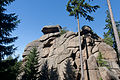
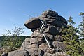
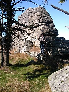
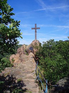
The Ottofels ("Otto Rock"), named after Prince Otto of Stolberg-Wernigerode, is a tor and natural monument near Wernigerode in the Harz mountains of central Germany.

The County of Stolberg-Wernigerode was a county of the Holy Roman Empire located in the Harz region around Wernigerode, now part of Saxony-Anhalt, Germany. It was ruled by a branch of the House of Stolberg.

Tor (rock formation) Large, free-standing rock outcrop that rises abruptly from the surrounding smooth and gentle slopes of a rounded hill summit or ridge crest

A tor, which is also known by geomorphologists as either a castle koppie or kopje, is a large, free-standing rock outcrop that rises abruptly from the surrounding smooth and gentle slopes of a rounded hill summit or ridge crest. In the South West of England, the term is commonly also used for the hills themselves – particularly the high points of Dartmoor in Devon and Bodmin Moor in Cornwall.

Natural monument natural or natural/cultural feature of outstanding or unique value

A natural monument is a natural or natural/cultural feature of outstanding or unique value because of its inherent rarity, representative of aesthetic qualities or cultural significance.

The Ottofels or Ottofelsen [1] lie about 2.5 km southwest of Hasserode in the borough of Wernigerode. It can only be reached on foot, either from the Steinerne Renne halt on the Harz Railway and Brocken Railway or from the car park at the junction of the Thumkuhle and Dränge valleys not far from the road to Drei Annen Hohne.

Hasserode human settlement in Germany

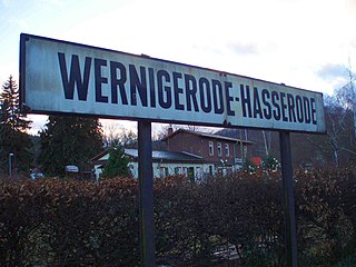
Hasserode has been a quarter in the town of Wernigerode since 1907, a town in the German state of Saxony-Anhalt.

Steinerne Renne

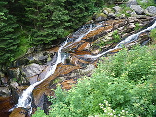
The Steinerne Renne is a waterfall and natural monument near the town of Wernigerode in the Harz mountains of central Germany.

Harz Railway railway line

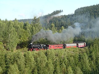
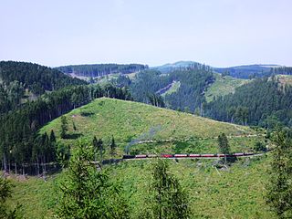
The Harz Railway or Trans-Harz Railway was formerly the main line of the Harz Narrow Gauge Railways and runs north to south right across the Harz Mountains from Wernigerode to Nordhausen. However, the tourist attraction of the Brocken, the highest mountain in the Harz, is so great that the Brocken Railway is effectively the main line today. The Trans-Harz Railway joins up with the Selke Valley Railway to Quedlinburg at Eisfelder Talmühle where all trains are organised to make good connections.

The rocks stand at a height of 584 metres above sea level [2] [3] and are 36 metres high. [2] They are made of coarse-grained granite and have been weathered to form a tor. On 27 July 1892 there was a ceremony to mark the completion of public access to the top, which consisted of several iron ladders. [2] These ladders were replaced after the Wende in 1990. In addition the Ottofels is used for rock climbing by mountaineers.

Normalnull

Normalnull or Normal-Null is an outdated official vertical datum used in Germany. Elevations using this reference system were to be marked "Meter über Normal-Null". Normalnull has been replaced by Normalhöhennull.

Granite A common type of intrusive, felsic, igneous rock with granular structure

Granite is a common type of felsic intrusive igneous rock that is granular and phaneritic in texture. Granites can be predominantly white, pink, or gray in color, depending on their mineralogy. The word "granite" comes from the Latin granum, a grain, in reference to the coarse-grained structure of such a holocrystalline rock. Strictly speaking, granite is an igneous rock with between 20% and 60% quartz by volume, and at least 35% of the total feldspar consisting of alkali feldspar, although commonly the term "granite" is used to refer to a wider range of coarse-grained igneous rocks containing quartz and feldspar.

<i lang="de" title="German language text">Die Wende</i>

Die Wende is a German term that has come to signify the complete process of change from the rule of the Socialist Unity Party of Germany and a centrally planned economy to the revival of parliamentary democracy and a market economy in the German Democratic Republic around 1989 and 1990. It encompasses several processes and events which later have become synonymous with the overall process. These processes and events are:

From the summit there is a panoramic view of the mountains and valleys of the Harz as far as its highest peak, the Brocken, and far over the northern Harz Foreland.

Brocken Harz mountain in Germany

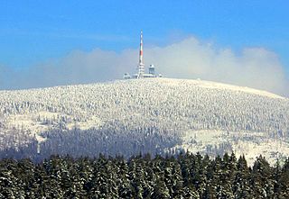
The Brocken, also sometimes referred to as the Blocksberg, is the highest peak of the Harz mountain range and also the highest peak of Northern Germany; it is located near Schierke in the German state of Saxony-Anhalt between the rivers Weser and Elbe. Although its elevation of 1,141 metres (3,743 ft) is below alpine dimensions, its microclimate resembles that of mountains of about 2,000 m (6,600 ft). The peak above the tree line tends to have a snow cover from September to May, and mists and fogs shroud it up to 300 days of the year. The mean annual temperature is only 2.9 °C (37.2 °F). It is the easternmost mountain in northern Germany; travelling east in a straight line, the next prominent elevation would be in the Ural Mountains in Russia.

The Ottofels is checkpoint no. 27 in the Harzer Wandernadel hiking network. [4]

Harzer Wandernadel

The Harzer Wandernadel is a system of hiking awards in the Harz mountains in central Germany. The hiker can earn awards at different levels of challenge by walking to the various checkpoints in the network and stamping his or her passbook to record the visit. With 222 checkpoints in three federal states and across five districts in the Harz and with membership in five figures, the system has gained a following Germany-wide.

Photographs

See also: Rock formations in the Harz

Related Research Articles

Wernigerode Place in Saxony-Anhalt, Germany

Wernigerode is a town in the district of Harz, Saxony-Anhalt, Germany. Until 2007, it was the capital of the district of Wernigerode. Its population was 35,041 in 2012.

Selke Valley Railway railway line

The Selke Valley Railway (Selketalbahn), Gernrode-Harzgerode Railway and the Anhalt Harz Railway were different names for the metre gauge railway in the Lower Harz, Germany, originally owned by the Gernrode-Harzgerode Railway Company.

Harz Narrow Gauge Railways railway company in Germany operating metre-gauge lines in Saxony-Anhalt

The Harz Narrow Gauge Railways is a railway company that operates a 1,000 mm metre-gauge network in the Harz mountains, in central Germany. The company was formed after the Second World War as a merger of two earlier companies. It owns about 140 kilometres of track, connecting the principal towns of Wernigerode, Nordhausen and Quedlinburg and several smaller settlements in the area. Much of the network is steeply graded and picturesque, but its most popular destination is the Brocken, the highest mountain in the region. The company runs a significant number of its trains with steam haulage, mostly employing 1950s vintage 2-10-2 tank locomotives, hauling traditional open-platform bogie carriages. The company is mainly owned by the various local authorities whose territories it serves.

Schierke Stadtteil of Wernigerode in Saxony-Anhalt, Germany

Schierke is a village and a former municipality in the Harz district, in the German state of Saxony-Anhalt. Since 1 July 2009, it is part of the town Wernigerode. Situated within the Harz mountain range in the valley of the Bode River, at the rim of the Harz National Park, it is mainly a tourist resort, especially for hiking and all kinds of winter sport.

Brocken Railway railway line

The Brocken Railway is one of three tourist metre gauge railways which together with the Harz Railway and Selke Valley Railway form the Harz Narrow Gauge Railways railway network in the Harz mountain range of Germany.

Zeterklippen mountain

The Zeterklippen are a striking rock formation or tor on the 930-metre-high Renneckenberg mountain, overlooking the Ilse valley in the Harz mountains in Germany. The Renneckenberg is an eastern sub-peak of the Brocken. The rocks themselves lie at a height of about 830 metres (2,720 ft) above sea level. They can be reached from the Molkenhausstern after about 2.5 km. The track initially runs uphill through dense spruce forest until the view opens out towards the Hohnekamm and down to Wernigerode. Then the route branches off to the right onto a steep, 0.5 km, path and, after about 200 m, a gentler 0.4 km path leads to the Große Zeterklippe. Immediately below this highest of the rocks is a mountain hut that dates to the time when a botanical garden had been laid out here as a replacement for the inaccessible Brockengarten.

Heinrichshöhe mountain

The Heinrichshöhe is a subsidiary peak of the highest mountain in the Harz, the Brocken, and, at 1,040 m above NN, it is the second summit in the Harz Mountains.

Hohnekamm mountain

The Hohnekamm or Hohne Kamm is a mountain ridge up to 900 m above sea level high in the Harz mountains of central Germany. It is located in the state of Saxony-Anhalt, and is well known for its rock towers or tors, the Hohneklippen.

Hirschhorn Crags

The Hirschhorn Rocks are a natural monument in the Harz National Park in central Germany.

Drei Annen Hohne human settlement in Germany

Drei Annen Hohne is the name of a small settlement within the municipal area of Wernigerode in Saxony-Anhalt, Germany.

Kapellenklippe

The Kapellenklippe is a tor near the Glassworks Way (Glashüttenweg) on the Renneckenberg mountain in the High Harz in central Germany within the borough of Wernigerode. The tor is in a remote spot in the Harz National Park and can only be reached over unsigned paths. The summit of the rocks is 927 m above sea level and looks a bit like a bell. The tor is a popular destination for climbers. From its summit there is a view towards the Brocken. The tor is almost completely overgrown with pine trees and only projects a few metres above the tops of the trees.

Trudenstein

The Trudenstein is a rock formation and popular hiker's destination in the Harz Mountains of central Germany. It is located in the federal state of Saxony-Anhalt.

Ilse valley valley in Ilsenburg, Germany

The Ilse valley is the ravine of the Ilse creek in the northern boundary of the Harz mountain range in Germany. Part of the Harz National Park, it runs from the town of Ilsenburg at the foot of the mountain range up to the source region near the summit of the Brocken massif, the highest mountain of the range. The scenic valley is a popular hiking area.

Ilsestein

The Ilsestein is a prominent granite rock formation near the town of Ilsenburg in the Harz mountains of central Germany. Offering a scenic view over the Ilse valley to the Brocken massif, the highest mountain of the range, it is today a popular tourist destination.

The Eckerloch is a forested mountain valley, 845 metres above sea level near the village of Schierke in the Harz Mountains of central Germany.

The Ahrensklint or Ahrentsklint in the Harz Mountains is a granite rock formation, 822.4 m above sea level (NN), on the Erdbeerkopf in Harz district in the German state of Saxony-Anhalt.

Barenberg (Schierke) mountain in the Harz, Germany

The Barenberg, also called the Bärenberg or Bärenkopf, is a mountain, 695.5 m above sea level (NN), in the Harz Mountains of Germany near the village of Schierke, Harz county, in the state of Saxony-Anhalt.

Elversstein

The Elversstein in the Harz Mountains of Germany is a granite rock formation with a maximum elevation of 499 m above sea level (NN) on the Steinberg near Hasserode in the county of Harz in Saxony-Anhalt.

References

  1. Der Ottofelsen, auf harzlife.de
  2. 1 2 3 Der Ottofels, auf ausflugsziele-harz.de
  3. Saxony-Anhalt viewer of the State Office for Survey and Geoinformation (Landesamt für Vermessung und Geoinformation)
  4. Harzer Wandernadel: Stempelstelle 27 / Ottofelsen auf harzer-wandernadel.de


Coordinates: 51°47′49″N10°42′43″E / 51.79694°N 10.71194°E / 51.79694; 10.71194

Geographic coordinate system Coordinate system

A geographic coordinate system is a coordinate system that enables every location on Earth to be specified by a set of numbers, letters or symbols. The coordinates are often chosen such that one of the numbers represents a vertical position and two or three of the numbers represent a horizontal position; alternatively, a geographic position may be expressed in a combined three-dimensional Cartesian vector. A common choice of coordinates is latitude, longitude and elevation. To specify a location on a plane requires a map projection.