
Elbingerode is an Ortsteil of Oberharz am Brocken in the Harz district, in the German state of Saxony-Anhalt. The former town was incorporated into the newly established municipality on 1 January 2010.

Benneckenstein is a town in the district of Harz, in Saxony-Anhalt, Germany. Since 1 January 2010, it has been part of the town of Oberharz am Brocken. Benneckenstein is in the eastern Harz, 14 km southeast of Braunlage, and 24 km south of Wernigerode.
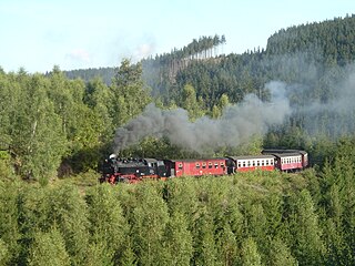
The Harz Railway or Trans-Harz Railway was formerly the main line of the Harz Narrow Gauge Railways and runs north to south right across the Harz Mountains from Wernigerode to Nordhausen. However, the tourist attraction of the Brocken, the highest mountain in the Harz, is so great that the Brocken Railway is effectively the main line today. The Trans-Harz Railway joins up with the Selke Valley Railway to Quedlinburg at Eisfelder Talmühle where all trains are organised to make good connections.
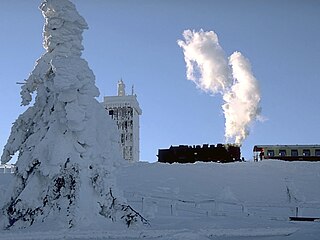
The Brocken Railway is one of three tourist metre gauge railways which together with the Harz Railway and Selke Valley Railway form the Harz Narrow Gauge Railways railway network in the Harz mountain range of Germany.
Elend is a district of the town of Oberharz am Brocken in the Harz District, in Saxony-Anhalt, Germany. It lies in the Bode valley in the High Harz in central Germany, at a height of 505 m above NN. This part of the valley is known locally as Elendstal. Elend is located near the former Inner German Border between West and East Germany.

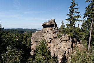
The Wolfsklippen, also called the Wolfsklippe, is a granite mountain in the Harz mountains in Central Germany with an observation platform on the summit. Its height is frequently given as about 723 m above sea level (NN), but occasionally also as only around 710 m above NN.

The Hohnekamm or Hohne Kamm is a mountain ridge up to 900 m above sea level high in the Harz mountains of central Germany. It is located in the state of Saxony-Anhalt, and is well known for its rock towers or tors, the Hohneklippen.

The Harz Witches' Trail is a footpath, just under 100 km long, in Germany that runs from Osterode through the Harz mountains and over its highest peak, the Brocken, to Thale. It is a project by the Harz Transport Association and Harz Club and is part of the system of trails known as the Harzer Wandernadel.
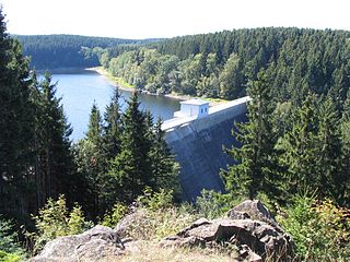
The Zillierbach Dam lies in the East Harz in the German state of Saxony-Anhalt near the town of Elbingerode (Harz) and impounds the Zillierbach stream. It supplies drinking water to several villages in the High Harz as well as the town of Wernigerode; it also provides flood protection.
The Ottofels, named after Prince Otto of Stolberg-Wernigerode, is a tor and natural monument near Wernigerode in the Harz mountains of central Germany.

Plessenburg is a village in the town of Ilsenburg in the Harz National Park, in the district of Harz in the German state of Saxony-Anhalt.

The Renneckenberg is a mountain, roughly 933 metres (3,061 ft) high, in the High Harz part of the Harz mountain range of central Germany within the borough of Wernigerode in the state of Saxony-Anhalt.

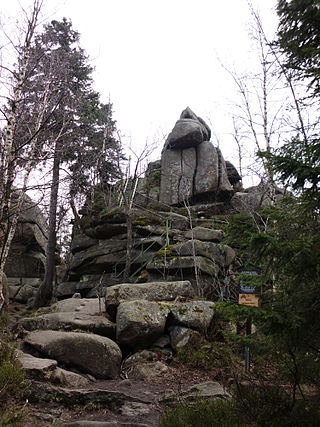
The Trudenstein is a rock formation and popular hiker's destination in the Harz Mountains of central Germany. It is located in the federal state of Saxony-Anhalt.
The Molkenhaus is a historic house near Wernigerode, Harz, Germany, located on the Jägerkopf hill above the Steinerne Renne waterfall and the source region of the Holtemme river. The timber-framed building, which was built by order of the Senior Master Hunter (Oberjägermeister) of the counts of Stolberg, von Meseberg, at the beginning of the 18th century, belonged to the Ilsenburger Marienhof and was used for hunting purposes and the production of butter. Nowadays it is used by the Harz National Park.
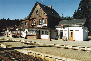
Drei Annen Hohne station is a branch-off station on the Harz Railway and the Brocken Railway.

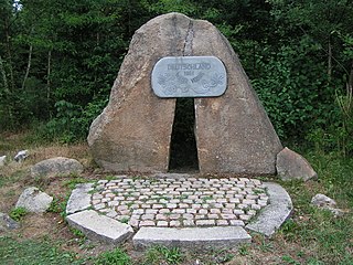
The Dreieckige Pfahl is a historic boundary stone, about 1.35 metres high and made of granite, located southwest of the Brocken, the highest mountain in the Harz Mountains of central Germany. The stone, erected before 1866, marked the border between the Kingdom of Hanover and the Duchy of Brunswick. Originally this spot was a tripoint. During the division of Germany the border between the German Democratic Republic and the Federal Republic of Germany ran past the Dreieckiger Pfahl. Today it marks the border between the states of Saxony-Anhalt and Lower Saxony, the post lying just within the Lower Saxon side. During the Cold War it was accessible from the west.

The Ilse valley is the ravine of the Ilse stream in the northern boundary of the Harz mountain range in Germany. Part of the Harz National Park, it runs from the town of Ilsenburg at the foot of the mountain range up to the source region near the summit of the Brocken massif, the highest mountain of the range. The scenic valley is a popular hiking area.
The Eckerloch is a forested mountain valley, 845 metres above sea level near the village of Schierke in the Harz Mountains of central Germany.
The Ahrensklint or Ahrentsklint in the Harz Mountains is a granite rock formation, 822.4 m above sea level (NN), on the Erdbeerkopf in Harz district in the German state of Saxony-Anhalt.
The Elversstein in the Harz Mountains of Germany is a granite rock formation with a maximum elevation of 499 m above sea level (NN) on the Steinberg near Hasserode in the county of Harz in Saxony-Anhalt.
