Schierke

Last updated
Schierke
Harzwanderung Oberharz um Braunlage - Wurmberg - Weg nach Braunlage -Wurmberg- Blick nach Schierke vom Wurmberg - panoramio.jpg
View from Wurmberg
DE-ST 15-0-85-370 Schierke COA.png
Location of Schierke
Schierke
Germany adm location map.svg
Red pog.svg
Schierke
Saxony-Anhalt location map.svg
Red pog.svg
Schierke
Coordinates: 51°45′50″N10°39′53″E / 51.76389°N 10.66472°E / 51.76389; 10.66472 Coordinates: 51°45′50″N10°39′53″E / 51.76389°N 10.66472°E / 51.76389; 10.66472
Country Germany
State Saxony-Anhalt
District Harz
Town Wernigerode
Area
  Total40.13 km2 (15.49 sq mi)
Elevation
610 m (2,000 ft)
Population
 (2006-12-31)
  Total721
  Density18/km2 (47/sq mi)
Time zone UTC+01:00 (CET)
  Summer (DST) UTC+02:00 (CEST)
Postal codes
38879
Dialling codes 039455
Vehicle registration HZ
Website www.schierke-am-brocken.de

Schierke is a village and a former municipality in the Harz district, in the German state of Saxony-Anhalt. Since 1 July 2009, it is part of the town Wernigerode. Situated within the Harz mountain range in the valley of the river Bode, at the rim of the Harz National Park, it is mainly a tourist resort, especially for hiking and all kinds of winter sports.

Contents

Geography

1912 map of Schierke Schierke Karte 1912.JPG
1912 map of Schierke

Location

The winter sport and climatic spa of Schierke lies in the High Harz mountains, southeast of their highest summit, the Brocken. It is situated in the Harz/Saxony-Anhalt Nature Park and borders on the Harz National Park in the north. Situated 600 to 650 m above sea level in the valley of the Cold Bode, the parish of Schierke has an area of 40.1 km² and a population of 713 (as at 31 December 2007).

Today Schierke again is a popular place to start or finish a walk to the Brocken massif via the Goetheweg or the Glashüttenweg. It has bus service and access to the Brocken Railway, whose station is located about 100 metres above the village. A popular attraction in the area is the "Brocken Coaster", a local summer rodelbahn. Schierke is also not far from downhill skiing destinations such as the slope of the Wurmberg mountain, the second highest of the Harz. Another winter activity in the area involves hiring or obtaining a sled and riding it down the "bob bahn" – a local tobogganing track.

Climatic diagram of Schierke Klimadiagramm-deutsch-Schierke (ST)-Deutschland.png
Climatic diagram of Schierke

Climate

The average air temperature in Schierke is 5.3 °C, and it has an annual precipitation of 1,275 millimetres.

History

Schierke around 1900 as a photochrom from the Library of Congress collection Schierke 1900.jpg
Schierke around 1900 as a photochrom from the Library of Congress collection

The field name of Schierke was first mentioned in the records in 1590 as Schiriken (the German word schier means, in the Harz area, an utterly, unspoilt wood (blankes, reines Holz). Hitherto there had been a sawmill in 1506, below the site of the subsequent village, in Elend, and a smelting works above the Cold Bode near the moor slags (Moorschlacken). A first church at the site was consecrated in 1691.

On 20 June 1898 Schierke was connected to Wernigerode by the Brocken Railway line, today run by the Harz Narrow Gauge Railways, and on 4 October 1898 the line was extended up to the Brocken summit. Thereupon, Schierke became a popular tourist destination and numerous hotels and villas arose. In 1914 and again in 1934 it was the site of the German Skeleton Championships. Schierke became a municipality in its own right in 1924.

After World War II, however, due to its location next to the inner German border, Schierke for a long time was not accessible to the public for winter sports. Visits required an extra permission by East German authorities between 1952 and 1989. Several hotels were converted into public holiday resorts of the Free German Trade Union Federation (FDGB) and of the Stasi ministry. Barracks for the Border Troops of the German Democratic Republic stood on the site of the present training centre for engineering and metallurgy. The 7th Border Company of the 20th Border Regiment guarded the stretch of border from the Brocken plateau via former Goetheweg station and the Dreieckiger Pfahl border stone (checkpoint no. 168 in the Harzer Wandernadel) to the Großer Winterberg. Each troop was stationed for a week at a time in the present-day station building on the peak of the Brocken.

After German reunification, tourism again prospered and many villas were restored. On 13 January 2009 Mayor Hans-Jochen Ermisch, and his counterpart from Wernigerode, Peter Gaffert, signed the treaty incorporating Schierke into Wernigerode. [2] This merger came into effect on 1 July 2009. [3] Since then, the Wernigerode town council has made comprehensive efforts to develop Schierke as a resort town.

Politics

Coat of arms DE-ST 15-0-85-370 Schierke COA.png
Coat of arms

Coat of arms

The coat of arms was granted to Schierke on 5 May 1939 by the governor (Oberpräsident) of the Province of Saxony.

Emblazonment: "On a field or, a stag's skull and antlers sable" ("In gold ein schwarzer Hirsch-Schädel mit Geweih im Visier").

The stag's antlers epitomize the "King of the Harz Forest", the dominant wild animal in the mountain forests around Schierke. Just as the antlers are the crown of the deer, Schierke, on the Brocken, "crowns" the Harz landscape with its natural beauty and its healing climate.

The coat of arms was designed by the head of the Magdeburg state archives, Otto Korn.

Memorials

Places of interest

Sport and hiking

The area around Schierke is criss-crossed by numerous trails, several leading up to the top of the Brocken. There is a choice of longer or shorter, but usually steeper, walks. The Wurmberg Trail (Wurmbergstieg) runs up to the summit of the Wurmberg. From the station, a trail runs directly to the tor known as the Feuersteinklippe. For winter sports lovers, Schierke has an extensive cross-country skiing trail network and a natural ice rink.

In the first half of the 20th century Schierke was known for its skeleton run, where the German Championships were twice held – in 1914 and 1934. In 1950 the first East German national winter sports championships took place here, being portrayed on one of two special stamps by the East German Deutsche Post.

In Schierke there is a summer rodelbahn, the Brockencoaster with a sun terrace.

Notable people

Johann Wolfgang von Goethe visited Schierke in 1784. The Walpurgis Night scene in Faust: The First Part of the Tragedy is set in the "District of Schierke and Elend".

Schierker Feuerstein

Feuersteinklippe rock Feuersteinklippen.JPG
Feuersteinklippe rock

Schierker Feuerstein is a herbal liqueur and digestif (35% abv), patented in 1924 by the local chemist, Willy Drube. The red-brown beverage is named after the red granite of the Feuersteinklippe, a tor-like rock formation nearby. After World War II the production at first continued in Bad Lauterberg on the western side of the inner German border, but was also resumed in Schierke from 1972 on as Volkseigener Betrieb . After reunification the enterprises merged while the Feuerstein is still bottled at both locations.

Related Research Articles

<span class="mw-page-title-main">Wernigerode</span> Town in Saxony-Anhalt, Germany

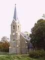
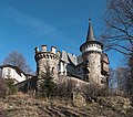
Wernigerode is a town in the district of Harz, Saxony-Anhalt, Germany. Until 2007, it was the capital of the district of Wernigerode. Its population was 35,041 in 2012.

<span class="mw-page-title-main">Harz</span> Low mountain range in northern Germany

The Harz is a highland area in northern Germany. It has the highest elevations for that region, and its rugged terrain extends across parts of Lower Saxony, Saxony-Anhalt, and Thuringia. The name Harz derives from the Middle High German word Hardt or Hart, Latinized as Hercynia. The Brocken is the highest summit in the Harz with an elevation of 1,141.1 metres (3,744 ft) above sea level. The Wurmberg is the highest peak located entirely within the state of Lower Saxony.

<span class="mw-page-title-main">Brocken</span> Highest peak of the Harz

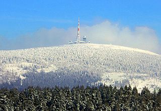
The Brocken, also sometimes referred to as the Blocksberg, is the highest peak in the Harz mountain range and also the highest peak in Northern Germany; it is near Schierke in the German state of Saxony-Anhalt between the rivers Weser and Elbe. Although its elevation of 1,141 metres (3,743 ft) is below alpine dimensions, its microclimate resembles that of mountains of about 2,000 m (6,600 ft). The peak above the tree line tends to have a snow cover from September to May, and mists and fogs shroud it up to 300 days of the year. The mean annual temperature is only 2.9 °C (37.2 °F). It is the easternmost mountain in northern Germany; travelling east in a straight line, the next prominent elevation would be in the Ural Mountains in Russia.

<span class="mw-page-title-main">Braunlage</span> Place in Lower Saxony, Germany

Braunlage is a town and health resort in the Goslar district of Lower Saxony in Germany. Situated within the Harz mountain range, south of the Brocken massif, Braunlage's main business is tourism, particularly skiing. Nearby ski resorts include the Sonnenberg and the slopes on the Wurmberg.

<span class="mw-page-title-main">Wurmberg Gondola Lift</span>

The Wurmberg Gondola Lift is a monocable gondola lift with a length of 1.7 miles (2.7 km), built in 1963, leading from the Braunlage tourist resort within the Harz mountain range on the top of the 3,185 feet (971 m) high Wurmberg mountain.

<span class="mw-page-title-main">Harz Railway</span>

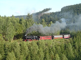
The Harz Railway or Trans-Harz Railway was formerly the main line of the Harz Narrow Gauge Railways and runs north to south right across the Harz Mountains from Wernigerode to Nordhausen. However, the tourist attraction of the Brocken, the highest mountain in the Harz, is so great that the Brocken Railway is effectively the main line today. The Trans-Harz Railway joins up with the Selke Valley Railway to Quedlinburg at Eisfelder Talmühle where all trains are organised to make good connections.

<span class="mw-page-title-main">Brocken Railway</span> Tourist metre gauge railway in the Harz mountain range of Germany

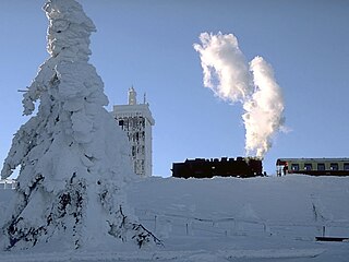
The Brocken Railway is one of three tourist metre gauge railways which together with the Harz Railway and Selke Valley Railway form the Harz Narrow Gauge Railways railway network in the Harz mountain range of Germany.

<span class="mw-page-title-main">Wurmberg (Harz)</span> German mountain

At 971 m above sea level (NN) the Wurmberg is the second highest mountain in the Harz and the highest in Lower Saxony (Germany).

<span class="mw-page-title-main">Hohnekamm</span>

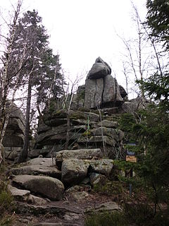
The Hohnekamm or Hohne Kamm is a mountain ridge up to 900 m above sea level high in the Harz mountains of central Germany. It is located in the state of Saxony-Anhalt, and is well known for its rock towers or tors, the Hohneklippen.

<span class="mw-page-title-main">Kalte Bode</span> River in Germany

The Kalte Bode is the left-hand headstream of the Bode in the High Harz Mountains in the German state of Saxony-Anhalt. It is 17 kilometres (11 mi) long.

<span class="mw-page-title-main">Renneckenberg</span>

The Renneckenberg is a mountain, roughly 933 metres (3,061 ft) high, in the High Harz part of the Harz mountain range of central Germany within the borough of Wernigerode in the state of Saxony-Anhalt.

<span class="mw-page-title-main">Trudenstein</span> Rock formation in Germany

The Trudenstein is a rock formation and popular hiker's destination in the Harz Mountains of central Germany. It is located in the federal state of Saxony-Anhalt.

<span class="mw-page-title-main">Schierke station</span>

Schierke station is the railway station in the village of Schierke operated by the Harz Narrow Gauge Railways on the Brocken Railway in the Harz Mountains of central Germany. Schierke itself lies as the foot of the highest mountain in the Harz, the Brocken, and is located in the borough of Wernigerode in the federal state of Saxony-Anhalt.

The Eckerloch is a forested mountain valley, 845 metres above sea level near the village of Schierke in the Harz Mountains of central Germany.

<span class="mw-page-title-main">Ahrentsklint</span>

The Ahrensklint or Ahrentsklint in the Harz Mountains is a granite rock formation, 822.4 m above sea level (NN), on the Erdbeerkopf in Harz district in the German state of Saxony-Anhalt.

<span class="mw-page-title-main">Scherstorklippen</span>

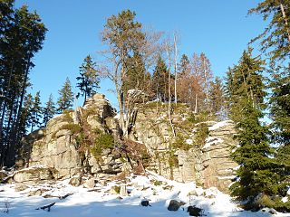
The Scherstorklippen is a granite tor in the Harz Mountains of central Germany. It is located near the village of Schierke in the county of Harz in the state of Saxony-Anhalt. It was formed by the process of spheroidal weathering.

<span class="mw-page-title-main">Barenberg (Schierke)</span>

The Barenberg, also called the Bärenberg or Bärenkopf, is a mountain, 695.5 m above sea level (NN), in the Harz Mountains of Germany near the village of Schierke, Harz county, in the state of Saxony-Anhalt.

<span class="mw-page-title-main">Großer Winterberg (Harz)</span>

The Großer Winterberg is a mountain, 906.4 m above sea level (NN), and a subpeak of the Wurmberg, the highest mountain in the neighbouring state of Lower Saxony in the High Harz of central Germany. The Großer Winterberg rises within the borough of Wernigerode in the county of Harz in the state of Saxony-Anhalt.

The Kleiner Winterberg is a mountain, 837 m above sea level (NN), in the borough of Wernigerode, Harz county, in the German state of Saxony-Anhalt. It is found in the Harz Mountains and is a subpeak of the Wurmberg, the highest point in the neighbouring state of Lower Saxony.

References