Harz National Park is a nature reserve in the German federal states of Lower Saxony and Saxony-Anhalt. It comprises portions of the western Harz mountain range, extending from Herzberg and Bad Lauterberg at the southern edge to Bad Harzburg and Ilsenburg on the northern slopes. 95 % of the area is covered with forests, mainly with spruce and beech woods, including several bogs, granite rocks and creeks. The park is part of the Natura 2000 network of the European Union.
Germany, officially the Federal Republic of Germany, is a country in Central and Western Europe, lying between the Baltic and North Seas to the north, and the Alps to the south. It borders Denmark to the north, Poland and the Czech Republic to the east, Austria and Switzerland to the south, France to the southwest, and Luxembourg, Belgium and the Netherlands to the west.
A landmark is a recognizable natural or artificial feature used for navigation, a feature that stands out from its near environment and is often visible from long distances.
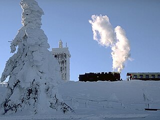
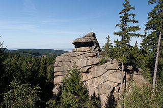
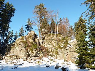
The Feuersteinklippe is a butte made of granite, not flint (Feuerstein = "firestone" or flint) as the name suggests. It shows the spheroidal weathering typical of the Harz region. The striking rock formation is located at a height of 690 metres and is surrounded by woods. It lies to the north of Schierke station.
In geomorphology, a butte is an isolated hill with steep, often vertical sides and a small, relatively flat top; buttes are smaller landforms than mesas, plateaus, and tablelands. The word "butte" comes from a French word meaning "small hill"; its use is prevalent in the Western United States, including the southwest where "mesa" is used for the larger landform. Because of their distinctive shapes, buttes are frequently landmarks in plains and mountainous areas. In differentiating mesas and buttes, geographers use the rule of thumb that a mesa has a top that is wider than its height, while a butte has a top that is narrower than its height.
Granite is a common type of felsic intrusive igneous rock that is granular and phaneritic in texture. Granites can be predominantly white, pink, or gray in color, depending on their mineralogy. The word "granite" comes from the Latin granum, a grain, in reference to the coarse-grained structure of such a holocrystalline rock. Strictly speaking, granite is an igneous rock with between 20% and 60% quartz by volume, and at least 35% of the total feldspar consisting of alkali feldspar, although commonly the term "granite" is used to refer to a wider range of coarse-grained igneous rocks containing quartz and feldspar.
Flint is a hard, sedimentary cryptocrystalline form of the mineral quartz, categorized as a variety of chert. It occurs chiefly as nodules and masses in sedimentary rocks, such as chalks and limestones. Inside the nodule, flint is usually dark grey, black, green, white or brown in colour, and often has a glassy or waxy appearance. A thin layer on the outside of the nodules is usually different in colour, typically white and rough in texture. From a petrological point of view, "flint" refers specifically to the form of chert which occurs in chalk or marly limestone. Similarly, "common chert" occurs in limestone.
The name Feuersteinklippe is derived from the Schierker Feuersteinwiesen (Schierke Feuerstein meadows) that lie to the southeast, which in turn were named after the cultic fires or signal beacons originally lit at this spot.
An information board on the rocks recalls the visit of Goethe and the painter, Georg Melchior Kraus, who spent time here on 4 September 1784 in geological studies.
Georg Melchior Kraus was a German painter. A student of Johann Heinrich Tischbein, he was also a teacher himself, as well as an entrepreneur and friend of Goethe. He was a co-founder of the Fürstliche freie Zeichenschule Weimar with Friedrich Justin Bertuch in 1776.
The well-known herbal liqueur, Schierker Feuerstein, which is made in Schierke, is named after the rocks. The label portrays the rock formation.
Schierker Feuerstein is a German herbal liqueur, a half-bitters at a strength of 35% alcohol by volume, originally produced in the village of Schierke, located in the Upper Harz region of Saxony-Anhalt, Germany. Due to its red-brown coloration, the liqueur is named after the so-called Feuersteinklippe, a rock formation near the village made of reddish granite.
Gorsemann, Sabine and Kaiser, Christian (2010). Harz, DuMont Reiseverlag Ostfildern, ISBN978-3-7701-7298-6, p.151
The International Standard Book Number (ISBN) is a numeric commercial book identifier which is intended to be unique. Publishers purchase ISBNs from an affiliate of the International ISBN Agency.
This page is based on this Wikipedia article Text is available under the CC BY-SA 4.0 license; additional terms may apply. Images, videos and audio are available under their respective licenses.
Related Research Articles
The Wurmberg Gondola Lift is a monocable gondola lift with a length of 1.7 miles (2.7 km), built in 1963, leading from the Braunlage tourist resort within the Harz mountain range on the top of the 3,185 feet (971 m) high Wurmberg mountain.
The Brocken Railway is one of three tourist metre gauge railways which together with the Harz Railway and Selke Valley Railway form the Harz Narrow Gauge Railways railway network in the Harz mountain range of Germany.
The Zeterklippen are a striking rock formation or tor on the 930 metre high Renneckenberg mountain, overlooking the Ilse valley in the Harz mountains in Germany. The Renneckenberg is an eastern sub-peak of the Brocken. The rocks themselves lie at a height of about 830 metres (2,720 ft) above sea level. They can be reached from the Molkenhausstern after about 2.5 km. The track initially runs uphill through dense spruce forest until the view opens out towards the Hohnekamm and down to Wernigerode. Then the route branches off to the right onto a steep, 0.5 km, path and, after about 200 m, a gentler 0.4 km path leads to the Große Zeterklippe. Immediately below this highest of the rocks is a mountain hut that dates to the time when a botanical garden had been laid out here as a replacement for the inaccessible Brockengarten.
The Kahle Klippe is a rock formation in the High Harz in central Germany on the eastern slope of the Brocken above the valley of the Ecker.
The Ottofels, named after Prince Otto of Stolberg-Wernigerode, is a tor and natural monument near Wernigerode in the Harz mountains of central Germany.
Drei Annen Hohne is the name of a small settlement within the municipal area of Wernigerode in Saxony-Anhalt, Germany.
The Feigenbaumklippe is a rock formation in the Oker valley in the Harz mountains of central Germany. They lie on the hiking trail from the Kästeklippen crags to Romkerhall Waterfall. These granite rocks, which show clear signs of "wool sack weathering" (Wollsackverwitterung) are a favourite destination for hikers and offer a good view of the valley towards the west. The observation point has safety railings.
The Teufelsmauer is a rock formation made of hard sandstones of the Upper Cretaceous in the northern part of the Harz Foreland in central Germany. This wall of rock runs from Blankenburg (Harz) via Weddersleben and Rieder to Ballenstedt. The most prominent individual rocks of the Teufelsmauer have their own names. The Teufelsmauer near Weddersleben is also called the Adlersklippen.
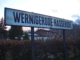
Hasserode has been a quarter in the town of Wernigerode since 1907, a town in the German state of Saxony-Anhalt.
The Trudenstein is a rock formation and popular hiker's destination in the Harz Mountains of central Germany. It is located in the federal state of Saxony-Anhalt.
Schnarcherklippen is the name of a rock formation south of the village of Schierke in the High Harz mountains of Saxony-Anhalt in central Germany. The name translates roughly to "snoring crags" or "snoring rocks".
Schierke station is the railway station in the village of Schierke operated by the Harz Narrow Gauge Railways on the Brocken Railway in the Harz Mountains of central Germany. Schierke itself lies as the foot of the highest mountain in the Harz, the Brocken, and is located in the borough of Wernigerode in the federal state of Saxony-Anhalt.
The Ilse valley is the ravine of the Ilse creek in the northern boundary of the Harz mountain range in Germany. Part of the Harz National Park, it runs from the town of Ilsenburg at the foot of the mountain range up to the source region near the summit of the Brocken massif, the highest mountain of the range. The scenic valley is a popular hiking area.
The Eckerloch is a forested mountain valley, 845 metres above sea level near the village of Schierke in the Harz Mountains of central Germany.
The Ahrensklint or Ahrentsklint in the Harz Mountains is a granite rock formation, 822.4 m above sea level (NN), on the Erdbeerkopf in Harz district in the German state of Saxony-Anhalt.
The Scherstorklippen is a granite tor in the Harz Mountains of central Germany. It is located near the village of Schierke in the county of Harz in the state of Saxony-Anhalt. It was formed by the process of spheroidal weathering.
The Barenberg, also called the Bärenberg or Bärenkopf, is a mountain, 695.5 m above sea level (NN), in the Harz Mountains of Germany near the village of Schierke, Harz county, in the state of Saxony-Anhalt.
The Helenenruh is a 629 metre high rocky ridge near the village of Elend in the Harz Mountains of central Germany.


 Forest clearing at the rocks
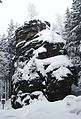 The rocks in winter