The Dreieckige Pfahl ("Triangular Post") is an historic boundary stone, about 1.35 metres high and made of granite, located southwest of the Brocken, the highest mountain in the Harz Mountains of central Germany. The stone, erected before 1866, marked the border between the Kingdom of Hanover and the Duchy of Brunswick. Originally this spot was a tripoint. During the division of Germany the border between the German Democratic Republic and the Federal Republic of Germany ran past the Dreieckiger Pfahl. Today it marks the border between the states of Saxony-Anhalt and Lower Saxony, the post lying just within the Lower Saxon side. During the Cold War it was accessible from the west.

Granite is a common type of felsic intrusive igneous rock that is granular and phaneritic in texture. Granites can be predominantly white, pink, or gray in color, depending on their mineralogy. The word "granite" comes from the Latin granum, a grain, in reference to the coarse-grained structure of such a holocrystalline rock. Strictly speaking, granite is an igneous rock with between 20% and 60% quartz by volume, and at least 35% of the total feldspar consisting of alkali feldspar, although commonly the term "granite" is used to refer to a wider range of coarse-grained igneous rocks containing quartz and feldspar.
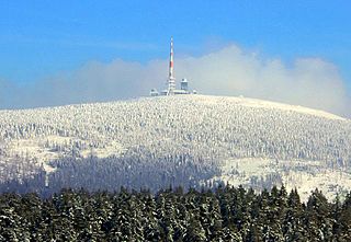
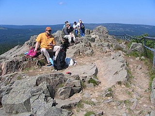
The Brocken, also sometimes referred to as the Blocksberg, is the highest peak of the Harz mountain range and also the highest peak of Northern Germany; it is located near Schierke in the German state of Saxony-Anhalt between the rivers Weser and Elbe. Although its elevation of 1,141 metres (3,743 ft) is below alpine dimensions, its microclimate resembles that of mountains of about 2,000 m (6,600 ft). The peak above the tree line tends to have a snow cover from September to May, and mists and fogs shroud it up to 300 days of the year. The mean annual temperature is only 2.9 °C (37.2 °F). It is the easternmost mountain in northern Germany; travelling east in a straight line, the next prominent elevation would be in the Ural Mountains in Russia.

Germany, officially the Federal Republic of Germany, is a country in Central and Western Europe, lying between the Baltic and North Seas to the north, and the Alps to the south. It borders Denmark to the north, Poland and the Czech Republic to the east, Austria and Switzerland to the south, France to the southwest, and Luxembourg, Belgium and the Netherlands to the west.
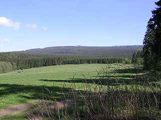
The historic stone stands at an elevation of about 870 metres, around 2.5 kilometres east of a car park on the B 4 federal road between Torfhaus and Oderbrück.

The Bundesstraße 4 is a German federal highway running in a northwesterly to southly direction from the state of Schleswig-Holstein to Bavaria. It provides a direct route for motorists traveling between Hamburg and Nuremberg.

Torfhaus is a village in the borough of the mining town of Altenau in the Harz mountains of Germany and lies at a height of about 800 m above sea level (NN). It is the highest settlement in Lower Saxony.
The first recorded mention of a boundary stone being located here dates to the year 1727. On a map of the Upper Forest of Braunlage (Oberforst Braunlage) is the note "drey Eckjer Pfahl anno 1698". From a description of the Harzburg Forest (Harzburger Forsten) the original stone is described thus:
Solcher Pfahl ist auch nach Communion Seite zur linken Hand mit Nr. 1 und einer Wolfsangel, nach Braunlagischer Seite mit drey Hieben und auf Elbingeroder Seite mit Nr. 1 und einem Kreuz ingleichen mit der Jahreszahl 1698 gesetzt und hat dabei seinen Namen erhalten.
...which translates roughly as...
Such a post was also erected with a No. 1 and a wolfsangel inscribed on the left hand side facing Communion, three gashes on the Elbingerode side, and a No. 1 and a cross with the year 1698 inscribed on the Braunlage side; hence its name.
The Wolfsangel is a German heraldic charge inspired by historic wolf traps, consisting of two metal parts and a connecting chain. The top part of the trap, which resembled a crescent moon with a ring inside, used to be fastened between branches of a tree in the forest while the bottom part, on which meat scraps used to be hung, was a hook meant to be swallowed by a wolf. The simplified design based on the iron "wolf-hook" was often heavily stylized to no longer resemble a baited hook hung from a tree or an entire wolf traps. Other names included Wolfsanker ("wolf-anchor") or Wolfsjagd as well as hameçon or hameçon de loup, a half-moon shape with a ring, or as cramp or crampon in English with a ring at the center, sometimes also called Doppelhaken ("double-hook"), or a crampon with a transversal stroke. All of these symbols are still found in a number of municipal coats of arms in Germany. The crampon is also found as a mason's mark in medieval stonework.

The boundary markers were subsequently replaced on a regular basis. In 1736 a wooden post was erected and, in 1791, one made of stone. In 1844 a new post was made in oakwood.
The present triangular stone was erected before 1866. It bears the No. 1 and, on its northeastern and southwestern sides the letters KH for Kingdom of Hanover, and on the southeastern side the letters HB for the Duchy of Brunswick (Herzogtum Braunschweig). The original triangular shape was retained.
In 1894 a railway station was planned at the site of the Dreieckiger Pfahl. Engineer Louis Degen, who had drawn up plans for a Harz railway running on the territory of Brunswick from Walkenried via Wieda to Braunlage (later called the South Harz Railway), envisaged an extension of the line to the most northerly point of this piece of Brunswick terrain – the district of Blankenburg.
Walkenried is a municipality in the district of Göttingen, in Lower Saxony, Germany. It is situated in the southern Harz, approx. 15 km south of Braunlage, and 15 km northwest of Nordhausen.
Wieda is a village and a former municipality in the district of Göttingen, in Lower Saxony, Germany. Since 1 November 2016, it is part of the municipality Walkenried.

Braunlage is a town and health resort in the Goslar district in Lower Saxony in Germany. Situated within the Harz mountain range, south of the Brocken massif, Braunlage's main business is tourism, particularly skiing. Nearby ski resorts include the Sonnenberg and the slopes on the Wurmberg.
Previously, in 1892, the construction of a road requested by several parishes in the West Harz, which would have branched off at the Dreieckiger Pfahl from the road from Torfhaus/Oderbrück to Schierke and run to the Brocken Road, had been refused by the Chamber of the Principality of Stolberg-Wernigerode.

Schierke is a village and a former municipality in the Harz district, in the German state of Saxony-Anhalt. Since 1 July 2009, it is part of the town Wernigerode. Situated within the Harz mountain range in the valley of the Bode River, at the rim of the Harz National Park, it is mainly a tourist resort, especially for hiking and all kinds of winter sport.
The station was to have been equipped with a run-around loop. However the railway was only built as far as Braunlage. A goods track ran to the north of Braunlage to the granite quarry on the Wurmberg mountain. But it never reached the Dreieckiger Pfahl.

At 971 m above sea level (NN) the Wurmberg is the second highest mountain in the Harz and the highest in Lower Saxony (Germany).
Until 1945 there was a small restaurant at the Dreieckiger Pfahl, which was mainly frequented by hikers to the Brocken. The building was burnt down by American troops in April 1945, because SS and Wehrmacht soldiers as well as Hitler Youth had been hiding in huts in this area. The pub was never rebuilt.
Today, there is a rest area for hikers and mountain bikers in the vicinity of the Dreieckiger Pfahl as well as box no. 168 on the Harzer Wandernadel network of hiking checkpoints. [1]