

Benzingerode has been a village incorporated into the borough of Wernigerode since 1 April 1993. [1] in the district of Harz in the German state of Saxony-Anhalt.
Benzingerode has been a village incorporated into the borough of Wernigerode since 1 April 1993. [1] in the district of Harz in the German state of Saxony-Anhalt.
Benzingerode lies in the North Harz about 7 kilometres east of Wernigerode, on the old B 6 federal road that runs through the middle of the village and branches off to Silstedt at the eastern exit. Southwest of Benzingerode liest the Stapenberg. A low ridge, the Ziegenberge runs eastwards towards Heimburg on which is the site of an old hillfort, the Struvenburg.

Wernigerode is a town in the district of Harz, Saxony-Anhalt, Germany. Until 2007, it was the capital of the district of Wernigerode. Its population was 35,041 in 2012.

The Selke Valley Railway (Selketalbahn), Gernrode-Harzgerode Railway and the Anhalt Harz Railway were different names for the metre gauge railway in the Lower Harz, Germany, originally owned by the Gernrode-Harzgerode Railway Company.
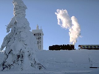
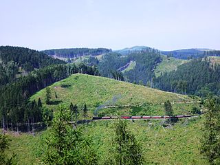
The Brocken Railway is one of three tourist metre gauge railways which together with the Harz Railway and Selke Valley Railway form the Harz Narrow Gauge Railways railway network in the Harz mountain range of Germany.
Harz is a district in Saxony-Anhalt, Germany.

Wernigerode Castle is a schloss located in the Harz mountains above the town of Wernigerode in Saxony-Anhalt, Germany. The present-day building, finished in the late 19th century, is similar in style to Schloss Neuschwanstein, though its foundations are much older. It is open to the public and one of the most frequently visited in Saxony-Anhalt.

The Zeterklippen are a striking rock formation or tor on the 930-metre-high Renneckenberg mountain, overlooking the Ilse valley in the Harz mountains in Germany. The Renneckenberg is an eastern sub-peak of the Brocken. The rocks themselves lie at a height of about 830 metres (2,720 ft) above sea level. They can be reached from the Molkenhausstern after about 2.5 km. The track initially runs uphill through dense spruce forest until the view opens out towards the Hohnekamm and down to Wernigerode. Then the route branches off to the right onto a steep, 0.5 km, path and, after about 200 m, a gentler 0.4 km path leads to the Große Zeterklippe. Immediately below this highest of the rocks is a mountain hut that dates to the time when a botanical garden had been laid out here as a replacement for the inaccessible Brockengarten.
The Stapenberg is a 443-metre-high (1,453 ft) hill spur in the Harz Mountains of central Germany in Harz district in the federal state of Saxony-Anhalt.

Plessenburg is a village in the town of Ilsenburg in the Harz National Park, in the district of Harz in the German state of Saxony-Anhalt.
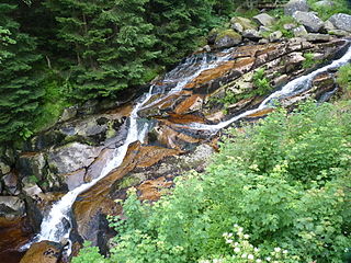
The Steinerne Renne is a waterfall and natural monument near the town of Wernigerode in the Harz mountains of central Germany.

Hasserode Castle in the quarter of the same name in the town of Wernigerode am Harz was a medieval fortification whose site is near Hasserode station on the Harz Narrow Gauge Railways. Today there are no visible traces left of the castle.
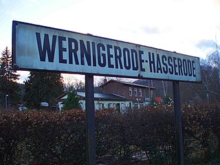
Hasserode has been a quarter in the town of Wernigerode since 1907, a town in the German state of Saxony-Anhalt.

The Trudenstein is a rock formation and popular hiker's destination in the Harz Mountains of central Germany. It is located in the federal state of Saxony-Anhalt.
The Halle–Vienenburg railway is a 123 kilometre long non-electrified main line north of the Harz Mountains in central Germany. It is an important connection between the metropolitan area of Halle (Saale) and the northern Harz mountains. It was opened in several sections between 1862 and 1872 by the Magdeburg–Halberstadt Railway Company and is now maintained by DB Netz except for the disused section between Heudeber-Danstedt and Vienenburg. Since 1996, traffic between Heudeber-Danstedt and Vienenburg has used the railway via Wernigerode running further to the south.

The Ilse valley is the ravine of the Ilse stream in the northern boundary of the Harz mountain range in Germany. Part of the Harz National Park, it runs from the town of Ilsenburg at the foot of the mountain range up to the source region near the summit of the Brocken massif, the highest mountain of the range. The scenic valley is a popular hiking area.

The Kleine Renne is a cascading mountain stream and officially designated natural monument near the town of Wernigerode in the Harz Mountains of Germany.
The Eckerloch is a forested mountain valley, 845 metres above sea level near the village of Schierke in the Harz Mountains of central Germany.
The Ahrensklint or Ahrentsklint in the Harz Mountains is a granite rock formation, 822.4 m above sea level (NN), on the Erdbeerkopf in Harz district in the German state of Saxony-Anhalt.

The Austberg, also called the Augsberg or Augstberg, is a low hill, 292 m above sea level (NN), in the northern Harz Foreland near the village of Benzingerode in the district of Harz in the German state of Saxony-Anhalt.

The Barenberg, also called the Bärenberg or Bärenkopf, is a mountain, 695.5 m above sea level (NN), in the Harz Mountains of Germany near the village of Schierke, Harz county, in the state of Saxony-Anhalt.
The Elversstein in the Harz Mountains of Germany is a granite rock formation with a maximum elevation of 499 m above sea level (NN) on the Steinberg near Hasserode in the county of Harz in Saxony-Anhalt.
Coordinates: 51°50′04″N10°52′02″E / 51.83458°N 10.86710°E
Town of Wernigerode | ||
|---|---|---|
| General | |
|---|---|
| National libraries | |