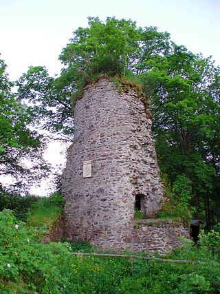
The Königsburg is a ruined medieval castle southeast of Königshütte, a village in the borough of Oberharz am Brocken, in Harz district in the German state of Saxony-Anhalt.

Blankenburg (Harz) is a town and health resort in the district of Harz in Saxony-Anhalt, Germany, at the north foot of the Harz Mountains, 12 miles (19 km) southwest of Halberstadt.

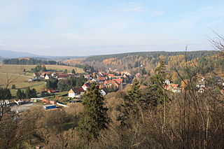
Elbingerode is an Ortsteil of Oberharz am Brocken in the Harz district, in the German state of Saxony-Anhalt. The former town was incorporated into the newly established municipality on 1 January 2010. Its population is 3,101 (2021).

Derenburg is a town in the district of Harz, in Saxony-Anhalt, Germany. Since 1 January 2010, it has been part of the Blankenburg am Harz municipality. Its population is 2,466 (2021).
Neudorf is a village and a former municipality in the district of Harz, in Saxony-Anhalt, Germany. Since 1 September 2010, it is part of the town Harzgerode.
Blankenburg was a Verwaltungsgemeinschaft in the district of Harz, in Saxony-Anhalt, Germany. The seat of the Verwaltungsgemeinschaft was in Blankenburg am Harz. It was disbanded on 1 January 2010.
The County of Regenstein was a mediaeval statelet of the Holy Roman Empire. It was ruled by the Saxon comital House of Regenstein, named after their residence at Regenstein Castle near Blankenburg north of the Harz mountain range.

The Harzer Wandernadel is a system of hiking awards in the Harz mountains in central Germany. Hikers can earn awards at different levels of challenge by walking to the various checkpoints in the network and stamping their passbooks to record the visit. With 222 checkpoints in three federal states and across five districts in the Harz and with membership in five figures, the system has gained a following Germany-wide.

The Wolfsklippen, also called the Wolfsklippe, is a granite mountain in the Harz mountains in Central Germany with an observation platform on the summit. Its height is frequently given as about 723 m above sea level (NN), but occasionally also as only around 710 m above NN.
Torfhaus is a village in the borough of the mining town of Altenau in the Harz mountains of Germany and lies at a height of about 800 m above sea level (NN). It is the highest settlement in Lower Saxony.
The Stapenberg is a 443-metre-high (1,453 ft) hill spur in the Harz Mountains of central Germany in Harz district in the federal state of Saxony-Anhalt.
Königshütte is a German village in the district of Harz, in the state of Saxony-Anhalt. Since 1 January 2010 is a part of the municipality of Oberharz am Brocken. Its population is 452 (2021).
Trautenstein is a village in the borough of Oberharz am Brocken in the district of Harz in the German state of Saxony-Anhalt. Formerly an independent municipality, it was merged into the town Hasselfelde in 2002, which was merged into Oberharz am Brocken in 2010. Its population is 390 (2021).

Heimburg Castle, also called the Altenburg or Alteburg, is a ruined castle on an oval hilltop about 330 metres above sea level (NN) which is located just north of the Harz Mountains in central Germany. The ruins of this hilltop castle stand above the village of Heimburg in the borough of Blankenburg in the district of Harz in the state of Saxony-Anhalt. It is checkpoint no. 84 in the Harzer Wandernadel hiking network.

the Regenstein family, also Reinstein, was a Lower Saxon noble family, which was named after the eponymous Regenstein Castle near Blankenburg on the edge of the Harz Mountains of central Germany.

The Selke is a river of Saxony-Anhalt, Germany.

The Trudenstein is a rock formation and popular hiker's destination in the Harz Mountains of central Germany. It is located in the federal state of Saxony-Anhalt.

The Ziegenberg is a low ridge between the villages of Benzingerode and Heimburg on the northern edge of the Harz Mountains in central Germany. The ridge is a designated nature reserve. The reserve has an area of 88.4 hectares and has a variety of habitats including mesophytic grassland (Halbtrockenrasen), bushes, pine woods and wet meadows. Its highest points are the eponymous Ziegenberg and the Struvenberg

The Struvenburg was a medieval castle immediately east of Benzingerode, a village in the borough of Wernigerode in the district of Harz in the German state of Saxony-Anhalt. Today only a few earthworks remain. Very little is known about this castle. The name may be derived from the adjective struf = scrubby or rough.
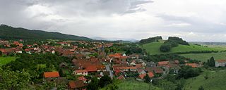
Benzingerode has been a village incorporated into the borough of Wernigerode since 1 April 1993. in the district of Harz in the German state of Saxony-Anhalt.


