Elbingerode

Last updated
Elbingerode
Elbingerode.jpg
Wappen Elbingerode (Harz).png
Elbingerode within Oberharz am Brocken
Elbingerode in Oberharz am Brocken.svg
Germany adm location map.svg
Red pog.svg
Elbingerode
Saxony-Anhalt location map.svg
Red pog.svg
Elbingerode
Coordinates: 51°46′10″N10°48′11″E / 51.76944°N 10.80306°E / 51.76944; 10.80306 Coordinates: 51°46′10″N10°48′11″E / 51.76944°N 10.80306°E / 51.76944; 10.80306
Country Germany
State Saxony-Anhalt
District Harz
Town Oberharz am Brocken
Area
  Total80.74 km2 (31.17 sq mi)
Elevation
500 m (1,600 ft)
Population
 (2006-12-31)
  Total5,591
  Density69/km2 (180/sq mi)
Time zone UTC+01:00 (CET)
  Summer (DST) UTC+02:00 (CEST)
Postal codes
38875
Dialling codes 039454
Website www.elbingerode.de

Elbingerode is an Ortsteil of Oberharz am Brocken in the Harz district, in the German state of Saxony-Anhalt. The former town was incorporated into the newly established municipality on 1 January 2010.

Contents

Geography

It is situated in the eastern Harz mountain range, approximately 8 km (5.0 mi) south of neighbouring Wernigerode. The former municipal area comprised Elbingerode proper as well as the villages of Königshütte and Rübeland. The surrounding mountains were the site of numerous ore mines and ironworks, today the Drei Kronen & Ehrt mine and the Büchenberg Pit, run as show mines, are popular tourist destinations.

Cargo train service to several surrounding limestone pits is provided on the standard gauge Rübeland Railway link to Blankenburg, opened in 1886; the former continuation to Drei Annen Hohne station and the Harz Railway line was closed in 1965.

There is a large open-cast limestone mine, the Tagebau Felswerke, on the edge of the town. From checkpoint 39 on the Harzer Wandernadel hiking network, there is a good view over the mine. [1]

History

The lands around Elbingerode had been a feudal hunting ground since the Middle Ages, when it was part of the Harzgau territory within the Duchy of Saxony. King Henry the Fowler stayed several times at Bodfeld, a royal hunting lodge or Königspfalz , demonstrably in 935, as did his successors of the Ottonian and Salian dynasty. In 1056 Emperor Henry III died here on 5 October 1056 on a hunting excursion with Pope Victor II.

The settlement itself was first mentioned as Alvelingeroth in a 1206 deed, when Pope Innocent III granted the estates to the canonesses of Gandersheim Abbey. In 1422 Abbess Agnes of Brunswick ceded Elbingerode to her father, the Welf duke Eric I of Brunswick-Grubenhagen, who vested Count Bodo VII of Stolberg with the Elbingerode mines and Wildbannforst hunting grounds five years later. Nevertheless, Bodo chose to give the remote estates in pawn to his brothers-in-law, the Counts of Schwarzburg, in 1438. His descendants, deep in debt, were not able to redeem the pledge.

Elbingerode, engraving by Matthaus Merian (about 1650) Elbingerrode-1654-Merian.jpg
Elbingerode, engraving by Matthäus Merian (about 1650)

Finally in 1564, the Brunswick dukes of Calenberg seized the fief and granted town privileges to the citizens of Elbingerode, which became the seat of a local Amt administration. The Stolberg counts had vainly attempted to regain the estates; their claims were finally rejected by Duke George of Brunswick-Calenberg in 1635. With the Calenberg principality, Elbingerode became part of the newly established Electorate of Hanover in 1705. Temporarily part of the Napoleonic Kingdom of Westphalia, the Amt passed to the Welf Kingdom of Hanover in 1814. Annexed by Prussia after the Austro-Prussian War of 1866, it was incorporated into the Province of Hanover.

In 1932 Elbingerode passed to the Ilfeld district in the Prussian Province of Saxony; it became part of the Soviet occupation zone and East Germany after World War II. In 2010, Elbingerode, with Rübeland and Königshütte, merged with the neighbouring towns of Benneckenstein and Hasselfelde as well as the municipalities of Elend, Sorge, Stiege, and Tanne into the town of Oberharz am Brocken.

Notable people

International relations

Elbingerode is twinned with:

Related Research Articles

<span class="mw-page-title-main">Harz</span> Low mountain range in northern Germany

The Harz is a highland area in northern Germany. It has the highest elevations for that region, and its rugged terrain extends across parts of Lower Saxony, Saxony-Anhalt, and Thuringia. The name Harz derives from the Middle High German word Hardt or Hart. The name Hercynia derives from a Celtic name and could refer to other mountain forests, but has also been applied to the geology of the Harz. The Brocken is the highest summit in the Harz with an elevation of 1,141.1 metres (3,744 ft) above sea level. The Wurmberg is the highest peak located entirely within the state of Lower Saxony.

<span class="mw-page-title-main">Königsburg</span> Ruined medieval castle

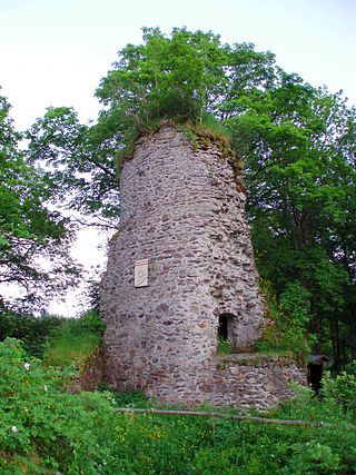
The Königsburg is a ruined medieval castle southeast of Königshütte, a village in the borough of Oberharz am Brocken, in Harz district in the German state of Saxony-Anhalt.

<span class="mw-page-title-main">Blankenburg (Harz)</span> Town in Saxony-Anhalt, Germany

Blankenburg (Harz) is a town and health resort in the district of Harz, in Saxony-Anhalt, Germany, at the north foot of the Harz Mountains, 12 miles (19 km) southwest of Halberstadt.

<span class="mw-page-title-main">Sankt Andreasberg</span> Stadtteil of Braunlage in Lower Saxony, Germany

Sankt Andreasberg is a former town in the district of Goslar, in Lower Saxony, Germany. Since 1 November 2011, it is part of the town Braunlage. It is situated in the Harz, approximately 7 km west of Braunlage proper, and 20 km east of Osterode am Harz.

<span class="mw-page-title-main">Benneckenstein</span> Stadtteil of Oberharz am Brocken in Saxony-Anhalt, Germany

Benneckenstein is a town in the district of Harz, in Saxony-Anhalt, Germany. Since 1 January 2010, it has been part of the town of Oberharz am Brocken. Benneckenstein is in the eastern Harz, 14 km southeast of Braunlage, and 24 km south of Wernigerode.

<span class="mw-page-title-main">Elend, Saxony-Anhalt</span> Stadtteil of Oberharz am Brocken in Saxony-Anhalt, Germany

Elend is a district of the town of Oberharz am Brocken in the Harz District, in Saxony-Anhalt, Germany. It lies in the Bode valley in the High Harz in central Germany, at a height of 505 m above NN. This part of the valley is known locally as Elendstal. Elend is located near the former Inner German Border between West and East Germany.

<span class="mw-page-title-main">Hohnekamm</span> Mountain ridge in Central Germany

The Hohnekamm or Hohne Kamm is a mountain ridge up to 900 m above sea level high in the Harz mountains of central Germany. It is located in the state of Saxony-Anhalt, and is well known for its rock towers or tors, the Hohneklippen.

<span class="mw-page-title-main">Harzer Hexenstieg</span>

The Harz Witches' Trail is a footpath, just under 100 km long, in Germany that runs from Osterode through the Harz mountains and over its highest peak, the Brocken, to Thale. It is a project by the Harz Transport Association and Harz Club and is part of the system of trails known as the Harzer Wandernadel.

<span class="mw-page-title-main">Rübeland</span> Village in Saxony-Anhalt, Germany

Rübeland is a village in the district of Harz in the German state of Saxony-Anhalt. Since 2004, it has been given the additional description of Höhlenort. The sub-districts of Rübeland are Susenburg, Kaltes Tal, Kreuztal and Neuwerk. Since 1 January 2010, it is part of the town Oberharz am Brocken and has 959 inhabitants.

<span class="mw-page-title-main">Königshütte (Harz)</span>

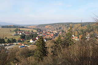
Königshütte is a German village in the district of Harz, in the state of Saxony-Anhalt. Since 1 January 2010 is a part of the municipality of Oberharz am Brocken.

<span class="mw-page-title-main">Oberharz am Brocken</span> Town in Saxony-Anhalt, Germany

Oberharz am Brocken is a town in the Harz District, in Saxony-Anhalt, Germany. It was formed on 1 January 2010 by the merger of the town of Elbingerode with the municipalities of the former Verwaltungsgemeinschaft Brocken-Hochharz.

<span class="mw-page-title-main">Drei Annen Hohne</span>

Drei Annen Hohne is the name of a small settlement within the municipal area of Wernigerode in Saxony-Anhalt, Germany.

<span class="mw-page-title-main">Trautenstein</span> Ortsteil of Oberharz am Brocken in Saxony-Anhalt, Germany

Trautenstein is a village in the borough of Oberharz am Brocken in the district of Harz in the German state of Saxony-Anhalt. Trautenstein has 493 inhabitants as of 1 January 2010. Formerly an independent municipality, it was merged into the town Hasselfelde in 2002, which was merged into Oberharz am Brocken in 2010.

<span class="mw-page-title-main">Bodfeld</span>

Bodfeld was a small royal palace or lodge that was primarily established for hunting purposes and, when the town of Elbingerode emerged, for the administration of ore mining in the central Harz that underpinned the power of the Ottonian and Salian kings and emperors in medieval Europe. The term Bodfeld is also used to describe an area of forest that lies predominantly south of Elbingerode.

<span class="mw-page-title-main">Königshütte Waterfall</span>

Königshütte Waterfall is a waterfall in the village of Königshütte in the borough of Oberharz am Brocken in the Harz Mountains of Central Germany.

<span class="mw-page-title-main">Dreieckiger Pfahl</span>

The Dreieckige Pfahl is a historic boundary stone, about 1.35 metres high and made of granite, located southwest of the Brocken, the highest mountain in the Harz Mountains of central Germany. The stone, erected before 1866, marked the border between the Kingdom of Hanover and the Duchy of Brunswick. Originally this spot was a tripoint. During the division of Germany the border between the German Democratic Republic and the Federal Republic of Germany ran past the Dreieckiger Pfahl. Today it marks the border between the states of Saxony-Anhalt and Lower Saxony, the post lying just within the Lower Saxon side. During the Cold War it was accessible from the west.

<span class="mw-page-title-main">Ilsestein</span> Prominent granite rock formation near Ilsenburg, Harz, Germany

The Ilsestein is a prominent granite rock formation near the town of Ilsenburg in the Harz mountains of central Germany. Offering a scenic view over the Ilse valley to the Brocken massif, the highest mountain of the range, it is today a popular tourist destination.

<span class="mw-page-title-main">Ahrentsklint</span>

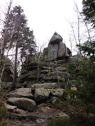
The Ahrensklint or Ahrentsklint in the Harz Mountains is a granite rock formation, 822.4 m above sea level (NN), on the Erdbeerkopf in Harz district in the German state of Saxony-Anhalt.

<span class="mw-page-title-main">Drei Kronen & Ehrt</span> Mine in Germany

Drei Kronen & Ehrt is a former mine in the Harz Mountains of central Germany. It is located in the parish of Elbingerode in the county of Harz (Saxony-Anhalt). The mine extracted pyrite. Since 1992 it has been used, albeit not continuously, as a visitor mine.

<span class="mw-page-title-main">Büchenberg Pit</span>

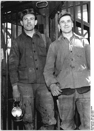
The Büchenberg Pit is an old iron ore mine in the Harz Mountains of Germany that is operated today as a show mine. It is located in the village of Büchenberg in the municipality of Oberharz am Brocken in the state of Saxony-Anhalt.

References

  1. Stempelstelle 39 / Tagebau Felswerke at www.harzer-wandernadel.de. Retrieved 1 Nov 2017.