
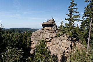
The Ferdinandstein is a prominent rock in the Harz National Park in central Germany
The Ferdinandstein is a prominent rock in the Harz National Park in central Germany
The Ferdinandstein lies at an elevation of 648 metres above sea level near Plessenburg in the borough of Wernigerode in the Harz Mountains. [1]
The rock is a granite boulder that is a typical product of spheroidal weathering. [1]
The rock is inscribed with the words "Ferdinands Stein". Behind it on a smaller rock embedded in the ground is the inscription "Hier schoss Ferdinand Graf zu Stolberg Wernigerode am 23ten Merz 1798 einen Wolf" ("Here Ferdinand, Count of Stolberg- Wernigerode shot a wolf on 23 March 1798"). [1] This was the last wolf living in the wild that was shot by the Count. [2]
The rock is checkpoint no. 16 in the Harzer Wandernadel hiking network. [2]

Ilsenburg is a town in the district of Harz, in Saxony-Anhalt in Germany. It is situated under the north foot of the Harz Mountains, at the entrance to the Ilse valley with its little river, the Ilse, a tributary of the Oker, about six 6 miles (9.7 km) north-west of the town of Wernigerode. It received town privileges in 1959. Owing to its surrounding of forests and mountains as well as its position on the edge of the Harz National Park, Ilsenburg is a popular tourist resort. Since 2002, it is officially an air spa.

Elbingerode is an Ortsteil of Oberharz am Brocken in the Harz district, in the German state of Saxony-Anhalt. The former town was incorporated into the newly established municipality on 1 January 2010. Its population is 3,101 (2021).

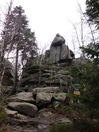
The Zeterklippen are a striking rock formation or tor on the 930-metre-high Renneckenberg mountain, overlooking the Ilse valley in the Harz mountains in Germany. The Renneckenberg is an eastern sub-peak of the Brocken. The rocks themselves lie at a height of about 830 metres (2,720 ft) above sea level. They can be reached from the Molkenhausstern after about 2.5 km. The track initially runs uphill through dense spruce forest until the view opens out towards the Hohnekamm and down to Wernigerode. Then the route branches off to the right onto a steep, 0.5 km, path and, after about 200 m, a gentler 0.4 km path leads to the Große Zeterklippe. Immediately below this highest of the rocks is a mountain hut that dates to the time when a botanical garden had been laid out here as a replacement for the inaccessible Brockengarten.

The Heinrichshöhe is a subsidiary peak of the highest mountain in the Harz, the Brocken, and, at 1,040 m above NN, it is the second summit in the Harz Mountains.

The Wolfsklippen, also called the Wolfsklippe, is a granite mountain in the Harz mountains in Central Germany with an observation platform on the summit. Its height is frequently given as about 723 m above sea level (NN), but occasionally also as only around 710 m above NN.

The Bear Monument is a monument to bears in the Harz mountains of central Germany. It stands by a forest track and walking trail in woods not far from the Bremer Teich and the Viktorshöhe hill and marks the spot where the last bear was killed in 1696 in the Anhalt Forest. The monument was erected around 1900. It is a glacial erratic boulder on which a cast-iron memorial plate with an inscription has been affixed. Next to the bear monument is a checkpoint which is part of the Harzer Wandernadel network of hiking trails.
The Ottofels, named after Prince Otto of Stolberg-Wernigerode, is a tor and natural monument near Wernigerode in the Harz mountains of central Germany.

Drei Annen Hohne is the name of a small settlement within the municipal area of Wernigerode in Saxony-Anhalt, Germany.

Plessenburg is a village in the town of Ilsenburg in the Harz National Park, in the district of Harz in the German state of Saxony-Anhalt.
The Molkenhaus is a historic house near Wernigerode, Harz, Germany, located on the Jägerkopf hill above the Steinerne Renne waterfall and the source region of the Holtemme river. The timber-framed building, which was built by order of the Senior Master Hunter (Oberjägermeister) of the counts of Stolberg, von Meseberg, at the beginning of the 18th century, belonged to the Ilsenburger Marienhof and was used for hunting purposes and the production of butter. Nowadays it is used by the Harz National Park.

Sophienhof is a village in the municipality of Ilfeld in the district of Nordhausen in the German federal state of Thuringia.

The Christianental is a side valley of the Mühlental in the borough of Wernigerode in the Harz Mountains of central Germany. It lies between the Agnesberg, the hill on which Wernigerode Castle stands, and the Fenstermacherberg. The Christianental is known countrywide for its wildlife park, the forest restaurant at the head of the valley along with the indoor shooting range (Schützenhaus) and the master fisherman's house (Fischmeisterhaus) and neighbouring forester's lodge at the bottom of the valley. The latter was featured in the title of the novel Das Forsthaus im Christianental by Käthe Papke.

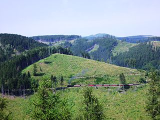
The Ilse valley is the ravine of the Ilse stream in the northern boundary of the Harz mountain range in Germany. Part of the Harz National Park, it runs from the town of Ilsenburg at the foot of the mountain range up to the source region near the summit of the Brocken massif, the highest mountain of the range. The scenic valley is a popular hiking area.

The Ilsestein is a prominent granite rock formation near the town of Ilsenburg in the Harz mountains of central Germany. Offering a scenic view over the Ilse valley to the Brocken massif, the highest mountain of the range, it is today a popular tourist destination.
The Eckerloch is a forested mountain valley, 845 metres above sea level near the village of Schierke in the Harz Mountains of central Germany.
The Ahrensklint or Ahrentsklint in the Harz Mountains is a granite rock formation, 822.4 m above sea level (NN), on the Erdbeerkopf in Harz district in the German state of Saxony-Anhalt.
Am Kruzifix is an ancient forest landmark in the Harz Mountains of Germany. Today it is recalled by an iron cross or crucifix at the junction of several hiking trails.

The Helenenruh is a 629 metre high rocky ridge near the village of Elend in the Harz Mountains of central Germany.
The Elversstein in the Harz Mountains of Germany is a granite rock formation with a maximum elevation of 499 m above sea level (NN) on the Steinberg near Hasserode in the county of Harz in Saxony-Anhalt.
The Hunrodeiche or, more rarely, the Hunrodseiche, in the Harz Mountains of central Germany is an oak tree over 1,000 years old near Hainfeld in the county of Mansfeld-Südharz in the state of Saxony-Anhalt.