Related Research Articles

Ilsenburg is a town in the district of Harz, in Saxony-Anhalt in Germany. It is situated under the north foot of the Harz Mountains, at the entrance to the Ilse valley with its little river, the Ilse, a tributary of the Oker, about six 6 miles (9.7 km) north-west of the town of Wernigerode. It received town privileges in 1959. Owing to its surrounding of forests and mountains as well as its position on the edge of the Harz National Park, Ilsenburg is a popular tourist resort. Since 2002, it is officially an air spa.

The Harzer Wandernadel is a system of hiking awards in the Harz mountains in central Germany. Hikers can earn awards at different levels of challenge by walking to the various checkpoints in the network and stamping their passbooks to record the visit. With 222 checkpoints in three federal states and across five districts in the Harz and with membership in five figures, the system has gained a following Germany-wide.

Auf dem Acker is a mountain ridge up to 865.1 m (2,838 ft) high, which is located in the southwestern part of the Harz mountains in Lower Saxony (Germany).
The Taubenklippe is a rock formation in the Harz mountains in the German state of Saxony-Anhalt. It lies about halfway between Bad Harzburg and Ilsenburg at a height of 572 m above NN on the eastern slopes of the Ecker valley. From the crag there is a good view over Harz Foreland, the heights near Bad Harzburg and the highest mountain in the Har, the Brocken. The Taubenklippe may be reached from the Ecker valley on a footpath, some 6 km long, that starts in Ilsenburg.

The Froschfelsen, also called the Froschsteinklippe, is a natural monument near Ilsenburg in the northern Harz in central Germany. It is a formation of granite rocks that take the shape of a frog, hence the name.
The Molkenhaus is a historic house near Wernigerode, Harz, Germany, located on the Jägerkopf hill above the Steinerne Renne waterfall and the source region of the Holtemme river. The timber-framed building, which was built by order of the Senior Master Hunter (Oberjägermeister) of the counts of Stolberg, von Meseberg, at the beginning of the 18th century, belonged to the Ilsenburger Marienhof and was used for hunting purposes and the production of butter. Nowadays it is used by the Harz National Park.

The Bremen Hut in the Harz Mountains is a refuge hut and shelter in that part of the Harz National Park lying within the borough of Ilsenburg (Harz) in Harz district in the German state of Saxony-Anhalt.

The Ilse valley is the ravine of the Ilse stream in the northern boundary of the Harz mountain range in Germany. Part of the Harz National Park, it runs from the town of Ilsenburg at the foot of the mountain range up to the source region near the summit of the Brocken massif, the highest mountain of the range. The scenic valley is a popular hiking area.

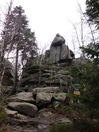
The Ilsestein is a prominent granite rock formation near the town of Ilsenburg in the Harz mountains of central Germany. Offering a scenic view over the Ilse valley to the Brocken massif, the highest mountain of the range, it is today a popular tourist destination.
The Ahrensklint or Ahrentsklint in the Harz Mountains is a granite rock formation, 822.4 m above sea level (NN), on the Erdbeerkopf in Harz district in the German state of Saxony-Anhalt.

The Ferdinandstein is a prominent rock in the Harz National Park in central Germany
The Kapitelsberg in the Harz Mountains of Germany is a hill, 535.7 m above sea level (NN), near the village of Tanne in the county of Harz, Saxony-Anhalt.

The Helenenruh is a 629 metre high rocky ridge near the village of Elend in the Harz Mountains of central Germany.
The Drei-Länder-Stein is a boundary stone at the tripoint of the German federal states of Lower Saxony, Saxony-Anhalt and Thuringia near the Großer Ehrenberg mountain in the Harz.
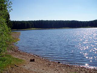
The Jägersbleeker Teich in the Harz Mountains of central Germany is a storage pond near the town of Clausthal-Zellerfeld in the county of Goslar in Lower Saxony. It is one of the Upper Harz Ponds that were created for the mining industry.
The Heibeeksköpfe in the Harz Mountains of central Germany are a double summit with a maximum height of 465.2 m above sea level (NN), near Bad Lauterberg in the unincorporated area of Harz in the district of Göttingen in Lower Saxony.

A Köte is the term used in the Harz Mountains of central Germany for a charcoal burner's hut (Köhlerhütte). A Köte was occupied by a charcoal burner in order to look after a nearby wood pile (Kohlenmeiler). The charcoal burner prepared the necessary charcoal for the smelting of ores.

The Stierbergsteich in the Harz Mountains of central Germany is a storage pond near Rothesütte on the boundary of the counties of Harz (Saxony-Anhalt) and Nordhausen (Thuringia).
The Jagdkopf a hill, 603.1 m above sea level (NN) high, in the Harz Mountains of Germany. It is located between the villages of Wieda and Zorge in the unincorporated area of Harz in the district of Göttingen in the state of Lower Saxony.

The Kalte Birke is a cross tracks in the Harz Mountains of Germany where there is a refuge hut and former settlement. It is located west of the Innerste Reservoir at about 540 metres above sea level. It lies in the unincorporated area of Harz in the county of Goslar. Historically it is closely linked to the municipality of Hahausen and village of Neuekrug, four kilometres northwest.