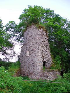
The Königsburg is a ruined medieval castle southeast of Königshütte, a village in the borough of Oberharz am Brocken, in Harz district in the German state of Saxony-Anhalt.

Elbingerode (Harz) is a district of Oberharz am Brocken in the Harz district, in the German state of Saxony-Anhalt. The former town was incorporated into the newly established municipality on 1 January 2010.

The Stapenberg is a 443-metre-high (1,453 ft) hill spur in the Harz Mountains of central Germany in Harz district in the federal state of Saxony-Anhalt.
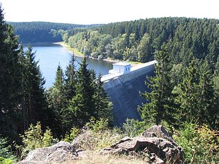
The Zillierbach Dam lies in the East Harz in the German state of Saxony-Anhalt near the town of Elbingerode (Harz) and impounds the Zillierbach stream. It supplies drinking water to several villages in the High Harz as well as the town of Wernigerode; it also provides flood protection.

Drei Annen Hohne is the name of a small settlement within the municipal area of Wernigerode in Saxony-Anhalt, Germany.
Bodfeld was a small royal palace or lodge that was primarily established for hunting purposes and, when the town of Elbingerode was emerged, for the administration of ore mining in the central Harz that underpinned the power of the Ottonian and Salian kings and emperors in medieval Europe. The term Bodfeld is also used to describe an area of forest that lies predominantly south of Elbingerode.
The Trageburg is a ruined castle immediately next to the Rappbode Pre-Dam in the Harz Mountains of Germany. It is located near Trautenstein in the district of Harz in Saxony-Anhalt.

The Dreieckige Pfahl is an historic boundary stone, about 1.35 metres high and made of granite, located southwest of the Brocken, the highest mountain in the Harz Mountains of central Germany. The stone, erected before 1866, marked the border between the Kingdom of Hanover and the Duchy of Brunswick. Originally this spot was a tripoint. During the division of Germany the border between the German Democratic Republic and the Federal Republic of Germany ran past the Dreieckiger Pfahl. Today it marks the border between the states of Saxony-Anhalt and Lower Saxony, the post lying just within the Lower Saxon side. During the Cold War it was accessible from the west.

The Bremen Hut in the Harz Mountains is a refuge hut and shelter in that part of the Harz National Park lying within the borough of Ilsenburg (Harz) in Harz district in the German state of Saxony-Anhalt.
The Eckerloch is a forested mountain valley, 845 metres above sea level near the village of Schierke in the Harz Mountains of central Germany.
The Kapitelsberg in the Harz Mountains of Germany is a hill, 535.7 m above sea level (NN), near the village of Tanne in the county of Harz, Saxony-Anhalt.
The Drei-Länder-Stein is a boundary stone at the tripoint of the German federal states of Lower Saxony, Saxony-Anhalt and Thuringia near the Großer Ehrenberg mountain in the Harz.
The Ölbergshöhe in the Harz Mountains of central Germany is a mountain spur, 320.6 m, of the Ramberg ridge near Bad Suderode in the Saxony-Anhalt county of Harz.

The Hunrodeiche or, more rarely, the Hunrodseiche, in the Harz Mountains of central Germany is an oak tree over 1,000 years old near Hainfeld in the county of Mansfeld-Südharz in the state of Saxony-Anhalt.

The Heibeeksköpfe in the Harz Mountains of central Germany are a double summit with a maximum height of 465.2 m above sea level (NN), near Bad Lauterberg in the unincorporated area of Harz in the district of Göttingen in Lower Saxony.

A Köte is the term used in the Harz Mountains of central Germany for a charcoal burner's hut (Köhlerhütte). A Köte was occupied by a charcoal burner in order to look after a nearby wood pile (Kohlenmeiler). The charcoal burner prepared the necessary charcoal for the smelting of ores.
The Dehnenkopf in the Harz Mountains of central Germany is a summit about 775 m above sea level (NN) near Torfhaus in the unincorporated area of Harz in the county of Goslar in Lower Saxony.

The Stierbergsteich in the Harz Mountains of central Germany is a storage pond near Rothesütte on the boundary of the counties of Harz (Saxony-Anhalt) and Nordhausen (Thuringia).

The Sandlünz is a hill in the Harz Mountains of Germany. It is 516.2 m above sea level (NN) and located near Netzkater in the county of Nordhausen in the state of Thuringia.
The Jagdkopf a hill, 603.1 m above sea level (NN) high, in the Harz Mountains of Germany. It is located between the villages of Wieda and Zorge in the unincorporated area of Harz in the district of Göttingen in the state of Lower Saxony.
