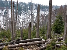
The Eckerloch is a forested mountain valley, 845 metres above sea level near the village of Schierke in the Harz Mountains of central Germany. [1]
The Eckerloch is a forested mountain valley, 845 metres above sea level near the village of Schierke in the Harz Mountains of central Germany. [1]
The Eckerloch valley runs downhill from northwest to southeast and lies about 1½ kilometres due south of the highest mountain in the Harz, the Brocken. Its small unnamed stream runs into the Cold Bode To the west is the mountain of Königsberg (1,033 metres) with a long southeast-running ridge with several crags and tors. To the east is the Heinrichshöhe (1,039 metres) a southeast spur of the Brocken massif. [2]
The Eckerloch was the site of one of several Harz granite quarries in the vicinity of Schierke.
In the 1920s the locals built the first ski jump on the Eckerloch, with the permission of the chamber of the prince of Stolberg-Wernigerode. The site was chosen due to it good snow conditions after the ski jump on the southern slopes of the Erdbeerkopf had been abandoned. It became one of the well-known jumps in the Harz. [1]
In 1950 the first East German ski jumping championships took place here on a new jump, but it was soon abandoned due to its proximity to the Inner German Border and was demolished in the 1970s. [1]
The Brocken Railway had a station built here for the ski jumping championships, but it was closed immediately afterwards and is now just a request stop. After a tight left hand bend before the Eckerloch Bridge and another right-hander, the line reaches Goetheweg station (956 m), which is now only used as a locomotive depot.
The Eckerloch is on one of the most scenic hiking trails in the Harz. The Old Königsberg Way (alte Königsbergweg), one of two trails that ran to the top of the Königsberg mountain, began near Eckerloch and ran uphill, alongside the old Königsberg Quarry, up to the Kanzelklippen crags. From there it ran over the Rabenklippe, the old Eckerloch ski jump, towards the Kesselklippe and then through the Goethe Moor to the station at Goetheweg. It ran along the entire ridge to the Hirschhornklippen .
There is a rest area here along with a checkpoint here (No. 11) in the Harzer Wandernadel hiking system.

The Wurmberg Gondola Lift is a monocable gondola lift with a length of 1.7 miles (2.7 km), built in 1963, leading from the Braunlage tourist resort within the Harz mountain range on the top of the 3,185 feet (971 m) high Wurmberg mountain.

Sankt Andreasberg is a former town in the district of Goslar, in Lower Saxony, Germany. Since 1 November 2011, it is part of the town Braunlage. It is situated in the Harz, approximately 7 km west of Braunlage proper, and 20 km east of Osterode am Harz.

Schierke is a village and a former municipality in the Harz district, in the German state of Saxony-Anhalt. Since 1 July 2009, it is part of the town Wernigerode. Situated within the Harz mountain range in the valley of the river Bode, at the rim of the Harz National Park, it is mainly a tourist resort, especially for hiking and all kinds of winter sports.
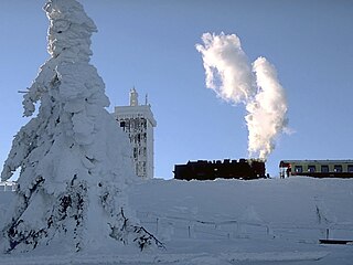
The Brocken Railway is one of three tourist metre gauge railways which together with the Harz Railway and Selke Valley Railway form the Harz Narrow Gauge Railways railway network in the Harz mountain range of Germany.

The Königsberg is a neighbouring peak of the Brocken and, at 1033.5 m above sea level the third highest elevation in the Harz mountains. It lies on a long ridge that runs from southeast to northwest about 1.5 km south of the Brocken's summit. Near its summit on the northwest side is the rock formation of Hirschhörner. To the east the land descends to the Schwarze Schluftwasser, a small tributary of the Kalte Bode which flows south of the mountain. To the east on the far side of the Schwarzer Schluftwasser is the Heinrichshöhe, another subpeak of the Brocken.

The Heinrichshöhe is a subsidiary peak of the highest mountain in the Harz, the Brocken, and, at 1,040 m above NN, it is the second summit in the Harz Mountains.

The Hohnekamm or Hohne Kamm is a mountain ridge up to 900 m above sea level high in the Harz mountains of central Germany. It is located in the state of Saxony-Anhalt, and is well known for its rock towers or tors, the Hohneklippen.

Drei Annen Hohne is the name of a small settlement within the municipal area of Wernigerode in Saxony-Anhalt, Germany.

The Renneckenberg is a mountain, roughly 933 metres (3,061 ft) high, in the High Harz part of the Harz mountain range of central Germany within the borough of Wernigerode in the state of Saxony-Anhalt.

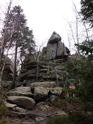
The Rabenklippe is a granite rock formation in the Harz National Park. The name means "Raven Crag" and is very apt as ravens live in the vicinity.

The Trudenstein is a rock formation and popular hiker's destination in the Harz Mountains of central Germany. It is located in the federal state of Saxony-Anhalt.

Schnarcherklippen is the name of a rock formation south of the village of Schierke in the High Harz mountains of Saxony-Anhalt in central Germany. The name translates roughly to "snoring crags" or "snoring rocks".

The Dreieckige Pfahl is a historic boundary stone, about 1.35 metres high and made of granite, located southwest of the Brocken, the highest mountain in the Harz Mountains of central Germany. The stone, erected before 1866, marked the border between the Kingdom of Hanover and the Duchy of Brunswick. Originally this spot was a tripoint. During the division of Germany the border between the German Democratic Republic and the Federal Republic of Germany ran past the Dreieckiger Pfahl. Today it marks the border between the states of Saxony-Anhalt and Lower Saxony, the post lying just within the Lower Saxon side. During the Cold War it was accessible from the west.

The Bremen Hut in the Harz Mountains is a refuge hut and shelter in that part of the Harz National Park lying within the borough of Ilsenburg (Harz) in Harz district in the German state of Saxony-Anhalt.

The Ilse valley is the ravine of the Ilse stream in the northern boundary of the Harz mountain range in Germany. Part of the Harz National Park, it runs from the town of Ilsenburg at the foot of the mountain range up to the source region near the summit of the Brocken massif, the highest mountain of the range. The scenic valley is a popular hiking area.
The Ahrensklint or Ahrentsklint in the Harz Mountains is a granite rock formation, 822.4 m above sea level (NN), on the Erdbeerkopf in Harz district in the German state of Saxony-Anhalt.

The Barenberg, also called the Bärenberg or Bärenkopf, is a mountain, 695.5 m above sea level (NN), in the Harz Mountains of Germany near the village of Schierke, Harz county, in the state of Saxony-Anhalt.
Am Kruzifix is an ancient forest landmark in the Harz Mountains of Germany. Today it is recalled by an iron cross or crucifix at the junction of several hiking trails.
The Kapitelsberg in the Harz Mountains of Germany is a hill, 535.7 m above sea level (NN), near the village of Tanne in the county of Harz, Saxony-Anhalt.

The Helenenruh is a 629 metre high rocky ridge near the village of Elend in the Harz Mountains of central Germany.