
The Harz is a highland area in northern Germany. It has the highest elevations for that region, and its rugged terrain extends across parts of Lower Saxony, Saxony-Anhalt, and Thuringia. The name Harz derives from the Middle High German word Hardt or Hart. The name Hercynia derives from a Celtic name and could refer to other mountain forests, but has also been applied to the geology of the Harz. The Brocken is the highest summit in the Harz with an elevation of 1,141.1 metres (3,744 ft) above sea level. The Wurmberg is the highest peak located entirely within the state of Lower Saxony.
Harz National Park is a nature reserve in the German federal states of Lower Saxony and Saxony-Anhalt. It comprises portions of the western Harz mountain range, extending from Herzberg and Bad Lauterberg at the southern edge to Bad Harzburg and Ilsenburg on the northern slopes. 95% of the area is covered with forests, mainly with spruce and beech woods, including several bogs, granite rocks and creeks. The park is part of the Natura 2000 network of the European Union.
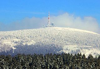
The Brocken, also sometimes referred to as the Blocksberg, is the highest peak in the Harz mountain range and also the highest peak in Northern Germany; it is near Schierke in the German state of Saxony-Anhalt between the rivers Weser and Elbe. Although its elevation of 1,141 metres (3,743 ft) is below alpine dimensions, its microclimate resembles that of mountains of about 2,000 m (6,600 ft). The peak above the tree line tends to have a snow cover from September to May, and mists and fogs shroud it up to 300 days of the year. The mean annual temperature is only 2.9 °C (37.2 °F). It is the easternmost mountain in northern Germany; travelling east in a straight line, the next prominent elevation would be in the Ural Mountains in Russia.

Sankt Andreasberg is a former town in the district of Goslar, in Lower Saxony, Germany. Since 1 November 2011, it is part of the town Braunlage. It is situated in the Harz, approximately 7 km west of Braunlage proper, and 20 km east of Osterode am Harz.

Altenau is a town and a former municipality in the district of Goslar, in Lower Saxony, Germany. Since 1 January 2015 it is part of the town Clausthal-Zellerfeld.

Schierke is a village and a former municipality in the Harz district, in the German state of Saxony-Anhalt. Since 1 July 2009, it is part of the town Wernigerode. Situated within the Harz mountain range in the valley of the river Bode, at the rim of the Harz National Park, it is mainly a tourist resort, especially for hiking and all kinds of winter sports.
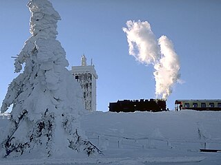
The Brocken Railway is one of three tourist metre gauge railways which together with the Harz Railway and Selke Valley Railway form the Harz Narrow Gauge Railways railway network in the Harz mountain range of Germany.
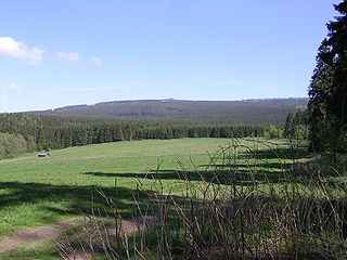
At 927 m above sea level (NN), the Bruchberg in the Upper Harz is the second highest mountain in Lower Saxony and the third highest in the Harz mountains in North Germany. It lies between Altenau and Torfhaus in the middle of the Harz National Park. The Bruchberg is more like a plateau and has no real summit. This plateau is partly covered with trees, but on the sunny southern slopes the trees have largely died as a result of bark beetle infestation. Following this insect destruction, a new natural forest, rich in its variety of species, is now growing in the heart of the Harz National Park.

The Königsberg is a neighbouring peak of the Brocken and, at 1033.5 m above sea level the third highest elevation in the Harz mountains. It lies on a long ridge that runs from southeast to northwest about 1.5 km south of the Brocken's summit. Near its summit on the northwest side is the rock formation of Hirschhörner. To the east the land descends to the Schwarze Schluftwasser, a small tributary of the Kalte Bode which flows south of the mountain. To the east on the far side of the Schwarzer Schluftwasser is the Heinrichshöhe, another subpeak of the Brocken.

The Hanskühnenburg is a mountain hut in the Harz mountains. It is located at a height of 811 m (2,661 ft) above sea level in fields known as Auf dem Acker, or simply Acker, in the middle of the Harz National Park and has its own observation tower. Its name comes from the legendary Hanskühnenburg Crag 300 metres to the northwest, which was visited on 14 August 1784 by Johann Wolfgang von Goethe. Opposite the tower are the Hanskühnenburg Rocks that are relatively small by comparison with the Klippe. A bronze plaque was mounted on these rocks in 1999 to commemorate Goethe's visit. In front of the Hanskühnenburg Rocks, a monument was erected in 1924 to Albert Leo Schlageter. It has since fallen over and is rather weathered.
Torfhaus is a village in the borough of the mining town of Altenau in the Harz mountains of Germany and lies at a height of about 800 m above sea level (NN). It is the highest settlement in Lower Saxony.

The Harz Witches' Trail is a footpath, just under 100 km long, in Germany that runs from Osterode through the Harz mountains and over its highest peak, the Brocken, to Thale. It is a project by the Harz Transport Association and Harz Club and is part of the system of trails known as the Harzer Wandernadel.

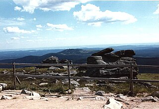
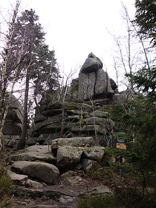
The Kahle Klippe is a rock formation in the High Harz in central Germany on the eastern slope of the Brocken above the valley of the Ecker.
The Hirschhorn Rocks are a natural monument in the Harz National Park in central Germany.

The Kaiser Way, literally "Emperor Way", is a thematic long distance footpath in the Harz mountains of Germany, which is about 110 km long and crosses both the Harz and the Kyffhäuser hills. From Goslar and Bad Harzburg on the northern edge of the Harz it runs across the Harz to Walkenried in the south; and then via Nordhausen to Tilleda on the Kyffhäuser.

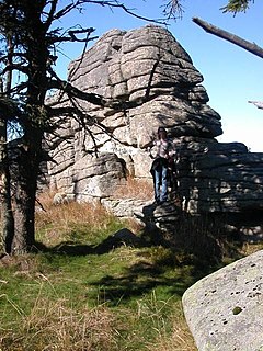
Schnarcherklippen is the name of a rock formation south of the village of Schierke in the High Harz mountains of Saxony-Anhalt in central Germany. The name translates roughly to "snoring crags" or "snoring rocks".

Goetheweg station is located between the stations of Schierke and Brocken on the Brocken Railway in the Harz Mountains of Central Germany at a height of 956 m above sea level. The track layout today consists, as in the past, of a horizontal reversing track (Rückdrückgleis) and just one turnout, whilst the running line maintains its continuous gradient of 33 permille.
The Eckerloch is a forested mountain valley, 845 metres above sea level near the village of Schierke in the Harz Mountains of central Germany.

The Scharfenstein is a mountain, 697.6 m above sea level (NN) high, in the Harz Mountains of Germany, near Ilsenburg in the district of Harz in Saxony-Anhalt. It is part of the Harz National Park.
The Ahrensklint or Ahrentsklint in the Harz Mountains is a granite rock formation, 822.4 m above sea level (NN), on the Erdbeerkopf in Harz district in the German state of Saxony-Anhalt.


