Benneckenstein is a town in the district of Harz, in Saxony-Anhalt, Germany. Since 1 January 2010, it has been part of the town of Oberharz am Brocken. Benneckenstein is in the eastern Harz, 14 km southeast of Braunlage, and 24 km south of Wernigerode.

The Wolfsklippen, also called the Wolfsklippe, is a granite mountain in the Harz mountains in Central Germany with an observation platform on the summit. Its height is frequently given as about 723 m above sea level (NN), but occasionally also as only around 710 m above NN.

The Hohnekamm or Hohne Kamm is a mountain ridge up to 900 m above sea level high in the Harz mountains of central Germany. It is located in the state of Saxony-Anhalt, and is well known for its rock towers or tors, the Hohneklippen.
The Taubenklippe is a rock formation in the Harz mountains in the German state of Saxony-Anhalt. It lies about halfway between Bad Harzburg and Ilsenburg at a height of 572 m above NN on the eastern slopes of the Ecker valley. From the crag there is a good view over Harz Foreland, the heights near Bad Harzburg and the highest mountain in the Har, the Brocken. The Taubenklippe may be reached from the Ecker valley on a footpath, some 6 km long, that starts in Ilsenburg.
The Ottofels, named after Prince Otto of Stolberg-Wernigerode, is a tor and natural monument near Wernigerode in the Harz mountains of central Germany.

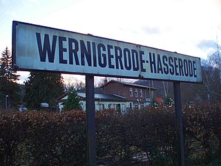
The Renneckenberg is a mountain, roughly 933 metres (3,061 ft) high, in the High Harz part of the Harz mountain range of central Germany within the borough of Wernigerode in the state of Saxony-Anhalt.
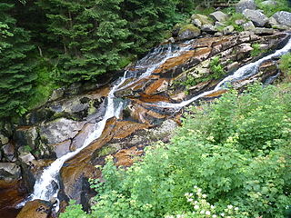
The Steinerne Renne is a waterfall and natural monument near the town of Wernigerode in the Harz mountains of central Germany.

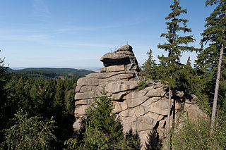
The Trudenstein is a rock formation and popular hiker's destination in the Harz Mountains of central Germany. It is located in the federal state of Saxony-Anhalt.
The Bielstein Tunnel is a disused railway tunnel in Saxony-Anhalt in the Harz Mountains of Central Germany. The tunnel is 465.7 metres long and lies between the zig zag of Michaelstein and Braunesumpf. It belonged to the Erzstufen Railway and, from 1885, to the Harz Railway . During the construction of the Harz Railway the tunnel profile was widened and Braunesumpf station laid out. When the Rübeland Railway was electrified from 1960 to 1965 the tunnel profile had to be widened again. In addition the tunnel was found to be in poor condition so that it was abandoned and the line was relaid further east through a cutting. The tunnel is no longer accessible today.

The Bremen Hut in the Harz Mountains is a refuge hut and shelter in that part of the Harz National Park lying within the borough of Ilsenburg (Harz) in Harz district in the German state of Saxony-Anhalt.
The Ahrensklint or Ahrentsklint in the Harz Mountains is a granite rock formation, 822.4 m above sea level (NN), on the Erdbeerkopf in Harz district in the German state of Saxony-Anhalt.

The Barenberg, also called the Bärenberg or Bärenkopf, is a mountain, 695.5 m above sea level (NN), in the Harz Mountains of Germany near the village of Schierke, Harz county, in the state of Saxony-Anhalt.

The Röhrigschacht is an old copper slate mine which, today, is a mining museum and show mine in the village of Wettelrode in the county of Mansfeld-Südharz in the German state of Saxony-Anhalt.

The Kapitelsberg in the Harz Mountains of Germany is a hill, 535.7 m above sea level (NN), near the village of Tanne in the county of Harz, Saxony-Anhalt.
The Wilhelmsblick in the Harz Mountains of central Germany is a viewing point near the village of Treseburg in the Bode Gorge in the county of Harz, Saxony-Anhalt. From this single point, four different stretches of the River Bode may be seen as it swings in great loops around the spur on which the viewing point is located.
The Drei-Länder-Stein is a boundary stone at the tripoint of the German federal states of Lower Saxony, Saxony-Anhalt and Thuringia near the Großer Ehrenberg mountain in the Harz.

The Hunrodeiche or, more rarely, the Hunrodseiche, in the Harz Mountains of central Germany is an oak tree over 1,000 years old near Hainfeld in the county of Mansfeld-Südharz in the state of Saxony-Anhalt.

The Dehnenkopf in the Harz Mountains of central Germany is a summit about 775 m above sea level (NN) near Torfhaus in the unincorporated area of Harz in the county of Goslar in Lower Saxony.

The Stierbergsteich in the Harz Mountains of central Germany is a storage pond near Rothesütte on the boundary of the counties of Harz (Saxony-Anhalt) and Nordhausen (Thuringia).
The Scharfenstein is a 462.4 m above sea level (NN) high hill spur of the Eichberg-Süd in the Harz Mountains of Germany, near the town of Wernigerode in the county of Harz in Saxony-Anhalt.