Scharzfeld

Last updated
View of Scharzfeld from Ritterstein ScharzfeldRitterstein.jpg
View of Scharzfeld from Ritterstein

Scharzfeld is a village in the borough of Herzberg am Harz in the district of Göttingen in South Lower Saxony, Germany.

Herzberg am Harz Place in Lower Saxony, Germany

Herzberg am Harz is a town in the Göttingen district of Lower Saxony, Germany.

South Lower Saxony

South Lower Saxony refers to the southern part of the German federal state of Lower Saxony. The region so described is neither historically nor geographically clearly defined to the north within Lower Saxony. It cuts across the more obviously delineated natural regions of the Weser Uplands, Leine valley, Leine Uplands and the western parts of the Harz mountains as well as the western part the historical region of Eichsfeld.

Germany Federal parliamentary republic in central-western Europe

Germany, officially the Federal Republic of Germany, is a country in Central and Western Europe, lying between the Baltic and North Seas to the north, and the Alps to the south. It borders Denmark to the north, Poland and the Czech Republic to the east, Austria and Switzerland to the south, France to the southwest, and Luxembourg, Belgium and the Netherlands to the west.

Contents

Scharzfeld lies at a height of about 220 m above sea level and has 1,765 inhabitants (as at 1 October 2006).

Normalnull

Normalnull or Normal-Null is an outdated official vertical datum used in Germany. Elevations using this reference system were to be marked "Meter über Normal-Null". Normalnull has been replaced by Normalhöhennull.

The first recorded mention of Scharzfeld is in a deed that relates to the year 952 and was probably forged in the 13th century. This stated that Otto the Great confirmed Schartfelde and other villages as belonging to the monastery at Pöhlde. [1] [2]

Otto I, Holy Roman Emperor German king and first emperor of the Ottonian empire

Otto I, traditionally known as Otto the Great, was German king from 936 and Holy Roman Emperor from 962 until his death in 973. He was the oldest son of Henry I the Fowler and Matilda.

Pöhlde is a village in southern Lower Saxony in Germany. It is part of the town Herzberg am Harz. It has a population of 2207. Archaeological excavation has revealed traces of settlement dating to the 2nd through 4th centuries AD. The town is noted for its Benedictine abbey. The Annals of Pöhlde, an important 12th century historical text, were composed here.

Culture and places of interest

Unicorn Cave geographical object

The Unicorn Cave is the largest show cave in the West Harz, about 1½ kilometres northwest of Scharzfeld in the borough of Herzberg am Harz in central Germany. It is a karst cave set in Zechstein dolomite rock.

Scharzfels Castle rock castle

Scharzfels Castle is the medieval ruin of a fortification located east of the village of Scharzfeld in the borough of Herzberg am Harz in central Germany. It lies in a wood on a ridge about 150 m above the Oder valley. For centuries after its construction in the 10th or 11th century it remained an impregnable fortress. The inner ward is built on a dolomite rock outcrop about 20 m high. The castle was first captured after a siege in 1761 during the Seven Years' War and then blown up.

Großer Knollen mountain in the Harz, Germany

The Großer Knollen is a 687.4-metre-high (2,255 ft) mountain in the southwestern part of the Harz in Lower Saxony, Germany.

Related Research Articles

Hermann, Freiherr von Soden German Biblical scholar

Baron Hermann von Soden was a German Biblical scholar, minister, professor of divinity, and textual theorist.

Pankow (German band) German rock band

Pankow are a German rock band, founded in East Berlin in 1981. Their name came from the Berlin district of Pankow, which was once home to most of the officials of the East German government. The band's original lineup consisted of Jürgen Ehle, André Herzberg, Rainer Kirchmann, Jäcki Reznicek and Frank Hille. Other members were Stefan Dohanetz, Ingo York and Jens Jensen.

Bovenden Place in Lower Saxony, Germany

Bovenden is a municipality in the district of Göttingen, in Lower Saxony, Germany. In 2010 the population in the eight villages belonging to the municipality was 13,350.

Dębczyn culture archaeological culture

The Dębczyn group is an archeological culture in Pomerania from the 3rd to 6th centuries. It was derived from the neighboring Wielbark culture with influences from the Elbe region, and succeeded by migration of West Slavs, the Pomeranian tribes.

The South Harz Railway is a railway line through the German states of Lower Saxony and Thuringia. It runs from Northeim to Nordhausen, via Herzberg am Harz, Bad Lauterberg-Barbis, Bad Sachsa, Walkenried and Ellrich. The line is 69 kilometres (43 mi) long.

Ischenrode is a village in the Gemeinde Gleichen, Göttingen, Braunschweig Bezirk (district), Lower Saxony, Germany.

Early history of Pomerania

After the glaciers of the Ice Age in the Early Stone Age withdrew from the area, which since about 1000 AD is called Pomerania, in what are now northern Germany and Poland, they left a tundra. First humans appeared, hunting reindeer in the summer. A climate change in 8000 BC allowed hunters and foragers of the Ertebølle-Ellerbek culture to continuously inhabit the area. These people became influenced by farmers of the Linear Pottery culture who settled in southern Pomerania. The hunters of the Ertebølle-Ellerbek culture became farmers of the Funnelbeaker culture in 3000 BC. The Havelland culture dominated in the Uckermark from 2500 to 2000 BC. In 2400 BC, the Corded Ware culture reached Pomerania and introduced the domestic horse. Both Linear Pottery and Corded Ware culture have been associated with Indo-Europeans. Except for Western Pomerania, the Funnelbeaker culture was replaced by the Globular Amphora culture a thousand years later.

SM UB-35 was a German Type UB II submarine or U-boat in the German Imperial Navy during World War I. The U-boat was ordered on 22 July 1915 and launched on 28 December 1915. She was commissioned into the German Imperial Navy on 22 June 1916 as SM UB-35.

The Gustow group is an archaeological culture of the Roman Iron Age in Western Pomerania. The Gustow group is associated with the Germanic tribe of the Rugii.

Medingen Abbey Church in Lower Saxony, Germany

Medingen Abbey or Medingen Convent is a former Cistercian nunnery. Today it is a residence for women of the Protestant Lutheran faith near the Lower Saxon town of Bad Bevensen and is managed by the Monastic Chamber of Hanover. The current director of the abbey (Äbtissin) is the art historian Dr Kristin Püttmann.

Sieber (river) river in the Harz Mountains, Germany

The Sieber is a 35-kilometre-long, right hand tributary of the Oder in the Harz mountains of Germany.

Herzberg Castle château

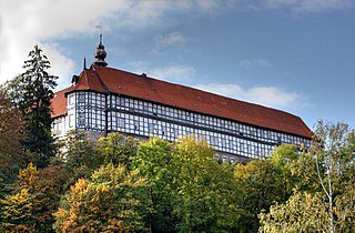
Herzberg Castle is a German schloss in Herzberg am Harz in the district of Göttingen in the state of Lower Saxony. The present-day, quadrangular building has its origins in the 11th century as a medieval castle. After a fire in 1510 it was rebuilt as a schloss and is one of the few in Lower Saxony that was constructed as a timber-framed building. Because it belonged to the House of Welf for 700 years it is also known as the Welf Castle of Herzberg.

Erbsen Ortschaft of Adelebsen in Lower Saxony, Germany

Erbsen is a village in the Flecken Adelebsen in the Landkreis Göttingen in Lower Saxony, Germany. The village has about four hundred inhabitants. It lies some twelve kilometers west of Göttingen on the main road to Adelebsen proper.

SM <i>UB-57</i>

SM UB-57 was a German Type UB III submarine or U-boat in the German Imperial Navy during World War I. She was commissioned into the Flanders Flotilla of the German Imperial Navy on 30 July 1917 as SM UB-57.

Franz Friedrich Roger Wilmans was a German historian and archivist.

Elbe-Elster Land

Elbe-Elster Land, also called the Elbe-Elster region (Elbe-Elster-Gebiet) is a region around the tripoint of the German states of Brandenburg, Saxony-Anhalt and Saxony. It is part of the North German Plain and is named after the two major rivers that have their confluence here: the Elbe and the Black Elster.

References

  1. Uwe Ohainski; Jürgen Udolph (2000), Jürgen Udolph, ed., "Die Ortsnamen des Landkreises Osterode", Niedersächsisches Ortsnamensbuch (NOB) (in German), Bielefeld: Verlag für Regionalgeschichte, Teil II, pp. 146ff, ISBN   3-89534-370-6
  2. Die Urkunden Konrad I. Heinrich I. und Otto I.. In: Monumenta Germaniae Historica, Die Urkunden der deutschen Könige und Kaiser, Band 1. Hannover 1879-1894. Nr. 439, S. 593f. In der Einleitung der Urkunde (S. 593 (gif)) wird die Fälschung diskutiert.

Coordinates: 51°37′48″N10°22′56″E / 51.63000°N 10.38222°E / 51.63000; 10.38222

Geographic coordinate system Coordinate system

A geographic coordinate system is a coordinate system that enables every location on Earth to be specified by a set of numbers, letters or symbols. The coordinates are often chosen such that one of the numbers represents a vertical position and two or three of the numbers represent a horizontal position; alternatively, a geographic position may be expressed in a combined three-dimensional Cartesian vector. A common choice of coordinates is latitude, longitude and elevation. To specify a location on a plane requires a map projection.