
Volkmarskeller is the name of a cave that used to have a church next to it in the vicinity of Blankenburg (Harz) in the German state of Saxony-Anhalt.
Volkmarskeller is the name of a cave that used to have a church next to it in the vicinity of Blankenburg (Harz) in the German state of Saxony-Anhalt.
Around the period from 850 to 870, the hermit Liutbirg, who was highly respected by her contemporaries, lived in a retreat. She was a close confidante of bishops Haimo of Halberstadt and Ansgar of Bremen. Until the 1930s, her retreat was believed to have been at Volkmarskeller, until Walther Grosse was able to show that it could have been at Wendhusen Abbey near Thale.
Either way, the church near the cave of Volkmarskeller was dedicated to St. Michael and was gifted in 956 by Otto I to Quedlinburg Abbey. From then on, the cave, which was not far from the imperial hunting lodge of Bodfeld, provided shelter for pious settlers. For example, the death of a certain Bernhardus presbyter solitarius de Laide sancti Michaelis was recorded in 1118. According to the Annales Cistercienses, after several years of preparation that had begun in 1135, the cave and church was officially opened on 28 July 1146 as accommodation for Cistercian monks from Kamp Abbey under Abbot Roger.
In 1146, at the request of the Abbess of Quedlinburg, Beatrix II, Pope Innocent II approved the founding of the abbey and the allocation to the monastery of estates in Marsleben, Groß- and Klein-Ditfurt, Sülten and other places (today mostly abandoned villages near Quedlinburg). These had already been donated to the Quedlinburg Abbey in 1138/39 by Quedlinburg ministerialis, Burchard. In the period from 1151 to 1167, the monastery was moved to Evergodesrode at the lower end of the valley at the present site of Michaelstein Abbey.
The ruined cave dwellings were excavated in 1884-1887 by architect (Baurat) Brinkmann and made accessible.
The Volkmarskeller can be visited free of charge. It is located in the upper part of the monastery grounds, just above the trail that leads from Michaelstein Abbey to the hamlet of Eggeröder Brunnen. At the Volkmarskeller is a checkpoint (no. 87) in the Harzer Wandernadel hiking network. The nearest car park is in Eggeröder Brunnen which is about 15 minutes walk away. [1]
Not far away is the former iron ore pit of Volkmar. In 1893, there was an explosion here that was caused by the complications of handling dynamite at temperatures below 7 °C. The Hüttenrode Alpine Club erected a memorial in 2007 to the miners who were killed. This is on the track and trail between Eggeröder Brunnen-Volkmarskeller and Michaelstein Abbey at Blankenburg.

Blankenburg (Harz) is a town and health resort in the district of Harz in Saxony-Anhalt, Germany, at the north foot of the Harz Mountains, 12 miles (19 km) southwest of Halberstadt.

Quedlinburg Abbey was a house of secular canonesses (Frauenstift) in Quedlinburg in what is now Saxony-Anhalt, Germany. It was founded in 936 on the initiative of Saint Mathilda, the widow of the East Frankish King Henry the Fowler, as his memorial. For many centuries it and its abbesses enjoyed great prestige and influence. Quedlinburg Abbey was an Imperial Estate and one of the approximately forty self-ruling Imperial Abbeys of the Holy Roman Empire. It was disestablished in 1802/3. The church, known as Stiftskirche St Servatius, is now used by the Lutheran Evangelical Church in Germany.
Michaelstein Abbey is a former Cistercian monastery, now the home of the Stiftung Kloster Michaelstein - Musikinstitut für Aufführungspraxis, near the town of Blankenburg in the Harz in Sachsen-Anhalt, Germany.
Countess Anna of Stolberg-Wernigerode was a German noblewoman who reigned as Princess-Abbess of Quedlinburg from 1516 until her death. She was elected princess-abbess under the name Anna II at the age of twelve, succeeding Magdalena of Anhalt.

The Harzer Wandernadel is a system of hiking awards in the Harz mountains in central Germany. Hikers can earn awards at different levels of challenge by walking to the various checkpoints in the network and stamping their passbooks to record the visit. With 222 checkpoints in three federal states and across five districts in the Harz and with membership in five figures, the system has gained a following Germany-wide.
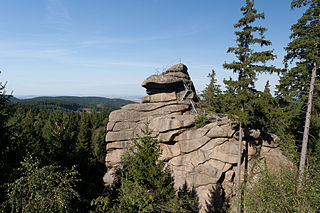
The Ottofels, named after Prince Otto of Stolberg-Wernigerode, is a tor and natural monument near Wernigerode in the Harz mountains of central Germany.

The Unicorn Cave is the largest show cave in the West Harz, about 1.5 kilometres (0.9 mi) northwest of Scharzfeld in the borough of Herzberg am Harz in central Germany. It is a karst cave developed in dolomite strata that is part of the Zechstein.

Regenstein Castle is a ruined castle that lies three kilometres north of Blankenburg in the German state of Saxony-Anhalt. It is a popular tourist destination where, each year, a knight's tournament and a garrison festival are held.
The Luisenburg was a small palace that existed from 1728 to 1945 near Blankenburg (Harz) in central Germany.
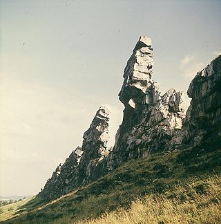
The Teufelsmauer is a rock formation made of hard sandstones of the Upper Cretaceous in the northern part of the Harz Foreland in central Germany. This wall of rock runs from Blankenburg (Harz) via Weddersleben and Rieder to Ballenstedt. The most prominent individual rocks of the Teufelsmauer have their own names. The Teufelsmauer near Weddersleben is also called the Adlersklippen.

The Konradsburg is a former castle, monastery and manor house near Ermsleben in the German federal state of Saxony-Anhalt.

The Bielstein Tunnel is a disused railway tunnel in Saxony-Anhalt in the Harz Mountains of Central Germany. The tunnel is 465.7 metres long and lies between the zig zag of Michaelstein and Braunesumpf. It belonged to the Erzstufen Railway and, from 1885, to the Harz Railway.

The Galgenberg is a 506.1-metre-high hill east of Elbingerode (Harz) in the Harz Mountains of central Germany. It marks the highest point on the row of limestone crags found there. The old Trock Way (Trockweg), which ran from Quedlinburg to the imperial stronghold of Bodfeld, probably ran past the Galgenberg immediately to the north. East of the hill lies the abandoned village of Erdfelde that was closely linked to Bodfeld.

The Sandhöhlen are a natural monument in the German state of Saxony-Anhalt. They are two sand caves known individually as the Große Sandhöhle and Kleine Sandhöhle. The caves are located in a wooded area called im Heers below the fortress and crags of Regenstein north of the town of Blankenburg (Harz). It is surmised that a Germanic thingstead was held here in protohistoric times. On the Große Sandhöhle is a checkpoint in the Harzer Wandernadel hiking network which was voted by hikers as the most beautiful checkpoint of the year in 2009.

The Bremen Hut in the Harz Mountains is a refuge hut and shelter in that part of the Harz National Park lying within the borough of Ilsenburg (Harz) in Harz district in the German state of Saxony-Anhalt.

The Ackeburg, also called the Ackenburg, in the Harz Mountains of central Germany, is the site of a high medieval hill castle, 333.2 m above sea level (NN), in the borough of Falkenstein/Harz in Harz district in the state of Saxony-Anhalt. It was first mentioned in 1216 and was abandoned or destroyed in 1400. There was also a village associated with it, known as Akkeburg.
The Kapitelsberg in the Harz Mountains of Germany is a hill, 535.7 m above sea level (NN), near the village of Tanne in the county of Harz, Saxony-Anhalt.
The Ölbergshöhe in the Harz Mountains of central Germany is a mountain spur, 320.6 metres (1,052 ft) above sea level, of the Ramberg ridge near Bad Suderode in the Saxony-Anhalt county of Harz.
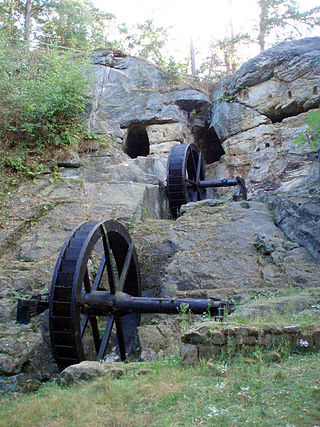
The Regenstein Mill was a water-powered corn and oil mill below Regenstein Castle north of the town of Blankenburg (Harz) in the county of Harz (Saxony-Anhalt).
51°47′45″N10°53′08″E / 51.79589°N 10.885552°E
| International | |
|---|---|
| National | |