
The Harz is a highland area in northern Germany. It has the highest elevations for that region, and its rugged terrain extends across parts of Lower Saxony, Saxony-Anhalt, and Thuringia. The name Harz derives from the Middle High German word Hardt or Hart. The name Hercynia derives from a Celtic name and could refer to other mountain forests, but has also been applied to the geology of the Harz. The Brocken is the highest summit in the Harz with an elevation of 1,141.1 metres (3,744 ft) above sea level. The Wurmberg is the highest peak located entirely within the state of Lower Saxony.

The Rammelsberg is a mountain, 635 metres (2,083 ft) high, on the northern edge of the Harz range, south of the historic town of Goslar in the North German state of Lower Saxony. The mountain is the location of an important silver, copper, and lead mine. When it closed in 1988, it had been the only mine still working continuously for over 1,000 years. Because of its long history of mining and testimony to the advancement and exchange of technology over many centuries, the visitor mine of Rammelsberg was inscribed as a UNESCO World Heritage Site in 1992.
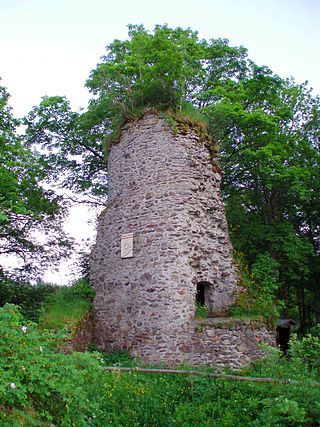
The Königsburg is a ruined medieval castle southeast of Königshütte, a village in the borough of Oberharz am Brocken, in Harz district in the German state of Saxony-Anhalt.

Ilsenburg is a town in the district of Harz, in Saxony-Anhalt in Germany. It is situated under the north foot of the Harz Mountains, at the entrance to the Ilse valley with its little river, the Ilse, a tributary of the Oker, about six 6 miles (9.7 km) north-west of the town of Wernigerode. It received town privileges in 1959. Owing to its surrounding of forests and mountains as well as its position on the edge of the Harz National Park, Ilsenburg is a popular tourist resort. Since 2002, it is officially an air spa.

Sankt Andreasberg is a former town in the district of Goslar, in Lower Saxony, Germany. Since 1 November 2011, it is part of the town Braunlage. It is situated in the Harz, approximately 7 km west of Braunlage proper, and 20 km east of Osterode am Harz.

Altenau is a town and a former municipality in the district of Goslar, in Lower Saxony, Germany. Since 1 January 2015 it is part of the town Clausthal-Zellerfeld.

Altenbrak is a village and a former municipality in the district of Harz, in Saxony-Anhalt, Germany.

The Harzer Wandernadel is a system of hiking awards in the Harz mountains in central Germany. Hikers can earn awards at different levels of challenge by walking to the various checkpoints in the network and stamping their passbooks to record the visit. With 222 checkpoints in three federal states and across five districts in the Harz and with membership in five figures, the system has gained a following Germany-wide.
The Langelsheim–Altenau (Oberharz) railway was a railway line, that ran through the Upper Harz in Central Germany. It was also called the Upper Harz Railway or Harz Railway. It was built in order to enable the Magdeburg-Halberstadt Railway Company to access the mines in the Harz mountains.

The Hanskühnenburg is a mountain hut in the Harz mountains. It is located at a height of 811 m (2,661 ft) above sea level in fields known as Auf dem Acker, or simply Acker, in the middle of the Harz National Park and has its own observation tower. Its name comes from the legendary Hanskühnenburg Crag 300 metres to the northwest, which was visited on 14 August 1784 by Johann Wolfgang von Goethe. Opposite the tower are the Hanskühnenburg Rocks that are relatively small by comparison with the Klippe. A bronze plaque was mounted on these rocks in 1999 to commemorate Goethe's visit. In front of the Hanskühnenburg Rocks, a monument was erected in 1924 to Albert Leo Schlageter. It has since fallen over and is rather weathered.

Auf dem Acker is a mountain ridge up to 865.1 m (2,838 ft) high, which is located in the southwestern part of the Harz mountains in Lower Saxony (Germany).

The small village of Buntenbock lies on the plateau of the Harz mountains in Germany and is part of the mining and university town of Clausthal-Zellerfeld. It is a state-recognised climatic health resort and has accommodation for 200 visitors as well as 700 inhabitants.

The Harz Witches' Trail is a footpath, just under 100 km long, in Germany that runs from Osterode through the Harz mountains and over its highest peak, the Brocken, to Thale. It is a project by the Harz Transport Association and Harz Club and is part of the system of trails known as the Harzer Wandernadel.

Romkerhall is a popular tourist destination on the River Oker in the Harz Mountains of Germany. There is a public car park here as well as a hotel and restaurant opposite the Romkerhall Waterfall. Romkerhall lies within the unincorporated area of Harz in the Lower Saxon county of Goslar in the Harz Mountains. The hotel and waterfall form a small tourist attraction which is marketed as the "Kingdom of Romkerhall - the smallest kingdom in the world!"
The Molkenhaus is a historic house near Wernigerode, Harz, Germany, located on the Jägerkopf hill above the Steinerne Renne waterfall and the source region of the Holtemme river. The timber-framed building, which was built by order of the Senior Master Hunter (Oberjägermeister) of the counts of Stolberg, von Meseberg, at the beginning of the 18th century, belonged to the Ilsenburger Marienhof and was used for hunting purposes and the production of butter. Nowadays it is used by the Harz National Park.

The Dreieckige Pfahl is a historic boundary stone, about 1.35 metres high and made of granite, located southwest of the Brocken, the highest mountain in the Harz Mountains of central Germany. The stone, erected before 1866, marked the border between the Kingdom of Hanover and the Duchy of Brunswick. Originally this spot was a tripoint. During the division of Germany the border between the German Democratic Republic and the Federal Republic of Germany ran past the Dreieckiger Pfahl. Today it marks the border between the states of Saxony-Anhalt and Lower Saxony, the post lying just within the Lower Saxon side. During the Cold War it was accessible from the west.
The Drei-Länder-Stein is a boundary stone at the tripoint of the German federal states of Lower Saxony, Saxony-Anhalt and Thuringia near the Großer Ehrenberg mountain in the Harz.
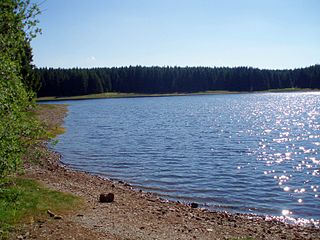
The Jägersbleeker Teich in the Harz Mountains of central Germany is a storage pond near the town of Clausthal-Zellerfeld in the county of Goslar in Lower Saxony. It is one of the Upper Harz Ponds that were created for the mining industry.
The Dehnenkopf in the Harz Mountains of central Germany is a summit about 775 m above sea level (NN) near Torfhaus in the unincorporated area of Harz in the county of Goslar in Lower Saxony.
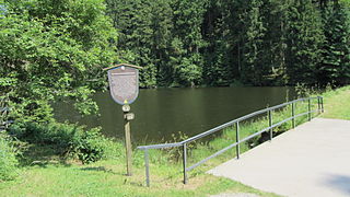
The Lower Grumbach Pond, usually just Grumbach Pond, is an old mining reservoir or Kunstteich between Hahnenklee and Wildemann in the Upper Harz mountains in Germany

