
Lower Saxony is a German state (Land) situated in northwestern Germany. It is the second-largest state by land area, being larger than Denmark with 47,624 km2 (18,388 sq mi), and fourth-largest in population among the 16 Länder federated as the Federal Republic of Germany. In rural areas, Northern Low Saxon and Saterland Frisian are still spoken, but the number of speakers is declining.

Salzgitter is an independent city in southeast Lower Saxony, Germany, located between Hildesheim and Braunschweig. Together with Wolfsburg and Braunschweig, Salzgitter is one of the seven Oberzentren of Lower Saxony. With 101,079 inhabitants and 223.92 square kilometres (86.46 sq mi), its area is the largest in Lower Saxony and one of the largest in Germany. Salzgitter originated as a conglomeration of several small towns and villages, and is today made up of 31 boroughs, which are relatively compact conurbations with wide stretches of open country between them. The main shopping street of the young city is in the borough of Lebenstedt, and the central business district is in the borough of Salzgitter-Bad. The city is connected to the Mittellandkanal and the Elbe Lateral Canal by a distributary. The nearest metropolises are Braunschweig, about 23 kilometres to the northeast, and Hanover, about 51 km to the northwest. The population of the City of Salzgitter has exceeded 100,000 inhabitants since its foundation in 1942, when it was still called Watenstedt-Salzgitter. Beside Wolfsburg, Leverkusen and Eisenhüttenstadt, Salzgitter is therefore one of the few cities in Germany founded during the 20th century.

Goslar is a historic town in Lower Saxony, Germany. It is the administrative centre of the district of Goslar and located on the northwestern slopes of the Harz mountain range. The Old Town of Goslar and the Mines of Rammelsberg are UNESCO World Heritage Sites. Each year Goslar awards the Kaiserring to an international artist, called the "Nobel Prize" of the art world.

The Principality of Calenberg was a dynastic division of the Welf duchy of Brunswick-Lüneburg established in 1432. Calenberg was ruled by the House of Hanover from 1635 onwards; the princes received the ninth electoral dignity of the Holy Roman Empire in 1692. Their territory became the nucleus of the Electorate of Hanover, ruled in personal union with the Kingdom of Great Britain from 1714 onwards. The principality received its name from Calenberg Castle, a residence of the Brunswick dukes.
Lutter or Lütter may refer to:

Bad Harzburg is a spa town in central Germany, in the Goslar district of Lower Saxony. It lies on the northern edge of the Harz mountains and is a recognised saltwater spa and climatic health resort.

The Harzburg, also called Große Harzburg, is a former imperial castle, situated on the northwestern edge of the Harz mountain range overlooking the spa resort of Bad Harzburg in Goslar District in the state of Lower Saxony, Germany. It was erected from 1065 to 1068 at the behest of King Henry IV of Germany, slighted during the Saxon Rebellion in 1073-75, and a century later rebuilt under Emperor Frederick Barbarossa and his Welf successor Otto IV, who died here in 1218.

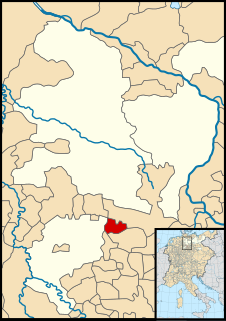
Ringelheim with 1,964 inhabitants is the sixth biggest quarter of Salzgitter in Lower Saxony, Germany, located on the Innerste River at the very far south-western end of the urban area. The Salzgitter-Ringelheim train station is the most important station of the city, as the Brunswick Southern Railway and the line from Hildesheim to Goslar cross here.

Herzberg am Harz is a town in the Göttingen district of Lower Saxony, Germany.
Vienenburg is a borough of Goslar, capital of the Goslar district, in Lower Saxony, Germany. The former independent municipality was incorporated in Goslar on 1 January 2014.
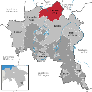
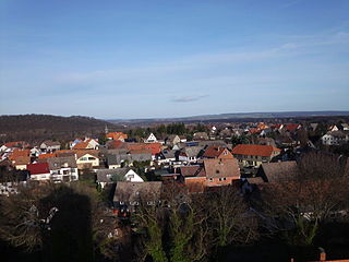
Liebenburg is a municipality in the district of Goslar, in Lower Saxony, Germany.
Goslar is a world heritage site in Germany.
Hahausen is a municipality in the district of Goslar in Lower Saxony, Germany.

Wulften am Harz is a municipality in Lower Saxony, Germany, near the towns of Northeim and Osterode am Harz.

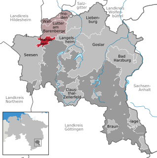
Lutter am Barenberge is a Samtgemeinde in the district of Goslar, in Lower Saxony, Germany. It is situated northwest of the Harz, approx. 13 km northwest of Goslar. Its seat is in the town Lutter am Barenberge.
Werlaburgdorf is a village and a former municipality in the district of Wolfenbüttel, Lower Saxony, Germany. Since 1 November 2013, it is part of the municipality Schladen-Werla.
The County of Blankenburg was a state of the Holy Roman Empire. Its capital was Blankenburg, it was located in and near the Harz mountains.
The County of Wernigerode was a state of the Holy Roman Empire which arose in the Harzgau region of the former Duchy of Saxony, at the northern foot of the Harz mountain range. The comital residence was at Wernigerode, now part of Saxony-Anhalt, Germany. The county was ruled by a branch of the House of Stolberg from 1429 until its mediatization to the Kingdom of Prussia in 1806. Nevertheless, the county remained in existence - with one short interruption - until the dissolution of the Kingdom of Prussia in 1918.


