
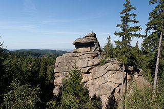
The Schalke is a mountain, 762 m above sea level (NN), in the Upper Harz in the German state of Lower Saxony. It lies in Goslar district north of Clausthal-Zellerfeld and west of Schulenberg.

The Harzer Wandernadel is a system of hiking awards in the Harz mountains in central Germany. The hiker can earn awards at different levels of challenge by walking to the various checkpoints in the network and stamping his or her passbook to record the visit. With 222 checkpoints in three federal states and across five districts in the Harz and with membership in five figures, the system has gained a following Germany-wide.
The Ottofels, named after Prince Otto of Stolberg-Wernigerode, is a tor and natural monument near Wernigerode in the Harz mountains of central Germany.

Drei Annen Hohne is the name of a small settlement within the municipal area of Wernigerode in Saxony-Anhalt, Germany.

The Treppenstein is a rock formation in the Oker valley in the Harz mountains of central Germany. It lies on the trail from the Romkerhall Waterfall to the Kästeklippen. The rocks consist of granite and have clearly undergone so-called "wool sack weathering" (Wollsackverwitterung).
The Luisenburg was a small palace that existed from 1728 to 1945 near Blankenburg (Harz) in central Germany.
The Molkenhaus is a historic house near Wernigerode, Harz, Germany, located on the Jägerkopf hill above the Steinerne Renne waterfall and the source region of the Holtemme river. The timber-framed building, which was built by order of the Senior Master Hunter (Oberjägermeister) of the counts of Stolberg, von Meseberg, at the beginning of the 18th century, belonged to the Ilsenburger Marienhof and was used for hunting purposes and the production of butter. Nowadays it is used by the Harz National Park.
The Bielstein Tunnel is a disused railway tunnel in Saxony-Anhalt in the Harz Mountains of Central Germany. The tunnel is 465.7 metres long and lies between the zig zag of Michaelstein and Braunesumpf. It belonged to the Erzstufen Railway and, from 1885, to the Harz Railway . During the construction of the Harz Railway the tunnel profile was widened and Braunesumpf station laid out. When the Rübeland Railway was electrified from 1960 to 1965 the tunnel profile had to be widened again. In addition the tunnel was found to be in poor condition so that it was abandoned and the line was relaid further east through a cutting. The tunnel is no longer accessible today.

The Galgenberg is a 506.1-metre-high hill east of Elbingerode (Harz) in the Harz Mountains of central Germany. It marks the highest point on the row of limestone crags found there. The old Trock Way (Trockweg), which ran from Quedlinburg to the imperial stronghold of Bodfeld, probably ran past the Galgenberg immediately to the north. East of the hill lies the abandoned village of Erdfelde that was closely linked to Bodfeld.

The Bremen Hut in the Harz Mountains is a refuge hut and shelter in that part of the Harz National Park lying within the borough of Ilsenburg (Harz) in Harz district in the German state of Saxony-Anhalt.

The Ilse valley is the ravine of the Ilse stream in the northern boundary of the Harz mountain range in Germany. Part of the Harz National Park, it runs from the town of Ilsenburg at the foot of the mountain range up to the source region near the summit of the Brocken massif, the highest mountain of the range. The scenic valley is a popular hiking area.
The Ahrensklint or Ahrentsklint in the Harz Mountains is a granite rock formation, 822.4 m above sea level (NN), on the Erdbeerkopf in Harz district in the German state of Saxony-Anhalt.

The Kapitelsberg in the Harz Mountains of Germany is a hill, 535.7 m above sea level (NN), near the village of Tanne in the county of Harz, Saxony-Anhalt.

The Helenenruh is a 629 metre high rocky ridge near the village of Elend in the Harz Mountains of central Germany.

The Hunrodeiche or, more rarely, the Hunrodseiche, in the Harz Mountains of central Germany is an oak tree over 1,000 years old near Hainfeld in the county of Mansfeld-Südharz in the state of Saxony-Anhalt.

The Heibeeksköpfe in the Harz Mountains of central Germany are a double summit with a maximum height of 465.2 m above sea level (NN), near Bad Lauterberg in the unincorporated area of Harz in the district of Göttingen in Lower Saxony.

A Köte is the term used in the Harz Mountains of central Germany for a charcoal burner's hut (Köhlerhütte). A Köte was occupied by a charcoal burner in order to look after a nearby wood pile (Kohlenmeiler). The charcoal burner prepared the necessary charcoal for the smelting of ores.
The Dehnenkopf in the Harz Mountains of central Germany is a summit about 775 m above sea level (NN) near Torfhaus in the unincorporated area of Harz in the county of Goslar in Lower Saxony.
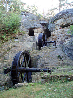
The Regenstein Mill was a water-powered corn and oil mill below Regenstein Castle north of the town of Blankenburg (Harz) in the county of Harz (Saxony-Anhalt).
The Jagdkopf a hill, 603.1 m above sea level (NN) high, in the Harz Mountains of Germany. It is located between the villages of Wieda and Zorge in the unincorporated area of Harz in the district of Göttingen in the state of Lower Saxony.
