
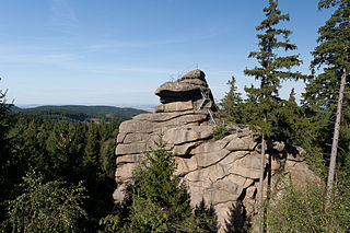
The Trudenstein is a rock formation and popular hiker's destination in the Harz Mountains of central Germany. It is located in the federal state of Saxony-Anhalt.
The Trudenstein is a rock formation and popular hiker's destination in the Harz Mountains of central Germany. It is located in the federal state of Saxony-Anhalt.
The Trudenstein lies beside the Glashütten Way [1] on the wooded southern slopes of the Hohnekopf ridge about two kilometres northeast of the village of Schierke in the Harz National Park. Two kilometres to the east, is the village of Drei Annen Hohne that, like Schierke, is part of the borough of Wernigerode. The Brocken Railway, an important heritage line, runs past the rocks immediately to the south, below a granite quarry. [2]
The rocks of the Trudenstein are composed of granite and their summit lies at an elevation of 671 m. [1]
The Trudenstein is a popular hiking destination that is easily reached from Drei Annen Hohne on marked trails. The summit of the rock formation has been made accessible to the general public using ladders. From the top there is a commanding view of large parts of the East and South Harz. In good weather, the nearby Wurmberg mountain, the villages of Schierke and Elend and the Stöberhai mountain, 15 kilometres away, may be seen. [1]
The Trudenstein is No. 17 in the system of checkpoints that form the Harzer Wandernadel hiking network. [3]
The name Trudenstein is derived from the appearance of the rocks which is supposed to resemble a drude, an old German, witch-like figure associated with dreams. [1] [4] In 1783 Johann Wolfgang von Goethe walked past the Trudenstein during one of his visits to the Harz and, in 1811, Caspar David Friedrich drew a sketch of the rocks. [5] They are also said to have inspired the group of rocks in the foreground of his painting, Der Watzmann. [6]
Ladders were first erected on the summit of the Trudenstein in 1894. [1]
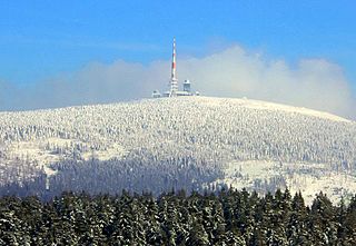
The Brocken, also sometimes referred to as the Blocksberg, is the highest peak of the Harz mountain range and also the highest peak of Northern Germany; it is located near Schierke in the German state of Saxony-Anhalt between the rivers Weser and Elbe. Although its elevation of 1,141 metres (3,743 ft) is below alpine dimensions, its microclimate resembles that of mountains of about 2,000 m (6,600 ft). The peak above the tree line tends to have a snow cover from September to May, and mists and fogs shroud it up to 300 days of the year. The mean annual temperature is only 2.9 °C (37.2 °F). It is the easternmost mountain in northern Germany; travelling east in a straight line, the next prominent elevation would be in the Ural Mountains in Russia.
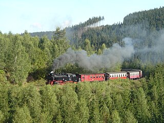
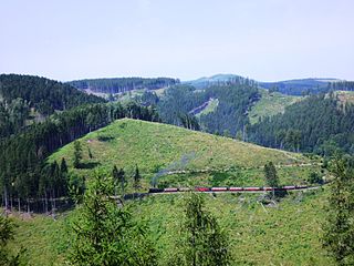
The Harz Narrow Gauge Railways is a railway company that operates a 1,000 mmmetre gauge network in the Harz mountains, in central Germany. The company was formed after the Second World War as a merger of two earlier companies. It owns about 140 kilometres of track, connecting the principal towns of Wernigerode, Nordhausen and Quedlinburg and several smaller settlements in the area. Much of the network is steeply graded and picturesque, but its most popular destination is the Brocken, the highest mountain in the region. The company runs a significant number of its trains with steam haulage, mostly employing 1950s vintage 2-10-2 tank locomotives, hauling traditional open-platform bogie carriages. The company is mainly owned by the various local authorities whose territories it serves.

Elbingerode (Harz) is an Ortsteil of Oberharz am Brocken in the Harz district, in the German state of Saxony-Anhalt. The former town was incorporated into the newly established municipality on 1 January 2010.

Schierke is a village and a former municipality in the Harz district, in the German state of Saxony-Anhalt. Since 1 July 2009, it is part of the town Wernigerode. Situated within the Harz mountain range in the valley of the river Bode, at the rim of the Harz National Park, it is mainly a tourist resort, especially for hiking and all kinds of winter sports.
The Harz Railway or Trans-Harz Railway was formerly the main line of the Harz Narrow Gauge Railways and runs north to south right across the Harz Mountains from Wernigerode to Nordhausen. However, the tourist attraction of the Brocken, the highest mountain in the Harz, is so great that the Brocken Railway is effectively the main line today. The Trans-Harz Railway joins up with the Selke Valley Railway to Quedlinburg at Eisfelder Talmühle where all trains are organised to make good connections.
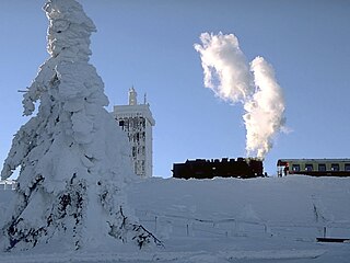
The Brocken Railway is one of three tourist metre gauge railways which together with the Harz Railway and Selke Valley Railway form the Harz Narrow Gauge Railways railway network in the Harz mountain range of Germany.

The Wolfsklippen, also called the Wolfsklippe, is a granite mountain in the Harz mountains in Central Germany with an observation platform on the summit. Its height is frequently given as about 723 m above sea level (NN), but occasionally also as only around 710 m above NN.

The Hohnekamm or Hohne Kamm is a mountain ridge up to 900 m above sea level high in the Harz mountains of central Germany. It is located in the state of Saxony-Anhalt, and is well known for its rock towers or tors, the Hohneklippen.
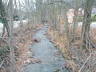
The Zillierbach is a stream in the Harz mountains of central Germany in the state of Saxony-Anhalt. It is about 13 kilometres (8 mi) long. The stream rises on the western side of the Hohneklippen crags and runs initially southwards, then swings northeast at Drei Annen Hohne. South of Drei Annen Hohne it picks up the waters of the Wormsgraben, its main tributary. The Zillierbach supplies the Zillierbach Dam near Elbingerode. In front of the settlement of Voigtstieg it is joined by another two smaller brooks. In the Middle Ages the Zillierbach powered the mills between Voigtstieg and Wernigerode. This section of the valley is still called Mühlental today. In its lower reaches before its mouth the stream is known as the Flutrenne. The stream discharges into the Holtemme at Wernigerode northwest of the West Gate (Westerntor). It drops through a vertical height of almost 400 metres (1,300 ft) from source to mouth.
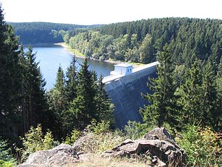
The Zillierbach Dam lies in the East Harz in the German state of Saxony-Anhalt near the town of Elbingerode (Harz) and impounds the Zillierbach stream. It supplies drinking water to several villages in the High Harz as well as the town of Wernigerode; it also provides flood protection.
The Ottofels, named after Prince Otto of Stolberg-Wernigerode, is a tor and natural monument near Wernigerode in the Harz mountains of central Germany.

Drei Annen Hohne is the name of a small settlement within the municipal area of Wernigerode in Saxony-Anhalt, Germany.
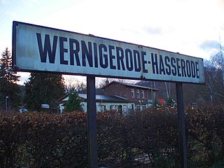
Hasserode has been a quarter in the town of Wernigerode since 1907, a town in the German state of Saxony-Anhalt.

Harz granite is found in the Harz Mountains of central Germany. It may be divided into five types, all of which were widely used as natural stone: Knaupsholz granite, Birkenkopf granite, Wurmberg granite, Königskopf granite and Ilsestein granite. The first three granites were widely used in North Germany, Belgium and the Netherlands and, later, also in East Germany. Knaupsholz granite was "for a long time one of the most important types of cut stone in the former GDR".
The Molkenhaus is a historic house near Wernigerode, Harz, Germany, located on the Jägerkopf hill above the Steinerne Renne waterfall and the source region of the Holtemme river. The timber-framed building, which was built by order of the Senior Master Hunter (Oberjägermeister) of the counts of Stolberg, von Meseberg, at the beginning of the 18th century, belonged to the Ilsenburger Marienhof and was used for hunting purposes and the production of butter. Nowadays it is used by the Harz National Park.

Schnarcherklippen is the name of a rock formation south of the village of Schierke in the High Harz mountains of Saxony-Anhalt in central Germany. The name translates roughly to "snoring crags" or "snoring rocks".
The Ahrensklint or Ahrentsklint in the Harz Mountains is a granite rock formation, 822.4 m above sea level (NN), on the Erdbeerkopf in Harz district in the German state of Saxony-Anhalt.

The Barenberg, also called the Bärenberg or Bärenkopf, is a mountain, 695.5 m above sea level (NN), in the Harz Mountains of Germany near the village of Schierke, Harz county, in the state of Saxony-Anhalt.
The Elversstein in the Harz Mountains of Germany is a granite rock formation with a maximum elevation of 499 m above sea level (NN) on the Steinberg near Hasserode in the county of Harz in Saxony-Anhalt.