
Transport in Ethiopia is overseen by the Ministry of Transport and Communications. Over the last years, the Ethiopian federal authorities have significantly increased funding for rail and road construction to build an infrastructure, that allows better economic development.
Addis Ababa is the capital and largest city of Ethiopia. In the 2007 census, the city's population was estimated to be 2,739,551 inhabitants. Addis Ababa is a highly developed and important cultural, artistic, financial and administrative center of Ethiopia. It is widely known as one of Africa's major capitals.

Dire Dawa is a city in eastern Ethiopia near the Somali Region and Oromo border and one of two chartered cities in Ethiopia. Dire Dawa alongside present-day Sitti Zone were a part of the Dire Dawa autonomous region of the Somali Region stipulated in the 1987 Ethiopian Constitution until 1993 when it was split by the federal government into a separately administered chartered city.
Bahir Dar is the capital city of Amhara Region, Ethiopia. Bahir Dar is one of the leading tourist destinations in Ethiopia, with a variety of attractions in the nearby Lake Tana and Blue Nile river. The city is known for its wide avenues lined with palm trees and a variety of colorful flowers. In 2002, it was awarded the UNESCO Cities for Peace Prize for addressing the challenges of rapid urbanization.
Sustainable urban infrastructure expands on the concept of urban infrastructure by adding the sustainability element with the expectation of improved and more resilient urban development. In the construction and physical and organizational structures that enable cities to function, sustainability also aims to meet the needs of the present generation without compromising the capabilities of the future generations.

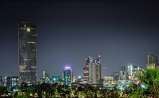
Hawassa known historically as Adare is a city in Ethiopia, on the shores of Lake Hawassa in the Great Rift Valley. It is 273 km (170 mi) south of Addis Ababa via Bishoftu, 130 km (81 mi) east of Sodo, and 75 km (47 mi) north of Dilla. The town serves as the capital of the Sidama Region. It lies on the Trans-African Highway 4 Cairo-Cape Town and has a latitude and longitude of 7°3′N38°28′E and an elevation of 1,708 meters (5,604 ft) above sea level. Its name comes from a Sidamic word meaning "wide body of water".

Moyale is a city situated on the border between Ethiopia and Kenya. In Ethiopia, it serves as the administrative centre for two Ethiopian woredas: Moyale of the Oromia Region and Moyale of the Somali Region. In Kenya, it is the largest town in Marsabit County and the capital of Moyale sub-county.

Kombolcha is a town and district in north-central Ethiopia. Located in the Debub Wollo Zone of the Amhara Region, it has a latitude and longitude of 11°5′N39°44′E with an elevation between 1842 and 1915 meters above sea level. Some guide books describe Kombolcha as the twin town of Dessie which lies some 12 kilometres (7.5 mi) to the northwest.
In India and some other countries, a well developed village is designated as a village where all basic facilities like health, education road connectivity, rail connectivity and other basic infrastructure is easily available.
Dabat is a woreda in Amhara Region, Ethiopia. Part of the Semien Gondar Zone, Dabat is bordered on the south by Wegera, on the west by Tach Armachiho, on the northwest by Tegeda, and on the northeast by Debarq. Towns in Dabat include Dabat and Wekin.
Lay Armachiho is a woreda in Amhara Region, Ethiopia. This woreda is named after "Armachiho", a province in northwestern Ethiopia along the border with Sudan and south of the Tekezé River. Part of the Semien Gondar Zone, Lay Armachiho is bordered on the south by Dembiya, on the west by Chilga, on the north by Tach Armachiho, on the east by Wegera, and on the southeast by Gondar Zuria. The administrative center of this woreda is Tekle Dingay.
Dangila is one of the woredas in the Amhara Region of Ethiopia. This woreda is named after the former district, Dangila, which James Bruce notes was in his day known for its breed of sheep. Part of the Agew Awi Zone, Dangila is bordered on the south by Faggeta Lekoma, on the southwest by Guangua, on the northwest by the Jawi, and on the northeast by the Mirab Gojjam Zone. Towns in Dangila include Addis Alem, Dangila and Dek. Part of the Dangila was separated to create Jawi woreda.
Bako Tibe is one of the Aanaas, or districts, in the Oromia region of Ethiopia. Part of the West Shewa Zone, Bako Tibe is bordered on the south and west by the East Welega Zone, on the north by Horo Gudru Welega Zone, and on the east by Cheliya. The administrative center of this woreda is Bako; other towns in Bako Tibe include Tibe and Shoboka.
Lalo Asabi is one of the 180 districts in the Oromia of Ethiopia. Part of the West Welega Zone, Lalo Asabi is bordered on the south by Yubdo, on the west by Ayra Guliso, on the north by Boji, on the east by the Benishangul-Gumuz Region, and on the southeast by Gimbi. The administrative center of this woreda is Inango; other towns in Lalo Asabi include Dongoro.

Access to water supply and sanitation in Ethiopia is amongst the lowest in Sub-Saharan Africa and the entire world. While access has increased substantially with funding from foreign aid, much still remains to be done. Some factors inhibiting the achievement of these goals are the limited capacity of water bureaus in the country's nine regions, two city administrations and water desks in the 770 districts of Ethiopia (woredas); insufficient cost recovery for proper operation and maintenance; and different policies and procedures used by various donors, notwithstanding the Paris Declaration on Aid Effectiveness.
Wukro is a small town and separate woreda in Tigray, Ethiopia. The population of Wukro was around 50,000 in 2013. Wukro is located along Genfel River, in the Eastern Zone of the Tigray Region on the Asmara-Addis Ababa highway. Wukro is surrounded by Kilte Awulaelo woreda. The rock-hewn churches around Wukro are the town's most distinctive landmarks. Visually it can be characterised by one main road, few cars, yet many bajaj and hotels under construction. Hotels have been growing to serve conferences and to accommodate tourists departing to regional attractions.
Char char is one of the Aanaas in the Oromia Region of Ethiopia. It is part of the West Hararghe Zone. It was separated from Guba Koricha Aanaa.

The Oromia Special Zone Surrounding Finfinne is a zone in Oromia Region of Ethiopia that surrounds Addis Ababa. It was created in 2008 from parts of North Shewa Zone, East Shewa Zone, Southwest Shewa zone and West Shewa Zones. The zone was created to support the cooperation and development of the surrounding areas of Addis Ababa, and to control the urban sprawl of the city on the lands of Oromia. The administrative center of this zone is in Addis Ababa (Finfinne). The districts and town in this zone include Akaki, Bereh, Burayu, Dubra, Holeta Town, Koye Feche, Mulo, Sebeta Hawas, Sebeta Town, Sendafa Town, Sululta, Walmara, Laga Xafo Laga Dadhi, Galaan, Sebeta Hawas (Town) and Dukem.
Burayu is a city and special census zone in the Oromia Region of Ethiopia, located directly adjacent to the national capital city Addis Ababa. With the rapid growth of the capital in recent decades and urban sprawl, the town has faced considerable economic and demographic pressures. The city's population has grown from merely 10,000 people in 1994 to an estimated 130,000 people three decades later; consisting of migrants from the rural south of Ethiopia looking for work along with former residents of Addis Ababa who sought cheaper housing in the surburbs.

Bale Hawassa(Wolaytta: Bale Hawaassa) or in short Bale is a city in Wolayita Zone of South Ethiopia Regional State, Ethiopia. The city is one of seven city administrations in Wolaita Zone. It is administrative capital of Kindo Koysha district of Wolayita Zone, Ethiopia. Bale is located about 400 km away from Addis Ababa to the south on the path Addis-Butajira-Sodo and 38 km westward from Sodo, the capital of Wolaita Zone. The city has an average elevation 1500 meter above sea level. Bale Hawassa lies between 6°55'05" North, and 37°31'55" East.
