Sarasota County is a county located in Southwest Florida. At the 2020 US census, the population was 434,006. Its county seat is Sarasota and its largest city is North Port. Sarasota County is part of the North Port–Bradenton–Sarasota, FL metropolitan statistical area. The county includes barriers islands with beaches and beach communities. It is home to colleges, a network of libraries, and various parks and preserves. Hurricane Milton made landfall in the county in 2024.

Longboat Key is a town in Manatee and Sarasota counties along the central west coast of the U.S. state of Florida, located on and coterminous with the barrier island of the same name. Longboat Key is south of Anna Maria Island, between Sarasota Bay and the Gulf of Mexico. It is almost equally divided between the Manatee and Sarasota counties. The town of Longboat Key was incorporated in 1955 and is part of the North Port-Bradenton-Sarasota, Florida Metropolitan Statistical Area. The town's population was 7,505 at the 2020 census, up from 6,888 at the 2010 census.
Sarasota is a city in and the county seat of Sarasota County, Florida, United States. It is located in Southwest Florida, the southern end of the Greater Tampa Bay Area, and north of Fort Myers and Punta Gorda. Its official limits include Sarasota Bay and several barrier islands between the bay and the Gulf of Mexico. Sarasota is a principal city of the North Port-Bradenton-Sarasota, FL Metropolitan Statistical Area. According to the 2020 U.S. census, Sarasota had a population of 54,842, up from 51,917 at the 2010 census.

Biscayne Bay is a lagoon with characteristics of an estuary located on the Atlantic coast of South Florida. The northern end of the lagoon is surrounded by the densely developed heart of the Miami metropolitan area while the southern end is largely undeveloped with a large portion of the lagoon included in Biscayne National Park.

The Venetian Causeway crosses Biscayne Bay between Miami on the mainland and Miami Beach on a barrier island in the Miami metropolitan area. The man-made Venetian Islands and non-bridge portions of the causeway were created by materials which came from the dredging of the bay. The Venetian Causeway follows the original route of the Collins Bridge, a wooden 2.5 mi (4 km) long structure built in 1913 by John S. Collins and Carl G. Fisher which opened up the barrier island for unprecedented growth and development.

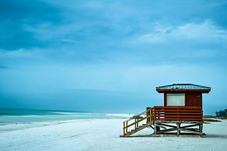
Southwest Florida is the region along the southwest Gulf coast of the U.S. state of Florida. The area is known for its beaches, subtropical landscape, and winter resort economy.
Lido Key is a barrier island off the coast of Sarasota, Florida, in the United States. It is part of the city of Sarasota and is connected to mainland Sarasota by John Ringling Causeway.

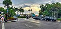
St. Armands Key is an island in Sarasota Bay off the west coast of Florida in the United States. It is part of the city of Sarasota, Florida. The island is connected to the mainland by the John Ringling Causeway.

State Road 789 is a 17.5-mile-long road along the Florida’s Gulf Coast that spans Bird Key, St. Armands Key, and Lido Key, in Sarasota; Longboat Key ; and Anna Maria Island. The southern terminus is the intersection of the John Ringling Causeway and Tamiami Trail in Sarasota; the northern terminus is the intersection of Gulf Drive, North and Manatee Avenue., West in Holmes Beach. Much of the northernmost five miles (8 km) has been designated Bradenton Beach Scenic Highway.
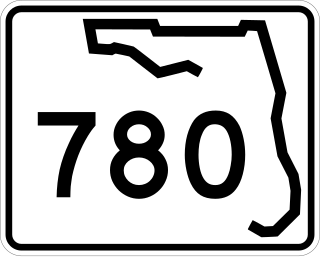
State Road 780, known as Fruitville Road, is a 5-mile-long (8.0 km) east–west street in Sarasota, Florida. The western terminus is an intersection with US 301/SR 683. The eastern terminus is east of an interchange with Interstate 75 in Fruitville, where the road continues east as County Road 780. West of US 301, Fruitville Road extends one mile (1.6 km) west of the end of SR 780, ending at an intersection with the Tamiami Trail in Downtown Sarasota.

Hutchinson Island consists of two barrier islands on the coast of Martin, St. Lucie, and Indian River counties, in Florida. The two islands are separated by the Fort Pierce Inlet and are known as "North Hutchinson Island" and "South Hutchinson Island".
The following is an alphabetical list of articles related to the U.S. state of Florida.
Bird Key is a barrier island in Sarasota Bay, south of the John Ringling Causeway, between mainland Sarasota and St. Armands Key. Originally a small barrier island connected to the Ringling Causeway by a tree lined causeway of its own, it was the home of John Ringling North, nephew of circus magnate John Ringling. Created by dredge and fill in the late 1950s, it is approximately 250 acres (1.0 km2) of one of the most prestigious residential areas on Florida's West Coast.

Owen Burns was an American entrepreneur, banker, builder, and land developer who at one time owned the majority of the land comprising Sarasota, Florida. He developed or built many of its historic structures, developments, roads, seawalls, and bridges. He became a leader in the community, contributing to its growth and development. He was born in Fredericktown in Cecil County on the Eastern Shore of Maryland.
Dwight James Baum was an American architect most active in New York and in Sarasota, Florida. His work includes Cà d'Zan, the Sarasota Times Building (1925), Sarasota County Courthouse (1926), early residences in Temple Terrace, Florida, Sarasota County Courthouse (1927), Pinecroft, West Side YMCA on 63rd Street between Central Park and Columbus Avenue, Columbus Circle (1934) and Hendricks Memorial Chapel.

Thomas Reed Martin was an architect who was brought to Florida by one of its major developers during the turn of the twentieth century. He designed some 500 residences and various public and private buildings in Sarasota, as well as commercial buildings. His Florida buildings are located from Tampa to Fort Myers with many in Nokomis.

John Ringling Causeway is a causeway that extends past the Sarasota Bay, from Sarasota to St. Armands Key and Lido Key. The 65-foot-tall (20 m) bridge, built in 2003, is a segmental box girder bridge running from Sarasota to Bird Key. Another short bridge carries the causeway from Bird Key to Coon Key and St. Armand's Key. The causeway is named after John Ringling, one of the founders of the Ringling Brothers Circus and resident of the Sarasota area.
The earliest known identification of the area known today as Sarasota, Florida, was identified on a sheepskin Spanish map from 1763 with the word "Zarazote" written over the location of present-day Sarasota and Bradenton. A 1776 British map by Bernard Romans lists a "Boca Sarasota" in the local area.

The Hiss Residence is a mid-century modern home designed by architect, Paul Rudolph. Built as the show home for Sarasota's Lido Shores neighborhood in 1953, the structure blends international style modernism with indigenous tropical design. It is among the preeminent works of the Sarasota School of Architecture and considered “one of the most remarkable homes of the twentieth century.”