Hardy County is a county in the U.S. state of West Virginia. As of the 2020 census, the population was 14,299. Its county seat is Moorefield. The county was created from Hampshire County in 1786 and named for Samuel Hardy, a distinguished Virginian.

Aldine is a census-designated place (CDP) in unincorporated central Harris County, Texas, United States, located within the extraterritorial jurisdiction of Houston. The population was 15,999 at the 2020 census. The community is located on the Hardy Toll Road, Union Pacific Railroad, and Farm to Market Road 525. The Aldine area is near Houston's George Bush Intercontinental Airport, the second largest aviation facility in Texas.

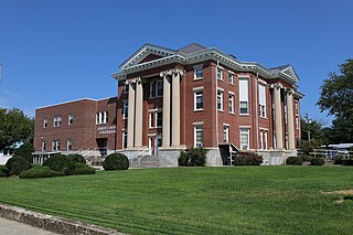
Moorefield is a town and the county seat of Hardy County, West Virginia, United States. It is located at the confluence of the South Branch Potomac River and the South Fork South Branch Potomac River. Moorefield was originally chartered in 1777; it was named for Conrad Moore, who owned the land upon which the town was laid out. The population was 2,527 at the 2020 census.

The South Branch Potomac River has its headwaters in northwestern Highland County, Virginia near Hightown along the eastern edge of the Allegheny Front. After a river distance of 139 miles (224 km), the mouth of the South Branch lies east of Green Spring in Hampshire County, West Virginia where it meets the North Branch Potomac River to form the Potomac.

U.S. Route 48 (US 48), also known as the incomplete Corridor H of the Appalachian Development Highway System, extends from Interstate 79 (I-79) in Weston, West Virginia, eastward across the crest of the Allegheny Mountains to I-81 in Strasburg, Virginia. It is planned to extend 157 miles (253 km) from northwestern Virginia to central West Virginia.

Upper Kirby is a commercial district in Houston, Texas, United States. It is named after Kirby Drive, so indirectly takes its name from John Henry Kirby.

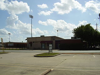
César E. Chávez High School is a secondary school located at 8501 Howard Drive in the Allendale neighborhood in Houston, Texas, United States.
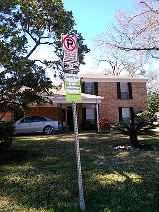
University Oaks is a subdivision in southeast Houston with approximately 240 homes located adjacent to the University of Houston. It is bounded by Wheeler Avenue to the north, South MacGregor Way to the south, Calhoun Road to the east, and Cullen Boulevard to the west.

Memphis City Schools (MCS) was the school district operating public schools in the city of Memphis, Tennessee, United States. It was headquartered in the Frances E. Coe Administration Building. On March 8, 2011, residents voted to disband the city school district, effectively merging it with the Shelby County School District. The merger took effect July 1, 2013. After much legal maneuvering, all six incorporated municipalities created separate school districts in 2014. Total enrollment, as of the 2010-2011 school year, was about 103,000 students, which made the district the largest in Tennessee.
Galena Park Independent School District is a school district based in the Channelview CDP of unincorporated Harris County, Texas, United States.
Near Northside is a historic neighborhood located in Northside, Houston, Texas. Near Northside is primarily occupied by people of Hispanic descent.
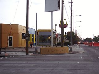
East End Houston, managed by the East End District (EED), is a district in eastern Houston, Texas, United States, located between the eastern edge of downtown to the Port of Houston and South to Hobby Airport. The District is home to Houston's early history and industry and is the site of Harrisburg, the seat of government for the Republic of Texas in 1836. East End Houston consists of many different ethnic groups, including Hispanic, Asian, White, and African American. Latinos make up more than half of the 100,512 residents, The area includes two of Houston's oldest Hispanic neighborhoods, Magnolia Park and Second Ward.

Moorefield Township is one of the ten townships of Clark County, Ohio, United States. The population as of the 2020 census was 12,622.
The Leflore County School District (LCSD) was a public school district headquartered in Greenwood, Mississippi, United States.

East Downtown Houston (EaDo) is a district in Houston, Texas. The East Downtown Management District (EDMD), manages the area with offices headquartered at START Houston, a co-working space 1121 Delano Street. The community is located east of Downtown Houston and north of Interstate 45. It is between the George R. Brown Convention Center and the East End district.
Port Houston is a neighborhood located on the East Side of Houston, Texas, United States.

Dora B. Lantrip Elementary School is a primary school at 100 Telephone Road in the Eastwood community in the East End region of Houston, Texas, United States. The school is within the Houston Independent School District (HISD).

East Aldine is a state management district in Harris County, Texas, United States, mostly in unincorporated areas with some territory in the City of Houston. The East Aldine Improvement District, also known as the Aldine Management District, governs the area. Portions of the district coincide with the boundaries of the Aldine census-designated place. One park owned by the City of Houston, Keith-Wiess Park, is within the district limits.

Moorefield High School is a high school located in Hardy County, West Virginia. It is one of two high schools located within Hardy County, the other being East Hardy High School. Moorefield High School was built in the late 1930s. Moorefield's colors are blue and gold and their mascot is the Yellowjackets, one among two schools in West Virginia to use this mascot.


