
The West End of London is a district of Central London, London, England, west of the City of London and north of the River Thames, in which many of the city's major tourist attractions, shops, businesses, government buildings and entertainment venues, including West End theatres, are concentrated.

The Jubilee line is a London Underground line that runs between Stanmore in suburban north-west London and Stratford in east London, via the Docklands, South Bank and West End. Opened in 1979, it is the newest line on the Underground network, although some sections of track date back to 1932 and some stations to 1879.

Burgess Park is a public park situated in Camberwell in the London Borough of Southwark. It is close to Walworth to the north, Bermondsey to the east and Peckham to the south. At 56 hectares, it is one of the largest parks in South London.

The London Borough of Islington is short of large parks and open spaces, given its status in recent decades as a desirable place of residence. In fact, Islington has the lowest ratio of open space to built-up areas of any London borough. The largest continuous open space in the borough, at 11.75 hectares, is Highbury Fields.

The A202 is a primary A road in London. It runs from New Cross Gate to London Victoria station. A section of the route forms a part of the London Inner Ring Road between Vauxhall and Victoria, known as Vauxhall Bridge Road.

Bedford Park is a suburban development in Chiswick, London, begun in 1875 under the direction of Jonathan Carr, with many large houses in British Queen Anne Revival style by Norman Shaw and other leading Victorian era architects including Edward William Godwin, Edward John May, Henry Wilson, and Maurice Bingham Adams. Its architecture is characterised by red brick with an eclectic mixture of features, such as tile-hung walls, gables in varying shapes, balconies, bay windows, terracotta and rubbed brick decorations, pediments, elaborate chimneys, and balustrades painted white.

Pymmes Park is located in Edmonton, London and is bordered by the North Circular Road.

Kenaston is a village in the Canadian province of Saskatchewan within the Rural Municipality of McCraney No. 282 and Census Division No. 11. Kenaston is located on Highway 11 at the junction of Highway 15 and is also near Highway 19. This is a scenic area of Saskatchewan situated within the rolling Allan Hills. Kenaston is located between Danielson Provincial Park and Blackstrap Provincial Park.

East Greenwich Pleasaunce is a public park in East Greenwich, in south-east London. It is situated to the north side of the railway line between Maze Hill and Westcombe Park railway stations and south of the A206 Woolwich Road.

Nine Elms railway station was located in Nine Elms and opened on 21 May 1838 as the London terminus of the London and Southampton Railway, which later became the London and South Western Railway. The building in the neoclassical style was designed by Sir William Tite. The station was inconveniently situated for travel to central London, with the necessity to complete the journey by road or by the steam boats connecting the station to points between Vauxhall and London Bridge.
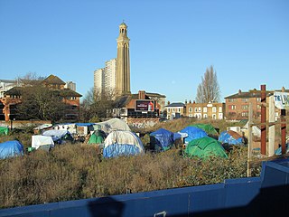
Kew Bridge Ecovillage was an ecovillage and social centre in Brentford on squatted land overlooking the River Thames at the north end of Kew Bridge in west London.

Onslow Square is a garden square in South Kensington, London, England.

Ladbroke Square is a garden square in Notting Hill, west London, England.
Chiswick Park Cricket Ground was a cricket ground in Chiswick, London. The first recorded match on the ground was in 1886, when Chiswick Park played the Parsees during their tour of England.

Powis Square is a garden square and locality in Notting Hill, in the Royal Borough of Kensington and Chelsea in London, England. The closest London Underground station to the square is Westbourne Park tube station.
Greenhill Gardens is a 1.6 hectare public park in New Barnet in the London Borough of Barnet. Its main feature is an ornamental lake with a wooded island, which attracts many birds, and it also has a grassed area with scattered mature trees. It is a site of local importance for nature conservation.
Bonnington Square is a square in Vauxhall, south London, which was built in the 1870s. It became famous in the 1980s when all the houses in it, vacant and awaiting demolition, were squatted, and the community formed continues to the present day.
Ravensbury Park is a public park in Mitcham in the London Borough of Merton. An area of 7 hectares is designated a Local Nature Reserve. The River Wandle runs along the southern boundary of the park, which is also part of the Upper Wandle River Site of Metropolitan Importance for Nature Conservation.
This is a list of the toponymy of street names in the London district of Vauxhall. The area has no formally defined boundaries – those utilised here are Black Prince Road to the north, Kennington Road to the north-east, Kennington Park Road/Clapham Road to the south-east, Miles Street/Fentiman Road to the south, and Wandsworth Road/Nine Elms Lane/river Thames to the west.

Oval Mansions are eight separate blocks of tenement housing in Kennington, south London. The blocks stand between the Oval cricket ground and the Oval Gasholders. After being occupied by 100 squatters from 1983 until 2000, the buildings were sold off by Lambeth Council in the early 2000s.

