
George Harrison was an English musician, singer and songwriter who achieved international fame as the lead guitarist of the Beatles. Sometimes called "the quiet Beatle", Harrison embraced Indian culture and helped broaden the scope of popular music through his incorporation of Indian instrumentation and Hindu-aligned spirituality in the Beatles' work.

Berkeley Plantation, one of the first plantations in America, comprises about 1,000 acres (400 ha) on the banks of the James River on State Route 5 in Charles City County, Virginia. Berkeley Plantation was originally called Berkeley Hundred, named after the Berkeley Company of England. In 1726, it became the home of the Harrison family of Virginia, after Benjamin Harrison IV located there and built one of the first three-story brick mansions in Virginia. It is the ancestral home of two presidents of the United States: William Henry Harrison, who was born there in 1773 and his grandson Benjamin Harrison. It is now a museum property, open to the public.
Michael Edward Harrison in Barnsley, West Riding of Yorkshire) is a former first-class rugby union footballer, playing on the wing for Wakefield and England.

"Do You Want to Know a Secret" is a song by English rock band the Beatles from their 1963 album Please Please Me, sung by George Harrison. In the United States, it was the first top ten song to feature Harrison as a lead singer, reaching No. 2 on the Billboard chart in 1964 as a single released by Vee-Jay, VJ 587. In the UK, Billy J. Kramer released a cover of the song as his debut single, reaching No. 1 on the NME singles chart and No. 2 on the Record Retailer chart.

Bronson Harrison is a New Zealand former professional rugby league footballer who played as a second-row forward in the 2000s and 2010s. He played for the Wests Tigers, Canberra Raiders and the St. George Illawarra Dragons in the NRL and represented the New Zealand Kiwis at international level, being a part of the 2008 World Cup winning squad.

The New Zealand women's national field hockey team is also known as the Black Sticks Women. The team's best performances include a gold medal at the 2018 Commonwealth Games, silver medal at the 2010 Commonwealth Games, a third placing at the 2011 Champions Trophy, and fourth placings at the 1986 World Cup, 2012 Summer Olympics and 2016 Summer Olympics. As of Jun 2024, the team ranks 11th on the International Hockey Federation (FIH) world rankings.

Anna Maree Harrison, originally known as Anna Scarlett, is a former New Zealand netball international. She was a member of the New Zealand teams that won gold medals at the 2003 World Netball Championships and 2006 and 2010 Commonwealth Games. During the National Bank Cup era, she played for Otago Rebels and Auckland Diamonds. During the ANZ Championship era, she played for Northern Mystics. In 2012, Harrison began using a rugby union lineout-style form of goaltending. The technique subsequently became known as the Harrison Hoist. During the ANZ Premiership era, she played for Mystics and Northern Stars. As well as playing international netball, Harrison also played for the New Zealand women's national volleyball team and represented New Zealand on the FIVB Beach Volleyball World Tour. In 2022, she was included on a list of the 25 best players to feature in netball leagues in New Zealand since 1998. In 2023, Harrison was appointed a Member of the New Zealand Order of Merit, for services to netball and volleyball.
Grey Valley is a former parliamentary electorate in the West Coast region of New Zealand. The electorate was created for the 1871 general election as a single-member electorate, became a two-member electorate for the 1876 general election, and was split between the single-member electorates of Greymouth and Inangahua for the 1881 general election.

Lulu is an eponymous album released by Lulu on Alfa Records in 1981. It is notable for containing the hit single "I Could Never Miss You ", which became the second-highest-charting single of Lulu's career in the US, hitting the top 20 on the Billboard Hot 100 and No. 2 on the Adult Contemporary chart in 1981.

West Hudson is the western part of Hudson County, New Jersey comprising the contiguous municipalities of Kearny, Harrison and East Newark, which lies on the peninsula between the Hackensack River and Passaic River.
William Henry Harrison was a 19th-century journalist from Greymouth who represented two Westland electorates in the New Zealand House of Representatives.
Kerrin Charters Harrison is a New Zealand badminton player.

Jenny Harrison is a fictional character on the New Zealand soap opera Shortland Street. She was portrayed by Maggie Harper as part of the show's original cast, making her first appearance in the second episode. Harper quit the role in 1998 but reprised the character briefly 4 years later.

Waverley "Wave" Harrison is a fictional character on the New Zealand soap opera Shortland Street. She was portrayed by Claire Chitham and was introduced as a love interest for Nick Harrison who she eventually married eight years after her arrival to the show. The character returned along with husband Nick for the show's 25th anniversary episode that aired on 25 May 2017. Waverley also returned with Lucas and three of her and Nick's children for the 2022 finale.
Charlotte Harrison is a New Zealand field hockey player. She has competed for the New Zealand women's national field hockey team, including for the team at the 2012 and 2016 Summer Olympics and at the 2006 and 2010 Commonwealth Games, and as a reserve for the team at the 2008 Summer Olympics.

Mount Harrison, at 9,265 feet (2,824 m) is a peak in the northern Albion Mountains of Cassia County in southern Idaho. Mount Harrison is located in north of Cache Peak, south of Burley, northeast of Oakley, and west of Malta in the Albion Division of the Minidoka Ranger District of Sawtooth National Forest. Mount Harrison is in the watershed of tributaries of the Snake River, which itself is a tributary of the Columbia River. The peak can be reached via a paved road that runs all the way to its summit. Lake Cleveland is located in the basin north of the peak, and a small unnamed lake is located in the basin southeast of the peak.

Samantha (Sam) Harrison is a New Zealand field hockey player. She has competed for the New Zealand women's national field hockey team, including for the team at the 2010 Commonwealth Games and the 2012 Summer Olympics.
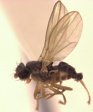
Australimyzidae is a family of flies (Diptera). There is 1 genus, containing 9 known species known from Australia and New Zealand and subantarctic surrounding islands. They have saprophagous larvae.
The Westland Boroughs by-election 1868 was a by-election held in the Westland Boroughs electorate during the 4th New Zealand Parliament, on 3 April 1868.

