Related Research Articles
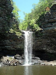
Petit Jean State Park is a 3,471-acre park in Conway County, Arkansas managed by the Arkansas Department of Parks and Tourism. It is located atop Petit Jean Mountain adjacent to the Arkansas River in the area between the Ouachita Mountains and Ozark Plateaus.

The Narrows is the narrowest section of Zion Canyon in Zion National Park, Utah, United States. Situated on the North Fork of the Virgin River and upstream of the main canyon, The Narrows is one of the premier hikes in the park and on the Colorado Plateau. The Narrows refers to both the 3.6-mile (5.8 km) bottom-up hike from the Temple of Sinawava to Big Springs, as well as the 16-mile (26 km) top-down hike from Chamberlain's Ranch back to the Temple of Sinawava.
Zion Canyon is a deep and narrow gorge in southwestern Utah, United States, carved by the North Fork of the Virgin River. Nearly the entire canyon is located within the western half of Zion National Park.

This is a directory of properties and districts listed on the National Register of Historic Places in Utah, USA. There are more than 1,800 listed properties in Utah. Each of the 29 counties in Utah has at least two listings on the National Register.

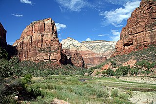
Angels Landing, known previously as the Temple of Aeolus, is a 1,488-foot (454 m) tall rock formation in Zion National Park in southwestern Utah, United States. A trail cut into solid rock in 1926 leads to the top of Angels Landing and provides views of Zion Canyon.

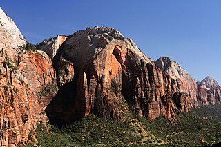
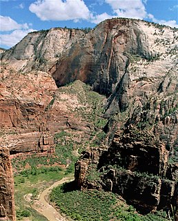
Zion National Park is an American national park located in southwestern Utah near the town of Springdale. A prominent feature of the 229-square-mile (590 km2) park is Zion Canyon, which is 15 miles (24 km) long and up to 2,640 ft (800 m) deep. The canyon walls are reddish and tan-colored Navajo Sandstone eroded by the North Fork of the Virgin River. The lowest point in the park is 3,666 ft (1,117 m) at Coalpits Wash and the highest peak is 8,726 ft (2,660 m) at Horse Ranch Mountain. Located at the junction of the Colorado Plateau, Great Basin, and Mojave Desert regions, the park has a unique geography and a variety of life zones that allow for unusual plant and animal diversity. Numerous plant species as well as 289 species of birds, 75 mammals, and 32 reptiles inhabit the park's four life zones: desert, riparian, woodland, and coniferous forest. Zion National Park includes mountains, canyons, buttes, mesas, monoliths, rivers, slot canyons, and natural arches.

The Floor of the Valley Road, also known as the Zion Canyon Scenic Drive, follows the canyon of the North Fork of the Virgin River, also known as Zion Canyon, through Zion National Park, Utah, USA. A precursor to the present nine-mile road was first built in 1916, but was later redesigned by the National Park Service Branch of Plans and Designs to highlight the natural features of the valley while presenting a natural-appearing built environment. The road begins at the south boundary of the park and ends at the Temple of Sinawava.

The Zion – Mount Carmel Highway is a 25-mile (40 km) long road in Washington and Kane counties in southern Utah, United States, that is listed on the National Register of Historic Places.

The historical buildings and structures of Zion National Park represent a variety of buildings, interpretive structures, signs and infrastructure associated with the National Park Service's operations in Zion National Park, Utah. Structures vary in size and scale from the Zion Lodge to road culverts and curbs, nearly all of which were designed using native materials and regional construction techniques in an adapted version of the National Park Service Rustic style. A number of the larger structures were designed by Gilbert Stanley Underwood, while many of the smaller structures were designed or coordinated with the National Park Service Branch of Plans and Designs. The bulk of the historic structures date to the 1920s and 1930s. Most of the structures of the 1930s were built using Civilian Conservation Corps labor.
The Central Design Office, Ames was a design office at Iowa State, in Ames, Iowa that designed public works, many built under the Civilian Conservation Corps program. It designed many that are listed on the U.S. National Register of Historic Places.
This is a list of the National Register of Historic Places listings in Zion National Park.
Scott & Welch was an architectural partnership of Carl W. Scott and George W. Welch that was based in Salt Lake City, Utah and began in 1914. They designed schools, libraries, and other buildings that were built by New Deal programs. A number of their works are listed on the U.S. National Register of Historic Places (NRHP).

The Midland Bridge Company is a firm based in Kansas City, Missouri, United States, that has built numerous bridges. Several of its works are listed on the U.S. National Register of Historic Places (NRHP).

The Groton Bridge Co. was an American construction company.

The Omaha Structural Steel Works was a company also known as Omaha Steel Works and as Omaha Structural Steel Bridge Co.
Architects of the National Park Service are the architects and landscape architects who were employed by the National Park Service (NPS) starting in 1918 to design buildings, structures, roads, trails and other features in the United States National Parks. Many of their works are listed on the National Register of Historic Places, and a number have also been designated as National Historic Landmarks.

The Watchman is a 6,545-foot (1,995 m) sandstone mountain summit located in Zion National Park, in Washington County of southwest Utah, United States.

Mount Kinesava is a 7,285-foot (2,220 m) sandstone mountain summit located in Zion National Park, in Washington County of southwest Utah, United States.
Red Arch Mountain is a 5,930-foot (1,810 m) elevation Navajo Sandstone summit located in Zion National Park, in Washington County of southwest Utah, United States. Red Arch Mountain is situated immediately northeast of Zion Lodge, towering 1,700-feet above the lodge and the floor of Zion Canyon. It is set on the east side of the North Fork Virgin River which drains precipitation runoff from this mountain. Its neighbors include Mount Majestic, Cathedral Mountain, The Great White Throne, Mountain of the Sun, Mount Moroni, and Lady Mountain. This mountain's descriptive name was officially adopted in 1934 by the U.S. Board on Geographic Names. It is so named for a blind arch that formed in 1880 on the northwest face when a rock avalanche fell into the valley. This event buried the Gifford farm in rubble. It happened on a Sunday when the family was away at church in Springdale.
Cable Mountain is a 6,940-foot (2,120 m) elevation Navajo Sandstone summit located in Zion National Park, in Washington County of southwest Utah, United States. Towering 2,600-feet above the floor of Zion Canyon at the Big Bend area, Cable Mountain is situated immediately northeast of The Great White Throne, separated by the chasm of Hidden Canyon. It is set on the east side of the North Fork Virgin River which drains precipitation runoff from this mountain. Its neighbors include Angels Landing, Cathedral Mountain, The Organ, and Observation Point. This mountain's name was officially adopted in 1934 by the U.S. Board on Geographic Names. It is so named in association with the draw-works which used cables to lower timber from the top of the plateau down to the valley bottom from 1901 through 1927. Wood to construct the Zion Lodge came down the cable works. A 7.4-mile trail, much of it an old wagon road, leads to the views from the top.
References
| This article about a United States architect or architectural firm is a stub. You can help Wikipedia by expanding it. |