Kshatriya is one of the four varna of Hindu society, associated with warriorhood. The Sanskrit term kṣatriyaḥ is used in the context of Vedic society wherein members were organised into four classes: brahmin, kshatriya, vaishya and shudra.

Khatri is a predominantly Hindu caste of northern India and Pakistan, mostly from the Punjab region, that provided many significant figures in Sikhism, including all of the Sikh Gurus.
The caste system in Kerala differed from that found in the rest of India. While the Indian caste system generally modelled the four-fold division of society into Brahmins, Kshatriyas, Vaishyas and Shudras, in Kerala the Nambudiri Brahmins formed the priestly class and only rarely recognised anyone else as being other than Shudra or untouchables outside the caste system entirely. Thus, the Kerala caste system was ritualised but it was not the varna model found elsewhere. Even inside Kerala, North Kerala castes are different from South Kerala. Until the recent past, they did not follow marriage alliances, citing the differences.

Mandapeta, also called as Mandavyapuram is a town and an A-grade municipality in East Godavari district in the Indian state of Andhra Pradesh. It is a market place and a place of recreation for many surrounding villages and it is famous for its rice mills.
The Vanniyar, also spelled Vanniya, who were once known as the Palli, are a community or jāti found in Southern India.
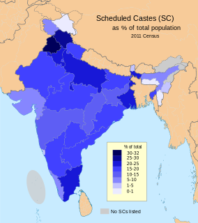
Jatav, also known as Jatva/ Jatan/ Jatua/ Jatia, is a social group that in India.who are classified as a Scheduled Caste under modern India's system of positive discrimination.

Yadav refers to a grouping of traditionally mainly non-elite, peasant-pastoral communities or castes in India that since the 19th and 20th centuries have claimed descent from the mythological king Yadu as a part of a movement of social and political resurgence.

Bamshore is a village in Bhatar CD Block in Bardhaman Sadar North subdivision of Purba Bardhaman district in West Bengal, India.
Aripanthan is a village and panchayat halqa in Beerwah tehsil of Budgam district in Indian State of Jammu and Kashmir. Aripanthan is situated at the centre of tehsil Beerwah and tehsil Magam.It is located about 27 km west from state's summer capital Srinagar and about 28 km north from district headquarters in Budgam.

Sultanpur is a medium size village in Phillaur tehsil of Jalandhar District of Punjab State, India. It is located 3 km from census town Apra, 48 km from Jalandhar through Dhuleta-Apra road and 124 km from state capital Chandigarh. Sultanpur has postal head office in Dayalpur which is 2 km away from the village. The village is administrated by a sarpanch who is an elected representative of village as per Panchayati raj (India).

Tehang is a large village in Phillaur tehsil of Jalandhar District of Punjab State, India. The village is administrated by Sarpanch who is the elected representative of village and it is located 3.2 km away from Nagar, 8.5 km from census town Apra, 43.5 km from Jalandhar and 120 km from state capital Chandigarh. Tehang has postal head office in Phillaur which is 7.4 km away from the village.

Shahpur is a medium size village in Phillaur tehsil of Jalandhar District of Punjab State, India. It is located 7.7 km away from Goraya, 41 km from Jalandhar and 122 km from state capital Chandigarh. Shahpur has postal head office in Phillaur which is 11 km away from the village. The village is administrated by Sarpanch who is the elected representative of village.

Bachhowal is a medium size village in Phillaur tehsil of Jalandhar District of Punjab State, India. It is located 9.5 km away from Goraya, 43 km from Jalandhar and 117 km from state capital Chandigarh. Bachhowal has postal head office in Bara Pind which is 10 km away from the village. The village is administrated by a sarpanch who is an elected representative of village as per Panchayati raj (India).

Nurewal is a village in Phillaur tehsil of Jalandhar District of Punjab State, India. It is located 2.8 km away from Nagar, 45 km from Jalandhar and 116 km from state capital Chandigarh. Nurewal has postal head office in Phillaur which is 5.3 km away from the village. The village is administrated by a sarpanch who is an elected representative of village as per Panchayati raj (India).

Raipur Sagnewal is a village in Phillaur tehsil of Jalandhar District of Punjab State, India. It is located 2 km away from Nagar, 49 km from Jalandhar and 117 km from state capital Chandigarh. Raipur Sagnewal has postal head office in Phillaur which is 5.6 km away from the village. The village is administrated by a sarpanch who is an elected representative of village as per Panchayati raj (India).

Allowal is a medium size village in Phillaur tehsil of Jalandhar District of Punjab State, India. It is located 5 km away from postal head office Phillaur, 14.8 km from Goraya, 48 km from Jalandhar and 111 km from state capital Chandigarh. The village is administrated by a sarpanch who is an elected representative of village as per Panchayati raj (India).

Tarkhan Mazara or Tarkhan Majara is a medium size village in Phillaur tehsil of Jalandhar District of Punjab State, India. It is located 1;km away from postal head office Atti, 5.6 km from Phillaur, 41.9 km from district headquarter Jalandhar and 128 km from state capital Chandigarh. The village is administrated by a sarpanch who is an elected representative of village as per Panchayati raj (India).

Bakapur is a village in Phillaur tehsil of Jalandhar district of Punjab State, India. It is located 7 km away from postal head office in Phillaur, 10 km from Goraya, 41.5 km from district headquarter Jalandhar and 115 km from state capital Chandigarh. The village is administrated by a sarpanch who is an elected representative of village as per Panchayati raj (India).

Bagoran also spelled as Baghoran is a village in Shaheed Bhagat Singh Nagar district of Punjab State, India. It is located 2.7 kilometres (1.7 mi) away from postal head office Mukandpur, 11.2 kilometres (7.0 mi) from Banga, 16.8 kilometres (10.4 mi) from district headquarter Shaheed Bhagat Singh Nagar and 92.5 kilometres (57.5 mi) from state capital Chandigarh. The village is administrated by Sarpanch an elected representative of the village.

Sotran is a village in Shaheed Bhagat Singh Nagar district of Punjab State, India. It is located 9.2 kilometres (5.7 mi) away Mukandpur, 1.8 kilometres (1.1 mi) from Banga, 12 kilometres (7.5 mi) from district headquarter Shaheed Bhagat Singh Nagar and 105 kilometres (65 mi) from state capital Chandigarh. The village is administrated by Sarpanch an elected representative of the village.


