
Canada has a vast geography that occupies much of the continent of North America, sharing a land border with the contiguous United States to the south and the U.S. state of Alaska to the northwest. Canada stretches from the Atlantic Ocean in the east to the Pacific Ocean in the west; to the north lies the Arctic Ocean. Greenland is to the northeast with a shared border on Hans Island. To the southeast Canada shares a maritime boundary with France's overseas collectivity of Saint Pierre and Miquelon, the last vestige of New France. By total area, Canada is the second-largest country in the world, after Russia. By land area alone, however, Canada ranks fourth, the difference being due to it having the world's largest proportion of fresh water lakes. Of Canada's thirteen provinces and territories, only two are landlocked while the other eleven all directly border one of three oceans.

The Canadian Shield, also called the Laurentian Shield or the Laurentian Plateau, is a geologic shield, a large area of exposed Precambrian igneous and high-grade metamorphic rocks. It forms the North American Craton, the ancient geologic core of the North American continent. Glaciation has left the area with only a thin layer of soil, through which exposures of igneous bedrock resulting from its long volcanic history are frequently visible. As a deep, common, joined bedrock region in eastern and central Canada, the shield stretches north from the Great Lakes to the Arctic Ocean, covering over half of Canada and most of Greenland; it also extends south into the northern reaches of the continental United States.

Lake Ontario is one of the five Great Lakes of North America. It is bounded on the north, west, and southwest by the Canadian province of Ontario, and on the south and east by the U.S. state of New York. The Canada–United States border spans the centre of the lake.

Lake Huron is one of the five Great Lakes of North America. It is shared on the north and east by the Canadian province of Ontario and on the south and west by the U.S. state of Michigan. The name of the lake is derived from early French explorers who named it for the indigenous people they knew as Huron (Wyandot) inhabiting the region. Hydrologically, Lake Huron comprises the eastern portion of Lake Michigan–Huron, having the same surface elevation as Lake Michigan, to which it is connected by the 5-mile-wide (8.0 km), 20-fathom-deep Straits of Mackinac. Combined, Lake Michigan–Huron is the largest freshwater lake by area in the world. The Huronian glaciation was named from evidence collected from Lake Huron region. The northern parts of the lake include the North Channel and Georgian Bay. Saginaw Bay is located in the southwest corner of the lake. The main inlet is the St. Marys River from Lake Superior, and the main outlet is through the St. Clair River toward Lake Erie. Lake Huron has a fairly large drainage basin covering parts of Michigan and Ontario. Water flows through Lake Huron faster than the other Great Lakes with a retention time of only 22 years.

Hudson Bay, sometimes called Hudson's Bay, is a large body of saltwater in northeastern Canada with a surface area of 1,230,000 km2 (470,000 sq mi). It is located north of Ontario, west of Quebec, northeast of Manitoba, and southeast of Nunavut, but politically entirely part of Nunavut. It is an inland marginal sea of the Arctic Ocean. The Hudson Strait provides a connection between the Labrador Sea and the Atlantic Ocean in the northeast, while the Foxe Channel connects the Hudson Bay with the Arctic Ocean in the north. The Hudson Bay drainage basin drains a very large area, about 3,861,400 km2 (1,490,900 sq mi), that includes parts of southeastern Nunavut, Alberta, Saskatchewan, Ontario, Quebec, all of Manitoba, and parts of the U.S. states of North Dakota, South Dakota, Minnesota, and Montana. Hudson Bay's southern arm is called James Bay.

North Bay is a city in Northeastern Ontario, Canada. It is the seat of Nipissing District, and takes its name from its position on the shore of Lake Nipissing. North Bay developed as a railroad centre, and its airport was an important military location during the Cold War. The city is located 350 kilometres (220 mi) from both Ottawa and Toronto.

Kenora, previously named Rat Portage, is a city situated on the Lake of the Woods in Ontario, Canada, close to the Manitoba boundary, and about 210 km (130 mi) east of Winnipeg by road. It is the seat of Kenora District.

Thunder Bay is a city in and the seat of Thunder Bay District, Ontario, Canada. It is the most populous municipality in Northwestern Ontario and the second most populous municipality in Northern Ontario. Its population is 108,843 according to the 2021 Canadian census. Located on Lake Superior, the census metropolitan area of Thunder Bay has a population of 123,258 and consists of the city of Thunder Bay, the municipalities of Oliver Paipoonge and Neebing, the townships of Shuniah, Conmee, O'Connor, and Gillies, and the Fort William First Nation.
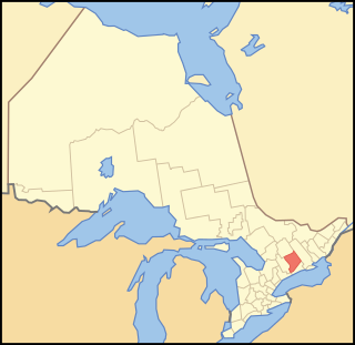
Peterborough County is located in Southern Ontario, Canada. The county seat is The City of Peterborough, which is independent of the county.

Kenora District is a district and census division in Northwestern Ontario, Canada. The district seat is the City of Kenora.

Prince Edward County (PEC) is a single-tier municipality in southern Ontario, Canada. Its coastline on Lake Ontario’s northeastern shore is known for Sandbanks Provincial Park, sand beaches, and limestone cliffs. The Regent Theatre, a restored Edwardian Opera House, sits at the heart of the town of Picton on the Bay of Quinte. Nearby Macaulay Heritage Park highlights local history through its 19th-century buildings. In 2016, Prince Edward County had a census population of 24,735. Prince Edward County is a single-tier municipality and a census division of the Canadian province of Ontario.

Thunder Bay Airport is in the city of Thunder Bay, Ontario, Canada. With 108,130 aircraft movements in 2012, it was the fourth busiest airport in Ontario and the 16th busiest airport in Canada. During the same year, more than 761,000 passengers went through the airport.

The District of Keewatin was a territory of Canada and later an administrative district of the Northwest Territories. It was created in 1876 by the Keewatin Act, and originally it covered a large area west of Hudson Bay. In 1905, it became a part of the Northwest Territories and in 1912, its southern parts were adjoined to the provinces of Manitoba and Ontario, leaving the remainder, now called the Keewatin Region, with a population of a few thousand people. On April 1, 1999, the Keewatin Region was formally dissolved, as Nunavut was created from eastern parts of the Northwest Territories, including all of Keewatin.
Air Ontario Inc. was a Canadian regional airline with its predecessor initially headquartered in Sarnia and later in London, Ontario. In 2002, Air Ontario became Air Canada Jazz.

King's Highway 61, commonly referred to as Highway 61 and historically known as the Scott Highway, is a provincially maintained highway in the Canadian province of Ontario. The 61-kilometre (38 mi) route connects the Pigeon River Bridge, where it crosses into the United States and becomes Minnesota State Highway 61, with a junction at Highway 11, Highway 17 and the Harbour Expressway in Thunder Bay. The highway forms part of the Lake Superior Circle Tour.

Lake Ojibway was a prehistoric lake in what is now northern Ontario and Quebec in Canada. Ojibway was the last of the great proglacial lakes of the last ice age. Comparable in size to Lake Agassiz, and north of the Great Lakes, it was at its greatest extent c. 8,500 years BP. The former lakebed forms the modern Clay Belt, an area of fertile land.
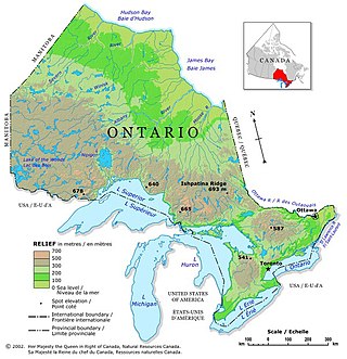
Ontario is located in East/Central Canada. It is Canada's second largest province by land area. Its physical features vary greatly from the Mixedwood Plains in the southeast to the boreal forests and tundra in the north. Ontario borders Manitoba to the west, Hudson Bay and James Bay to the north, Quebec to the east, and the Great Lakes and the United States to the south. The province is named for Great Lake Ontario, an adaptation of the Iroquois word Onitariio, meaning "beautiful lake", or Kanadario, variously translated as "beautiful water". There are approximately 250,000 lakes and over 100,000 kilometres (62,000 mi) of rivers in the province.
Mississippi Lake is a lake in Lanark County in Ontario, Canada, about 60 km southwest of Ottawa. It is a shallow and narrow lake, about 10 m deep at its deepest, 16 km in length, and less than one km wide in most places. Around the shoreline are over 1,000 homes, ranging from small cabins, to larger vacation homes, to full-time residences, many of them accessed by private roads. There are also several campground resorts, with RVs, waterfront condos, or rentals.
The 2000 Kipawa earthquake struck Quebec and Ontario, Canada with a moment magnitude of 5.2 at 6:22 a.m. on January 1. It occurred in the Western Quebec Seismic Zone. The main shock epicenter was located in Lake Kipawa about 10 km (6 mi) north of Témiscaming in southwestern Quebec and 70 km (43 mi) northeast of North Bay, Ontario. The shaking was strongest within 50 km (31 mi) of the epicenter. It was felt in Témiscaming, North Bay and as far away as Toronto, making it one of the most significant earthquakes in Canada in 2000. The earthquake was triggered by major thrust faults associated with the Ottawa-Bonnechere Graben.
Valerie Bradford is a Canadian politician who was elected to represent the riding of Kitchener South—Hespeler in the House of Commons of Canada in the 2021 Canadian federal election. She is a member of the Liberal Party.