
Arreton is a village and civil parish in the central eastern part of the Isle of Wight, England. It is about 3 miles south east of Newport.

Sopley is a village and civil parish situated in the New Forest National Park of Hampshire, England. It lies on the old main road from Christchurch to Ringwood, on the east bank of the River Avon. The parish extends east as far as Thorny Hill and borders the parishes of Bransgore and Burton to the south and west respectively. It lies down the road from a small hamlet called Ripley. It includes the hamlets of Shirley, Avon and Ripley. The area is mainly rural with less than 300 dwellings.
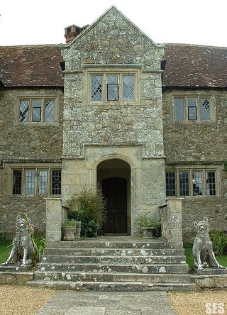
Arreton Manor is a manor house in Arreton, Isle of Wight, England. Its history is traced to 872 AD to the time of King Alfred the Great and his parents. It was left by King Alfred by his will to his youngest son Aethelweard. Once owned by William the Conqueror, as mentioned in the Domesday Book in 1086, in the 12th century it became part of Quarr Abbey and was used by the monks for over 400 years. In 1525, it was leased to the Leigh family. The manor was rebuilt between 1595 and 1612. Built in Jacobean style, it is in the shape of a "H".

The Great Budbridge Manor is a manor house just south of Merstone, near Arreton, Isle of Wight, England. Fish ponds on the grounds appear medieval.
Morton Manor is a manor house originating in the 13th century, in Brading, Isle of Wight, England. It is located 1 mile (1.6 km) southwest of Sandown Road. The fairly small 14th-century house was modified in the 19th century. Constructed of varied materials, it was refurbished and extended in the early 20th century in an Arts and Crafts style. The house has a Tudor fireplace in the dining room, with William De Morgan green glazed tiles, and the manor includes a small museum of rural life.

Nunwell House, also Nunwell Manor, is a historic English country house in Brading, Isle of Wight. Located 3 miles (4.8 km) south of Ryde, the Tudor and Jacobean style house also has later additions. The house contains family militaria. It was occupied by the Oglander family from Norman times. Nunwell House is a Grade II* listed building.
Smallbrook Manor is a manor house on the Isle of Wight, lying at the north-eastern boundary of Newchurch parish. It doubtless took its name from the stream that here forms the boundary of the parish. It is of ancient origin, as in 1280 William de Smallbrook (Smalebrook) granted land to his son Hugh. It was held at the end of the 14th century by the Wyvill family, and remained in their possession until 1491–2, when Stephen Wyvill, the last of the family, sold it to Henry Howles. Smallbrook passed in the Howles family until the reign of Elizabeth, when it was divided between co-heirs and sold to Sir William Oglander. In the court held at Ashey Manor, 1 November 1624, Sir John Oglander was returned as a freeholder and free suitor of the manor for his farm called 'Smallbroke.' The estate has since descended with Nunwell and as of 1912 was held by Mr J. H. Oglander, who had the Court Rolls in his possession.
Merston Manor is a manor house in Merstone on the Isle of Wight, England. The manor was first mentioned in the Domesday Book. Prior to the Norman Conquest, Merston Manor was owned by the Brictuin family. The present home, built in 1605 in the Jacobean style by Edward Cheeke, was rebuilt in the Victorian era. This structure may be the oldest brick house on the Island. The manor now belongs to the Crofts family.
Briddlesford Manor, is a manor house on the Isle of Wight, situated in the parish of Arreton.
Combley Manor is a manor house on the Isle of Wight, situated in the parish of Arreton. It lies in the low ground to the north of Arreton Down, and mostly consists of woodland and pasture. Its first appearance is in a deed between its then owner Simon Fitz Hubert and the convent of Quarr exchanging it for the somewhat insignificant holding of Blackland. It remained in the possession of Quarr Abbey until its dissolution, but does not appear as a manor till quite late in the 15th century; indeed, in the valuation of Quarr Abbey lands in 1536 it is entered as 'a farm called Combley in Atherton parish.' In February 1537 Combley, called a manor, was granted in fee to Thomas Wriothesley, and it subsequently followed the same descent as Haseley.
Hale Manor is a manor house on the Isle of Wight, situated in the parish of Arreton. It forms the south-eastern portion of the parish adjoining Newchurch, and comprises the high ground to the south of the River Yar above Horringford.
Horringford Manor is a manor house on the Isle of Wight, situated in the parish of Arreton.
Huffingford Manor is a manor house on the Isle of Wight, situated in the parish of Arreton.
Rookley Manor is a manor house in the parish of Arreton, Isle of Wight, England. Though originally in Godshill parish, it is now included for the greater part in the boundaries of South Arreton.
Barnsley Manor is a manor house in the parish of Brading on the Isle of Wight.
Grove Manor is a manor house in the parish of Brading on the Isle of Wight in England.
Hardingshute Manor is a manor house in the parish of Brading on the Isle of Wight.
Rowborough Manor is a manor house in the parish of Brading on the Isle of Wight.
Redway Manor is a manor house on the Isle of Wight, situated in the parish of Arreton.

Avon Tyrrell is an historic manor within the parish of Sopley, Hampshire. It is situated within the New Forest, near Christchurch. The present manor house was built in 1891 by John Manners-Sutton, 3rd Baron Manners (1852–1927).
