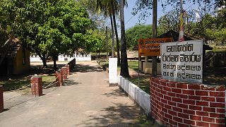
History and archeology
The Temple complex is considered to have been built by King Devanampiyatissa (307–267 BC) and one of the oldest Buddhist temple complexes in the country. Later for various reasons this complex was forgotten and by the time of king Sirisangabo this was covered with jungle.
Siri Sangha Bodhi I was King of Anuradhapura in the 3rd century, whose reign lasted from 252 to 254. He succeeded Sangha Tissa I as King of Anuradhapura and was succeeded by Gothabhaya.
It has been taken into consideration that this was the location where King Sirisangabo (251–253 AD) offered his own head to a peasant. Previously it was widely considered that this incident took place at Attanagalla in Gampaha district now most scholars have raised the argument that this must be the place that it really took place.
Attanagalla is an electorate in Gampaha District, situated in the Western Province of Sri Lanka.

Gampaha is an urban city in Gampaha District, Western Province, Sri Lanka. It is situated to the north-east of the capital Colombo. It is the sixth largest urban area in Western Province, after Colombo, Negombo, Kalutara, Panadura and Avissawella. Gampaha is also the second largest municipal centre in Gampaha district, after Negombo. Gampaha has a land area of 25.8 ha and is home to the offices of 75 government institutions.
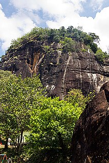
Main reason for this idea was that, in the story it says the peasant walked half a day from Anuradhapura towards the south where he met the former king Sirisangabo. Since 'Hatthikuchchi Viharaya' is only 38.5 km from Anuradhapura rather than Attanagalla which is 170 km from Anuradhapura there is a better chance this is the actual place the incident took place.
Anuradhapura is a major city in Sri Lanka. It is the capital city of North Central Province, Sri Lanka and the capital of Anuradhapura District. Anuradhapura is one of the ancient capitals of Sri Lanka, famous for its well-preserved ruins of an ancient Sri Lankan civilization. It was the third capital of the kingdom of Rajarata, following the kingdoms of Tambapanni and Upatissa Nuwara.
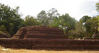
Supporting this facts there is a tomb which is considered to have the ashes of the king Sirisangabo. In this tomb the tombstone which is built from bricks resembling a human body have a granite sphere as the head piece since it was missing in the dead body.
Excavations are still under way at the site and more ruins are yet to be found which are covered with the jungle.

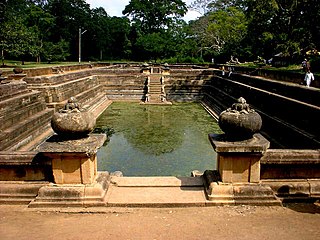
Isurumuniya is a Buddhist temple situated near to the Tissa Wewa in Anuradhapura, Sri Lanka. There are four carvings of special interest in this Vihara. They are the Isurumuniya Lovers, Elephant Pond and The Royal Family.
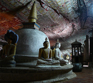
Dambulla cave temple also known as the Golden Temple of Dambulla is a World Heritage Site (1991) in Sri Lanka, situated in the central part of the country. This site is situated 148 kilometres (92 mi) east of Colombo and 72 kilometres (45 mi) north of Kandy.

Dimbulagala Raja Maha Vihara is situated 16 kilometres south east of the ancient city of Polonnaruwa, Sri Lanka. The Dimbulagala range houses a number of caves cut into the rock with Brahmi inscriptions over their drip ledges. This forest hermitage of medieval times and holy abode since time immemorial, home to some of the most valued fragments of early frescoes was called the Gunners Quoin by the British. This Buddhist monastery which was abandoned after the times of the Kingdom of Polonnaruwa was restored to the present status in the 1950s due to the efforts of Kithalagama Sri Seelalankara Thera, who was the chief incumbent of the Vihara until his death in 1995.

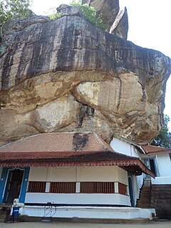
The Aluvihare Rock Temple is a sacred Buddhist temple located in Aluvihare, Matale District of Sri Lanka. Surrounded by hills, the Aluvihara cave temple is situated 30 km north of Kandy on the Matale-Dambulla road. The history of Aluvihare Rock Temple is traced back to the 3rd Century B.C to the reign of King Devanampiyatissa. It is believed that the King built the dagoba, planted the Bo sapling and founded the temple after the introduction of Buddhism to the country during his reign.
Ridi Viharaya or Silver Temple is a 2nd-century BCE Theravada Buddhist temple in the village of Ridigama, Sri Lanka. Built during the reign of Dutthagamani of Anuradhapura, the temple is considered as the place where the silver ore, which provided silver to complete Ruwanwelisaya; one of the largest stupa in Sri Lanka, was discovered. According to the chronicles Mahavamsa and Thupavamsa, the Ridi Viharaya complex was built in gratitude for helping him cherish his dream of completing Ruwanwelisaya.
Gokanna Viharaya was an ancient Buddhist temple located in Trincomalee in the Eastern Province of Sri Lanka. The temple lies in the premises of Fort Fredrick close to the fort entrance.
Mulkirigala Raja Maha Vihara is an ancient Buddhist temple in Mulkirigala, Sri Lanka. It has been built on a 205 m (673 ft) high natural rock, surrounded with another four rocks known as Benagala, Kondagala, Bisogala and Seelawathiegala. The temple site is located about 2 km (1.2 mi) from the Mulkirigala junction and can be reached from either Dikwella or Tangalle towns. The temple has been formally recognised by the Government as an archaeological site in Sri Lanka. The designation was declared on 8 April 1988 under the government Gazette number 501.

Magul Maha Viharaya is an ancient Buddhist temple situated in Lahugala, Ampara District of Sri Lanka. The temple lies on the northern edge of the Lahugala National Park, about 22 km off from Siyambalanduwa town and about 11 km off Pottuvil town. Lahugala has been part of the Kingdom of Ruhuna in ancient Sri Lanka. The ruins of Magul Maha Vihara are one of the major tourist attractions of the
Eastern province. This temple is also an archaeologically protected monument of the country.

Naigala Rajamaha Viharaya is an ancient Buddhist temple situated in Weeraketiya, Hambantota District, Sri Lanka. It is located about 2 km (1.2 mi) away from Weeraketiya junction and 8 km (5.0 mi) from ancient Buddhist temple, Mulkirigala Raja Maha Vihara.

Lankatilaka Vihara is an ancient Buddhist temple situated in Udunuwara of Kandy, Sri Lanka. It is located on Daulagala road approximately 4 km (2.5 mi) away from Pilimatalawa junction and a few kilometres from the ancient buddhist temple, Gadaladeniya Vihara. It is considered as the most magnificent architectural edifice created during the Gampola era.

Kadurugoda Viharaya is an ancient Buddhist temple situated in Chunnakam, Jaffna District, Sri Lanka. The temple is located in a small hamlet called Kandarodai and it is one of the few Buddhist temples remaining in Jaffna today. Currently this temple has been declared as an archaeological site in Sri Lanka and is maintained by the Sri Lankan army.
Velgam Vehera is a historical Buddhist temple situated in Kanniya, Trincomalee District, Sri Lanka. It also known to Hindus as Natanar Kovil. Historically Velgam Vehera was one of important Buddhist temples in the country, worshiped by both Sinhala and Tamil Buddhists.

Maligatenna Raja Maha Vihara is an ancient Cave temple which is located in Malwatuhiripitiya village, Gampaha District, Sri Lanka. The temple is located on the Gampaha - Wathurugama Road and approximately 1.6 km (0.99 mi) away from the ancient temple Pilikuththuwa Raja Maha Vihara.

Pilikuththuwa Raja Maha Vihara is an ancient Cave temple situated in Pilikuththuwa, Sri Lanka. It is located on the Gampaha - Wathurugama road approximately 3.8 km (2.4 mi) away from the Miriswatta junction and 1.6 km (0.99 mi) from the ancient Buddhist temple, Maligatenna Raja Maha Vihara. The temple has been formally recognised by the Government as an archaeological site in Sri Lanka.

Gadaladenyia Vihara is an ancient Buddhist temple situated in Pilimathalawa, Kandy, Sri Lanka. It is located on Gadaladenyia Road (B116), just up from the Gadaladeniya junction of the Colombo - Kandy Road (A1), approximately 12.5 km (7.8 mi) to the west of Kandy and 3 km (1.9 mi) from the ancient buddhist temple, Lankatilaka Vihara. It is considered one of the largest rock temples in Sri Lanka.

Kasagala Raja Maha Vihara is an ancient Buddhist Temple, situated in Angunukolapelessa, Hambantota District, Sri Lanka. It is situated about 10 km (6.2 mi) away from Ranna Junction along Ranna - Weeraketiya road. The temple has been formally recognised by the Government as an archaeological site in Sri Lanka. The designation was declared on 6 June 2008 under the government Gazette number 1553.
Lahugala is a small town in Ampara District, Eastern Province of Sri Lanka. The town is located on Colombo-Batticaloa main road approximately 14 km (8.7 mi) away from Pothuvil town.
Buddama Raja Maha Vihara is a historic Cave temple in Buddama village, Monaragala district, Sri Lanka. Buddama is a rural village lying off Siyambalanduwa town and known as one of early settlements in the country. Currently the temple has been formally recognised by the Government as an archaeological site in Sri Lanka.

Aramanapola Raja Maha Vihara or Ganegama Rankoth Vihara is an ancient Buddhist temple in Ganegama, Sri Lanka. The Vihara is located approximately 2.5 km (1.6 mi) far away from the Pelmadulla town on Colombo - Batticaloa main road (A4). The temple has been formally recognised by the Government as an archaeological site in Sri Lanka. The designation was declared on 2 March 1951 under the government Gazette number 10217.

Keheliya Raja Maha Vihara is an ancient Buddhist temple in Monaragala District, Sri Lanka. The temple is located in Handapanagala village approximately 11 km (6.8 mi) distance from Wellawaya town. The temple has been formally recognised by the Government as an archaeological site in Sri Lanka. The designation was declared on 22 November 2002 under the government Gazette number 1264.