
The Ahaura River is in the South Island of New Zealand. This river drains the western flanks of the Southern Alps and flows into the Grey River.

The Waimakariri River is one of the largest rivers in Canterbury, on the eastern coast of New Zealand's South Island. It flows for 151 kilometres (94 mi) in a generally southeastward direction from the Southern Alps across the Canterbury Plains to the Pacific Ocean.

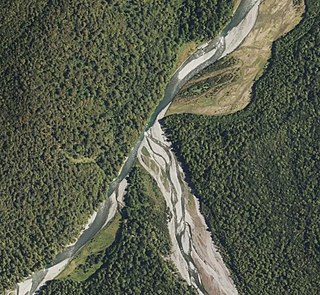
Crooked River is a river that flows from headwaters in the Southern Alps to Lake Brunner in the West Coast region of New Zealand's South Island. It is named for the erratic path it takes. Near Lake Brunner, it passes through reasonably flat farmland, but closer to its source, it rushes through gorges and rapids. One tributary is the Poerua River from Lake Poerua.

The Mohaka river is on the North Island of New Zealand in the east central region of Hawke’s Bay. Mohaka is a Maori word, roughly translated it means “place for dancing”. The iwi associated with the Mohaka River are Ngāti Pāhauwera, Ngāti Hineuru, Ngāti Tūwharetoa and Mana Ahuriri. The headwaters are found in the Kaweka and Kaimanawa ranges. From the range it winds southeast before twisting northeast and finally southeast again to empty into the Pacific Ocean near the town of Mohaka. There are many gorges on the Mohaka; some as steep as 200m. Its main tributaries are the Waipunga, Taharua, Hautapu rivers. The full length is 172 kilometres (107 mi) and it drains a basin of 2,357 square kilometres (910 sq mi).
Haupiri is a locality in the West Coast region of New Zealand's South Island. Greymouth lies to the west. The Ahaura and Haupiri Rivers run through the area.

The Cust River is a river in the Canterbury region of New Zealand. It flows east across the upper Canterbury Plains from its source north of the town of Oxford, New Zealand, flowing into the Cam River / Ruataniwha close to the town of Rangiora. The small town of Cust lies on the banks of the river. The lower part of the river, to the south-west of Rangiora, is diverted into a channel and called the "Main Drain". The channel was built in 1862 to drain the swampy land between Rangiora and the Waimakariri River, and when it was enlarged in 1868 it accidentally captured the Cust.

The Doubtful River is a river in the Canterbury region of New Zealand. It rises near Mount Barron and flows south then south-east through Lake Sumner Forest Park, reaching the Boyle River 40 kilometres (25 mi) west of Hanmer Springs. The Doubtful Range lies to the south. The Doubtless River and Devilskin Stream are tributaries entering from the north.
The Evans River is a short river in New Zealand's South Island. It arises near Mount O'Shanessy in the Kaimata Range of the Southern Alps and flows north-west and then south-west, joining the Crooked River several kilometres before the latter's outflow into Lake Brunner.
The Goulter River is a river in the Marlborough region of New Zealand. It rises in the Richmond Range near Lake Chalice. The lake was formed by a landslip about 2000 years ago, which dammed the river. The lake has no outlet, but water seeps through the landslip rubble into the Goulter. The river flows counter-clockwise around Mount Patriarch to join the Wairau River.
The Hangaroa River is a river in the Gisborne Region of New Zealand. Its source is the Huiarau Ranges in the Te Urewera National Park, and flows southeast to merge with the Ruakituri River near Te Reinga. The combined rivers form the Wairoa River, which flows south into Hawke Bay.
The Hapuka River is a river of Westland District, New Zealand. It flows from near The Woolsack north-west to join the Okuru and Turnbull Rivers just before they enter the Tasman Sea. The river is slow-moving and drains swampy land. There are brown trout in the lagoon area.

The Harman River is a river of New Zealand. It starts in the Browning Range of the Southern Alps and becomes the Arahura River, which flows into the Tasman Sea north of Hokitika.
The Nancy River is a river of the West Coast Region of New Zealand's South Island. A tributary of the Ahaura River, it flows generally southwest from its source to the west of Mount Hochstsetter in the Southern Alps, turning west shortly before its outflow, 15 kilometres southeast of Lake Hochstetter.
The Trent River is a river of the West Coast Region of New Zealand's South Island. It flows east from its source in the Kaimata Range northeast of Otira, turning north to reach the valley of the Ahaura River via the Tūtaekurī River.

The Waiheke River is a river of the West Coast Region of New Zealand's South Island. It flows west from its origins on Mount Barron in the Southern Alps to reach the Ahaura River, which it forms where it joins the Tūtaekurī River, 20 kilometres northwest of Lake Sumner.
The Waikiti River is a river of the West Coast Region of New Zealand's South Island. It flows generally north from it sources in the eastern Kaimata Range, roughly paralleling the course of its larger eastern neighbour, the Trent River. It reaches the Ahaura River 20 kilometres southeast of Lake Hochstetter.
Canterbury's Esk River is a tributary of the Waimakariri River. It rises in the Dampier Range near Esk Head, and flows southwest on the western side of the Puketeraki Range to reach the upper Waimakariri some 20 kilometres (12 mi) north of Springfield.
The Dove River is a river in the Tasman Region of New Zealand. It arises in hills between the Wai-iti River and Motueka River and flows north-west into the Motueka near the locality of Woodstock. The river is named for the native New Zealand pigeons once found in the forests around the river.
The Gelt River is a river in the Canterbury region of New Zealand. It arises near Mount Peter in the Black Hills and flows south, then east and north-east into Conway River.
The Tūtaekurī River starts near the Hope Pass, in the Southern Alps and flows north-west to join the Ahaura River. The Ahaura joins the Grey River which flows to the Tasman Sea at Greymouth. Tūtaekurī River has been its official name since 21 June 2019. Tūtae kurī is a grass with the latin name agropyron multiflorum.
