
Edgeøya, occasionally anglicised as Edge Island, is a Norwegian island located in southeast of the Svalbard archipelago; with an area of 5,073 square kilometres (1,960 sq mi), it is the third largest island in this archipelago. An Arctic island, it forms part of the Søraust-Svalbard Nature Reserve, home to polar bears and reindeer. Its eastern side is covered by an ice field. The island is named after Thomas Edge, an English merchant and whaler. It is seldom visited today.

Danes Island is an island in Norway's Svalbard archipelago in the Arctic Ocean. It lies just off the northwest coast of Spitsbergen, the largest island in the archipelago, near to Magdalenefjorden. Just to the north lies Amsterdam Island. Like many of Svalbard's islands, Danes Island is uninhabited. The island has an area of 40.6 km2 (15.7 sq mi).
Van Mijenfjorden is the third-longest fjord in Norway's Svalbard archipelago. It lies in the southern portion of Spitsbergen island, south of Nordenskiöld Land and north of Nathorst Land. The fjord is 83 km (52 mi) long, being separated from Bellsund further out by Akseløya and Mariaholmen. The settlement of Sveagruva lies on the fjord's north bank.

Wahlenbergfjorden, sometimes known in English as Waalenburg Bay, is a fjord on the southwest coast of the Arctic island of Nordaustlandet, in Norway's Svalbard archipelago. At 46 kilometres (29 mi) in length, and 15 km (9.3 mi) wide, it is the fifth longest fjord in the archipelago, and the longest on the island. The fjord lies between Gustav V Land and Gustav Adolf Land, at geographical co-ordinates 79°40′N20°00′E. Its mouth faces Spitsbergen across Hinlopen Strait, the strait separating the two islands.
Bellsund is a 20-kilometer (12 mi) long sound on the west coast of Spitsbergen, part of the Svalbard archipelago of Norway. It is separated from Van Mijenfjorden by the islands of Akseløya and Mariaholmen. Bellsund is located south of Nordenskiöld Land and north of Wedel Jarlsberg Land.
Akseløya is a long, narrow island at the mouth of Van Mijenfjorden, separating Van Mijenfjorden from Bellsund. It is separated from the mainland by Akselsundet to the north, and another narrow strait to the south. The islands are named after the schooner Aksel Thordsen, which was chartered by Adolf Erik Nordenskiöld for an expedition to Svalbard in 1864.
Eholmen is a 1.5 km long island in the divide between Bellsund and Van Keulenfjorden, on the west coast of Spitsbergen. It is the southwesternmost point of Nathorst Land.
Adventfjorden is a 7 km long and 4 km wide bay on the southern side of Isfjorden, on the west coast of Spitsbergen. The name is a corruption of Adventure Bay, which was probably named after the Hull whaleship Adventure, which resorted to Isfjorden in 1656. The fjord was originally known as Klass Billen Bay. At the head of Adventfjorden is Adventdalen.
Ekmanfjorden is an 18 km (11 mi) long fjord branching north from inner Isfjorden. It is separated by Nordfjorden to the south by Sveaneset in the west and Kapp Wærn in the east. It lies within Nordre Isfjorden National Park.
Ryke Yseøyane is a group of several small islands off the east coast of the island of Edgeøya in Svalbard, Norway. The islands are named after the Dutch whaler Ryke Yse of Vlieland, who discovered them about 1640–1645. The group was first marked by Hendrick Doncker, of Amsterdam, in 1663. Two Norwegian polar bear hunters wintered on Ryke Yseøyane for two subsequent winters in 1967–1969. During the second winter, one of them was lost in drifting ice.
Bölscheøya is an island southwest of Negerpynten, the southeastern point of Edgeøya. It is part of Thousand Islands. The island was named in 1868 by the German geographer August Petermann (1822–78) after the German journalist Carl Bölsche, father of the German writer and zoologist Wilhelm Bölsche (1843–93). The remains of a whaling station from the 17th century can be found on the island.
Brækmoholmane is an island group composed of three islands, Store Brækmoholmen, Trønderen and Alkekongen. They form part of Thousand Islands, an archipelago south of Edgeøya. The islands are named after the Norwegian sailor and fisherman Sivert Brækmo (1853-1930), who visited Svalbard regularly between 1876 and 1895.
Tareloppa is an islet 2 miles northeast of Brækmoholmane, part of Thousand Islands, an archipelago south of Edgeøya.
Oscar II Land is the land area between Isfjorden and Kongsfjorden on Spitsbergen, Svalbard. The 30 km (19 mi) long glacier Sveabreen divides Oscar II Land from James I Land.
Wedel Jarlsberg Land is the land area between Van Keulenfjorden and Hornsund on the southwestern part of Spitsbergen, Svalbard. The area is largely covered with glaciers, and is completely within the Sør-Spitsbergen National Park.
Nathorst Land is the land area between Van Keulenfjorden and Van Mijenfjorden on Spitsbergen, Svalbard.

Kongsfjorden Bird Sanctuary is a 140 ha bird reserve at Svalbard, Norway, established in 1973. It includes islands and islets in Kongsfjorden, Haakon VII Land. It lies at the inner end of the fjord and consists of about ten islands, mainly covered with grassy vegetation and having small freshwater ponds. The fjord is surrounded by steep mountains, cliffs, glaciers and tundra. The reserve has been recognised as a wetland of international importance by designation under the Ramsar Convention. It has also been identified as an Important Bird Area (IBA) by BirdLife International. It supports breeding populations of pink-footed and barnacle geese, common and king eiders, long-tailed ducks, purple sandpipers, red phalaropes, glaucous gulls, long-tailed jaegers and snow buntings. Ivory gulls have been recorded.
Duvefjorden is a fjord at the northern side of Nordaustlandet, Svalbard. The fjord has a length of about 35 kilometres (22 mi) and a width of 12 to 13 km. Former names of the fjord include Baye du Pigeon, Dove Bay, Tauben Bai and Duiven-baai.
Systemafjellet is a mountain in Nordenskiöld Land at Spitsbergen, Svalbard. It is named after the work Systema Naturae by Carl Linnaeus. The mountain has a length of about three kilometers, and peaks of 745 and 667 m.a.s.l. It is located between the valley of Orustdalen and the mountain ridge of Linnéfjella. The glacier of Linnébreen flows from Systemafjellet down towards Linnédalen.
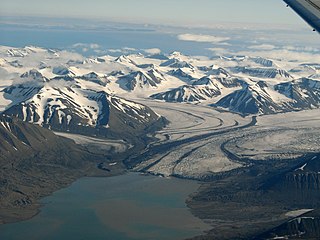
Paulabreen is a glacier in Nathorst Land and Heer Land at Spitsbergen, Svalbard. It has a length of about fifteen kilometers, extending from the mountain of Kjølberget to the bay of Rindersbukta. The glacier is named after Paula, the wife of shipmaster Richard Ritter von Barry. Paulabreen borders to the mountain area of Vriompeisen, and the mountain of Hollertoppen. A tributary glacier is Bakaninbreen.


