West Saint Paul is a city in Dakota County, Minnesota, immediately south of Saint Paul, Minnesota, and immediately west of South Saint Paul, Minnesota, United States.

The Barossa Valley is a valley in South Australia located 60 kilometres (37 mi) northeast of Adelaide city centre. The valley is formed by the North Para River. The Barossa Valley Way is the main road through the valley, connecting the main towns on the valley floor of Nuriootpa, Tanunda, Rowland Flat and Lyndoch. The Barossa Valley is notable as a major wine-producing region and tourist destination.
The Metropolitan Borough of Dudley is a metropolitan borough of West Midlands in England. It was created in 1974 following the Local Government Act 1972, through a merger of the existing Dudley County Borough with the municipal boroughs of Stourbridge and Halesowen. The borough borders Sandwell to the east, the city of Birmingham to the south east, Bromsgrove to the south in Worcestershire, South Staffordshire District to the west, and the city of Wolverhampton to the north.
Hanham is a suburb of Bristol. It is located in the south east of the city. Hanham is in the unitary authority of South Gloucestershire. It became a civil parish on 1 April 2003.
Harrow is a large suburban town in the London Borough of Harrow, in the north-west of Greater London, England, 10.5 miles (16.9 km) north-west of Charing Cross. Harrow-on-the-Hill is a conservation area with listed buildings of Georgian architecture. The area, which also includes Headstone North, Roxeth, Marlborough, Greenhill, Headstone South and West Harrow electoral wards, had a population of 80,213 at the 2011 census. Harrow was a municipal borough of Middlesex before its inclusion in Greater London in 1965. Harrow is home to a large University of Westminster campus, Harrow School and Harrow High School.

South Bruce Peninsula is a town at the base of the Bruce Peninsula of Ontario, Canada, in Bruce County between Lake Huron and Georgian Bay. It was formed on January 1, 1999, when the town of Wiarton, the village of Hepworth, and the townships of Albemarle and Amabel were amalgamated. This new municipality was created to provide necessary political representation, administrative support and necessary municipal services on behalf of the residents.

Kincardine is a municipality located on the shores of Lake Huron in Bruce County in the province of Ontario, Canada. The current municipality was created in 1999 by the amalgamation of the Town of Kincardine, the Township of Kincardine, and the Township of Bruce.

Farnworth is a town and an unparished area within the Metropolitan Borough of Bolton in Greater Manchester, England. It is located 2.3 miles (3.7 km) southeast of Bolton, 4.3 miles south-west of Bury (7 km), and 7.5 miles (12.1 km) northwest of Manchester.

The Evangelical Lutheran Church in Tanzania (ELCT) is the federation of Lutheran churches in Tanzania and one of the largest Lutheran denomination in the world with more than 6 million members.

The City of Willoughby is a local government area on the Lower North Shore of Sydney, in the state of New South Wales, Australia. It is located 6 kilometres (3.7 mi) north of the Sydney central business district. It was first proclaimed in October 1865 as the Municipality of North Willoughby.

Walkergate is an area and electoral ward in the city of Newcastle upon Tyne in Tyne and Wear, England. It is in the east of the city, north of Walker proper, east of the Heaton area and west of Wallsend. Areas within the Walkergate ward include Daisy Hill, Eastfield, Walkerdene and Walkerville. Walkergate Metro station which was opened in 1982 serves the area. This replaced the previous railway station on the same site which was originally known as Walker station from 1839 to 1889 when it was renamed Walker Gate station.

Kahama Urban District is one of the five districts of the Shinyanga Region of Tanzania. Its administrative centre is the town of Kahama. It is bordered to the north and south by Kahama Rural District, to the east by Nzega District and to the west by Bukombe District.

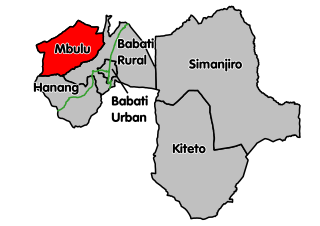
Hanang District is one of the six districts of the Manyara Region of Tanzania. It is bordered to the North by the Mbulu District and Babati Rural District, to the Southeast by the Dodoma Region and to the Southwest by the Singida Region. Mount Hanang is located within the boundaries of the district.

Bomet is the capital and largest town of Bomet County. Bomet town has a total population of 110,963. It is located along the B3 Mai Mahiu-Narok-Kisii road.
Onandjokwe State Hospital, until 2016 Onandjokwe Lutheran Hospital, is the oldest hospital in the northern part of Namibia. It was built in 1911 by the Finnish Missionary Society under the leadership of Selma Rainio. The hospital was operated by the Evangelical Lutheran Church in Namibia (ELCIN) via Lutheran Medical Services until 2016, when the Government of Namibia took over.

Llandrindod East/Llandrindod West is the name of an electoral ward in the town of Llandrindod Wells, Powys, Wales.