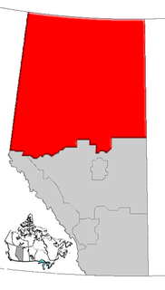
Grande Prairie-Wapiti is provincial electoral district in northwestern Alberta, Canada. It is one of 87 mandated to return a single member to the Legislative Assembly of Alberta using the first past the post method of voting.

Hythe is a village surrounded by the County of Grande Prairie No. 1 in northwestern Alberta, Canada. It is located on Highway 43 approximately 58 km (36 mi) northwest of the City of Grande Prairie and 73 km (45 mi) southeast of the City of Dawson Creek, British Columbia.
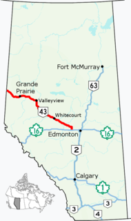
Alberta Provincial Highway No. 43, commonly referred to as Highway 43, is a major highway in northern and central Alberta, Canada that connects Edmonton to the British Columbia border via the Peace Country, forming the northernmost portion of the CANAMEX Corridor in Alberta. It stretches approximately 499 km (310 mi) from Highway 16 near Carvel west of Edmonton to the British Columbia border west of Demmitt. It is designated as a core route in Canada's National Highway System, comprising a portion of a key international corridor that stretches from Alaska into Mexico.
Clairmont is a hamlet in northern Alberta, Canada within the County of Grande Prairie No. 1. Previously an incorporated municipality, Clairmont dissolved from village status on January 1, 1946 to become part of the Municipal District of Bear Lake No. 740.
Elmworth is a hamlet in northern Alberta, Canada within the County of Grande Prairie No. 1. It is located on Highway 722 north of the Wapiti River and east of the British Columbia border. It has an elevation of 715 metres (2,346 ft). The Elmworth natural gas field stretches west and south of the hamlet.
Albright, Alberta is an unincorporated locality within northwest Alberta, Canada within the County of Grande Prairie No. 1. It is located on Highway 43 and the Grande Prairie-Grande Cache Railway between Beaverlodge and Hythe. It has an elevation 740 meters (2,430 ft).
Goodfare is a hamlet in northern Alberta, Canada within the County of Grande Prairie No. 1. It is located on Highway 671, approximately 14 kilometres (8.7 mi) west of Highway 43 and 60 kilometres (37 mi) northwest of Grande Prairie.
Rio Grande is an unincorporated community in northern Alberta within the County of Grande Prairie No. 1, located 32 kilometres (20 mi) southwest of Highway 43, 65 kilometres (40 mi) west of Grande Prairie.
Sylvester is an unincorporated community in northern Alberta within the County of Grande Prairie No. 1, located 41 kilometres (25 mi) southwest of Highway 43, 75 kilometres (47 mi) west of Grande Prairie.
The locality of Halcourt, about 40 km west of Grande Prairie, was named after Harry Halcourt Walker, an early settler who filed claim in April 1910 as the land was being surveyed for settlement. The first public building was the Halcourt Methodist Church, which opened in 1911. In 1912, Halcourt School District 2835 was formed and classes held in the church until a log school was built kitty-corner from the church in 1914. On May 15, 1913, a post office was established in Thomas Metcalf’s home across the road east of the school on Section 33, township 70, range 10, west of the 6th meridian. This was the center of the community until 1917, when the school was moved two miles west to the intersection of ranges 10 and 11, and townships 70 and 71. This was where the community grew, with the addition of Funnell’s Store, the District Nurse’s Cottage, and Frank Keasis’ blacksmith shop in 1922. About the same time, a cemetery was laid out a half mile south of the church. In 1924, the Orangemen’s Hall was built across the road from the school, and in 1938 a Curling Rink beside the hall. During the 1930s the residents created a Sports Ground two miles south on the banks of the Red Willow River. The community also boasted a tennis court, a Literary Society, and Funnell’s Orchestra. After 45 years of operation, the school closed in 1957, but the building was retained as a hall operated by the Halcourt Ladies Club. The post office closed in 1962. (4) Today, the historic church and school, as well as the active cemetery mark the locality of Halcourt.
The locality of Hayfield was also known as Leighmore, approximately 52 km west of Grande Prairie, formed around the Leighmore Post Office established July 1, 1922 in the home of George James Beadle on the SW quarter of section 10, township 71, range 11, west of the 6th meridian. According to Place Names of Alberta. Volume IV. Northern Alberta, it was named after post master Beadle’s former home in the Channel Islands, the Barnardo Boys Home at Teighmore Park on the Island of Jersey. The name was misspelled, and recorded as Leighmore. In 1934, Hayfield School District 4661 was formed for the children of the area, as their former schools at Appleton and Rio Grande were becoming overcrowded. The post office closed in 1947, and the school in 1950. Information on people who lived in the Leighmore district can be found in Beaverlodge to the Rockies.
The locality of Hinton Trail, about 40 km south-west of Grande Prairie, developed at the north end of the Hinton Trail which ran from Jasper to Hinton, and then on to "the grande prairie". From Hinton, the trail followed Nose Creek north up to the Wapiti River, crossing it and heading overland to the Redwillow River about a half mile west of where the first Hinton Trail Post Office was set up in the home of Stan Ronksley on the NW quarter of section 5, township 70, range 10, west of the 6th meridian. The Ronksley home was across from Craigellachie School, a one-room log school built in 1922. The school also served as the community gathering place until the Hinton Trail Hall was built in 1947. The school closed in 1948, and the post office in 1968. The Hinton Trail Hall and a marker showing where the Hinton Trail crossed through the area about ½ mile east of the hall still mark this locality. Information on the people who lived in the Hinton Trail district can be found in Beaverlodge to the Rockies and its Supplement.
The locality of Mount Valley, approximately 54 km south-west of Grande Prairie, centered on the Mount Valley Store which was established by Colonel Lyle and Cephas Tennyson of Beaverlodge ca. 1930. The name is descriptive, as the location of the store was in a valley near the mountains. It was located on Ed Moore’s homestead, the NE quarter of section 25, township 70, range 13, west of the 6th meridian. In January 1932, West End School District 4592 was organized and a log school on a stone foundation was built two miles west of the store on the NW quarter of section 23. On January 8, 1938, the Mount Valley Post Office was added to the store, now owned by the Elliott family. The postmistress was Mrs. Elva Elliott Lingrell, a daughter of the family. Although the school only lasted a few years, closing in 1935, the store and post office operated until the building burned down in 1951. The closing date for the post office is recorded as September 16, 1951.

Glen Leslie, Alberta is an unincorporated locality in northwest Alberta, Canada within the County of Grande Prairie No. 1. It is approximately 20 km (12 mi) east of Grande Prairie, south of Highway 43 on Highway 670.

Buffalo Lake is an unincorporated locality in northwest Alberta, Canada within the County of Grande Prairie No. 1. It is located approximately 22 km (14 mi) northwest of Grande Prairie. The locality is on Highway 59 within proximity of Buffalo Lake for which it is named. Buffalo Lake is one of a group of lakes referred to as Buffalo Lakes. Bison were known to use the lakes as a watering hole and to wallow in the shallow waters as a respite from heat and insects. Many buffalo skulls were found in the area by early settlers.
Brainard is an unincorporated locality in northwest Alberta within the County of Grande Prairie No. 1. It is located approximately 61 kilometers (38 mi) north-west of Grande Prairie, Alberta. The locality was originally established in 1919 and took the name of the first postmaster, Lee Brainard.
Bad Heart, Alberta, Canada is a small town in the County of Grande Prairie No. 1, approximately 50 km north-east of the town of Grande Prairie, Alberta.
Fitzsimmons is an unincorporated locality in northwest Alberta within the County of Grande Prairie No. 1. It is located approximately 30 km north-east of the City of Grande Prairie.

The locality of Webster, Alberta was established in 1916 as a station on the Edmonton, Dunvegan and British Columbia Railway, about 30 km north of the city of Grande Prairie. It was named after George Webster, a subcontractor for the railway at that time.

Euphemia "Betty" McNaught was a Canadian impressionist painter who focused primarily on landscapes and pioneer lifestyles in Alberta. She was the founding member of the Grande Prairie Art Club and the Beaverlodge Art Club. McNaught was born in Glen Morris, Ontario, in 1902, and died at the age of 100 in Beaverlodge, Alberta.