Related Research Articles
Alexandria is the ninth-largest city in the state of Louisiana and is the parish seat of Rapides Parish, Louisiana, United States. It lies on the south bank of the Red River in almost the exact geographic center of the state. It is the principal city of the Alexandria metropolitan area which encompasses all of Rapides and Grant parishes. Its neighboring city is Pineville. In 2010, the population was 47,723, an increase of 3 percent from the 2000 census.
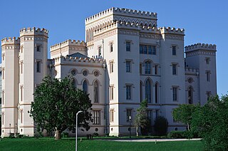
Baton Rouge is the capital city of the U.S. state of Louisiana. Located on the eastern bank of the Mississippi River, it had a population of 227,470 as of 2020; it is the seat of Louisiana's most populous parish (county-equivalent), East Baton Rouge Parish, and the center of Louisiana's second-largest metropolitan area and city, Greater Baton Rouge.
Winn Parish is a parish located in the U.S. state of Louisiana. As of the 2020 census, the population was 13,755. The parish seat and largest city is Winnfield. The parish was founded in 1852. It is last in alphabetical order of Louisiana's sixty-four parishes. Winn is separated from Natchitoches Parish along U.S. Highway 71 by Saline Bayou, the first blackwater protected waterway in the American South.

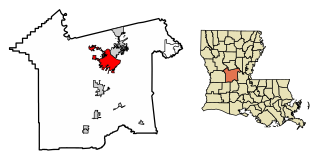
Rapides Parish is a parish located in the U.S. state of Louisiana. As of the 2020 census, the population was 130,023. The parish seat is Alexandria, which developed along the Red River of the South. Rapides is the French word for "rapids". The parish was created in 1807 after the United States acquired this territory in the Louisiana Purchase.

Caldwell Parish is a parish located in the U.S. state of Louisiana. As of 2020, its population was 9,645. The parish seat is Columbia.

Dry Prong is a village in central Grant Parish, Louisiana, United States. It is part of the Alexandria, Louisiana Metropolitan Statistical Area. The population was 436 at the 2010 census.
Georgetown is a village in Grant Parish, Louisiana, United States. It is part of the Alexandria, Louisiana Metropolitan Statistical Area. The population was 327 at the 2010 census.
Pollock is a small town in Grant Parish, Louisiana, United States. It is part of the Alexandria, Louisiana Metropolitan Statistical Area. The population was 469 as of the 2010 census, up from 376 in 2000. Pollock and southern Grant Parish have been experiencing residential and business growth in recent years. The population of Pollock increased between the 2000 and 2010 censuses as a result of the annexation of the land surrounding a federal prison, the United States Penitentiary, Pollock.

Lon Morris College (LMC) was a private junior college located in Jacksonville, Texas, United States, and was the only school affiliated with the United Methodist Church that was owned by an individual conference and not the denomination as a whole. Lon Morris was an accredited two-year institute of higher learning, which provided instruction in the arts and sciences with a core curriculum emphasizing liberal arts. While Lon Morris taught as many as 350 students in a semester, enrollment reached more than 1,000, a new record, in the fall of 2009. The school was 30 miles (48 km) south of Tyler. The person who last held the title of college president was Dr. Miles McCall; he resigned effective May 24, 2012.
Louisiana National Guard Training Center Pineville is a Louisiana National Guard installation located northeast of Pineville, Louisiana, primarily in Rapides Parish, but also extending northward into Grant Parish. It is operated and owned by the Louisiana National Guard as one of their main training areas.

Louisiana Christian University (LC) is a private Baptist university in Pineville, Louisiana. It enrolls 1,100 to 1,200 students. It is affiliated with the Louisiana Baptist Convention.
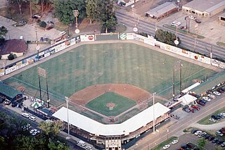
Bringhurst Field was from 1933 to 2013 a baseball stadium in Alexandria, Louisiana. Owned by the city of Alexandria, it served as the home field of the Alexandria Aces, one of the most successful independent league baseball teams, which won various championships in 1997, 1998, 2006, 2007, and 2009. It also hosted local high school games. Built in 1933 and renovated extensively in 1994, it held 3,500 people. It was the home field for a local high school, the Bolton High School Bears.
Libuse is an unincorporated community in Rapides Parish, Louisiana United States and part of the Alexandria metropolitan area, Louisiana. It was founded in 1914 by Czech immigrants, and named after Libuše. As of 2011, fundraising has commenced for a future Louisiana Czech Museum to be built in Libuse. The tribal office of the Talimali Band of Apalachee is located in Libuse.

Louisiana was a dominant population center in the southwest of the Confederate States of America, controlling the wealthy trade center of New Orleans, and contributing the French Creole and Cajun populations to the demographic composition of a predominantly Anglo-American country. In the antebellum period, Louisiana was a slave state, where enslaved African Americans had comprised the majority of the population during the eighteenth-century French and Spanish dominations. By the time the United States acquired the territory (1803) and Louisiana became a state (1812), the institution of slavery was entrenched. By 1860, 47% of the state's population were enslaved, though the state also had one of the largest free black populations in the United States. Much of the white population, particularly in the cities, supported slavery, while pockets of support for the U.S. and its government existed in the more rural areas.
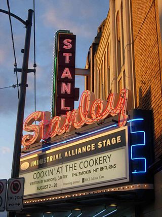
The Stanley Industrial Alliance Stage is a landmark theatre at 12th Avenue and Granville Street in Vancouver, British Columbia, which serves as the main stage for the Arts Club Theatre Company. The Stanley first opened as a movie theatre in December 1930 and showed movies for over sixty years before falling revenues led to its closure in 1991. After years of threatened commercial redevelopment, the Stanley was renovated as a stage theatre between 1997 and 1998 and subsequently awarded status as a heritage building.
KWDF is a daytime only radio station broadcasting a Christian format. Licensed to Ball, Louisiana, United States, and serving the Alexandria, Louisiana area, the station is owned by Capital City Radio Corporation.

State Palace Theatre is a performing arts venue located in downtown New Orleans, Louisiana. It is located at the uptown lake corner of Canal Street and Rampart Street. The Saenger Theater is directly opposite the State Palace on Canal Street.

The Federal Correctional Institution, Oakdale is a low-security United States federal prison for male inmates in Louisiana. It is part of the Oakdale Federal Correctional Complex (FCC) and operated by the Federal Bureau of Prisons, a division of the United States Department of Justice.
Kolin is an unincorporated community in Rapides Parish, Louisiana United States and is part of the Alexandria metropolitan area, Louisiana. Along with the nearby town of Libuse, it was founded in 1914 by Czech immigrants, and named after Kolín, Czech Republic.
References
- ↑ "Hearn Stage at The Kress Theatre". louisiana-arts.org. Archived from the original on 2012-11-25. Retrieved 2015-05-31.
- ↑ "Hearn Stage at The Kress Theatre". cityofalexandriala.com. Retrieved 2015-05-31.