Cape Town is one of South Africa's three capital cities, serving as the seat of the Parliament of South Africa. It is the legislative capital of the country, the oldest city in the country, and the second largest. Colloquially named the Mother City, it is the largest city of the Western Cape province, and is managed by the City of Cape Town metropolitan municipality. The other two capitals are Pretoria, the executive capital, located in Gauteng, where the Presidency is based, and Bloemfontein, the judicial capital in the Free State, where the Supreme Court of Appeal is located.

The Catskill Mountains, also known as the Catskills, are a physiographic province of the larger Appalachian Mountains, located in southeastern New York. As a cultural and geographic region, the Catskills are generally defined as those areas close to or within the borders of the Catskill Park, a 700,000-acre (2,800 km2) forest preserve protected from many forms of development under New York state law.
Blue Mountain may refer to:

Strand is a seaside resort town in the Western Cape, South Africa. It forms part of the Helderberg region of the City of Cape Town Metropolitan Municipality, situated on the north-eastern edge of False Bay and near the foot of the Helderberg Mountains. Its geographical position is between Somerset West and Gordon's Bay, and is about 50 km southeast of Cape Town City Bowl. Strand has a population of approximately 50,000. Strand's main attraction is the beach; 5 km of white sandy beach off False Bay.

Verplanck Colvin was a lawyer, author, illustrator and topographical engineer whose understanding and appreciation for the environment of the Adirondack Mountains led to the creation of New York's Forest Preserve and the Adirondack Park.

John Boyd Thacher State Park is a state park located 15 miles (24 km) southwest of Albany, New York, near Voorheesville, in Albany County on State Route 157. Located mostly atop the Helderberg Escarpment, the park has several hiking trails that offer panoramic views of the Green Mountains in Vermont and the Taconic Mountains of the Hudson Valley.

Somerset West is a town in the Western Cape, South Africa. Organisationally and administratively it is included in the City of Cape Town metropolitan municipality as a suburb of the Helderberg region . The vehicle registration code for Somerset West is CFM and the post code is 7130 for street addresses, and 7129 for post office boxes.
Trout Pond — formerly called Old Pond — located near Wardensville in Hardy County, West Virginia, USA, is the state's only natural lake. The small "lake" is situated in the Trout Pond Recreation Area (TPRA) of the George Washington National Forest. Formerly, the pond had fluctuated in surface area between 2 and 3 acres, but recently it has appeared to be disappearing due to underground structural changes.

Gordon's Bay is a harbour town in the Western Cape province of South Africa. It is included in the City of Cape Town metropolitan municipality as a suburb of the Helderberg region. It is situated on the shores of Gordon's Bay in the northeastern corner of False Bay about 58 km from Cape Town to the south of the N2 national road and is named after Robert Jacob Gordon (1743–1795), the Dutch explorer of Scottish descent.

Helderberg refers to a planning district of the City of Cape Town metropolitan municipality, the mountain after which it is named, a wine-producing area in the Western Cape province of South Africa, or a small census area in Somerset West.

The Devonian Old Port Formation is a mapped bedrock unit in Pennsylvania, USA. Details of the type section and of stratigraphic nomenclature for this unit as used by the U.S. Geological Survey are available on-line at the National Geologic Map Database. Current nomenclature usage by U.S. Geological Survey restricts the name Old Port Formation to Pennsylvania, but correlative units are present in adjacent states.

Cape Town lies at the south-western corner of the continent of Africa. It is bounded to the south and west by the Atlantic Ocean, and to the north and east by various other municipalities in the Western Cape province of South Africa.

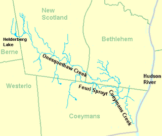
Coeymans Creek is a 7.3-mile-long (11.7 km) tributary of the Hudson River in Albany County, New York in the United States.
The Helderberg Escarpment, also known as the Helderberg Mountains, is an escarpment in eastern New York, United States, roughly 11 miles (18 km) west of the city of Albany. The escarpment is the northeastern extremity of the Allegheny Plateau. It rises steeply from the Hudson Valley below, with an elevation difference of approximately 700 feet over a horizontal distance of approximately 2,000 feet. Much of the escarpment is within John Boyd Thacher State Park, and has views of the Hudson Valley and the Capital District.

Silwerboomkloof Natural Heritage Site is a small, protected valley (“kloof”), near the Helderberg Nature Reserve, in Somerset West, South Africa.
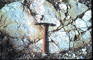
The Ridgeley sandstone is a sandstone or quartzite of Devonian age found in the Appalachian Mountains of Pennsylvania, Maryland, West Virginia, and Virginia, United States. The Ridgeley is fine-grained, siliceous, calcareous in its lower strata, sometimes fossiliferous, and sometimes locally pebbly or conglomeritic. Varying in thickness from 12 to 500 feet, this rock slowly erodes into white quartz sand that often washes or blows away, but sometimes accumulates at large outcrops. When freshly broken, the rock is white, but outcrop surfaces are often stained yellowish by iron oxides.

The Becraft Formation is a geologic formation of marine sedimentary rock found in New York State. The Becraft is a part of the lower Devonian Helderberg Group and conformably overlies the New Scotland Formation and is overlain by the Alsen Formation throughout the lower Hudson Valley of New York State. The formation is Gedinnian in age. Outcrops of the formation are found from the New York-New Jersey border to the Helderbergs of Albany County, New York and as far west as Schoharie County, New York. The thickness of the formation varies from around 3 meters in Canajoharie to 8 meters thick in Albany and swells to 27 meters near Kingston. The Becraft Formation is named for Becraft Mountain in western Columbia County, New York where it prominently crops out.

Nescopeck Mountain is a ridge in Columbia County and Luzerne County, in Pennsylvania, in the United States. Its elevation is 1,594 feet (486 m) above sea level. The ridge is a forested ridge, with at least two types of forest and two systems of vernal pools. It is a very long and unbroken ridge with two water gaps: one carved by Catawissa Creek and one carved by Nescopeck Creek. This later gap was exploited as a transportation corridor with the construction of the Lausanne–Nescopeck Turnpike between the respective frontier communities at Lausanne Landing and Nescopeck in 1805 connecting the newly developing Wyoming Valley with Philadelphia and the Delaware River valley; cutting off over 100 miles between Philadelphia and Wilkes-Barre. Today's Route PA 93 derives from this historic pack mule road.

The Upper Hudson AVA is an American Viticultural Area located to the north and west of Albany, New York. It is approximately 1650 square miles with nearly 65 acres of vines planted and 19 vineyards. It includes parts or all of seven counties in upstate New York, specifically Albany, Montgomery, Rensselaer, Saratoga, Schenectady, Schoharie and Washington.


