
Vaksdal (help·info) is a municipality in the county of Hordaland, Norway. It is located in the traditional district of Nordhordland. The administrative centre is the village of Dalekvam. Other villages in Vaksdal include Dalegarden, Flatkvål, Helle, Nesheim, Stamneshella, Stanghelle, and Vaksdal.

Haram is a municipality in Møre og Romsdal county, Norway. It is part of the Sunnmøre region. The administrative center is Brattvåg, the industrial center of Sunnmøre. Other important villages in the municipality include Austnes, Eidsvik, Helle, Longva, Hildrestranda, Søvik, Tennfjord, and Vatne.
Helle is a village in the Kragerø municipality of Telemark, Norway, located on the north shores of Hellefjorden about 7 km (4.3 mi) northeast of the city of Kragerø.

Nedstrand is a village in Tysvær municipality in Rogaland county, Norway. The village is located on the southeastern coast of the Nedstrand peninsula, at the confluence of the Nedstrandsfjorden and Vindafjorden. The village of Hindaråvåg lies just west of Nedstrand, and Nedstrand Church is located there. The 0.32-square-kilometre (79-acre) village of Nedstrand has a population (2014) of 240, giving the village a population density of 750 inhabitants per square kilometre (1,900/sq mi).

Konsmo is the administrative centre of Audnedal municipality in Vest-Agder county, Norway. The village is located south of the lake Ytre Øydnavatnet along the Audna river in the Audnedalen valley. The Konsmo Church is located in the village. The small village of Helle is located just 1 kilometre (0.62 mi) north of Konsmo. The village was also the administrative centre of the old municipality of Konsmo which existed from 1911 until 1964.
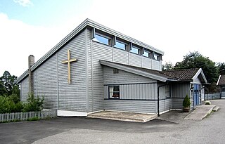
Helle is a village in Vaksdal municipality, Hordaland, Norway. Located northeast of Stanghelle, Helle is included in the urban area Stanghelle which has a population of 763.

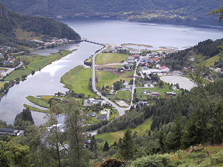
Stanghelle is a village in Vaksdal municipality in Hordaland county, Norway. The village lies along the Veafjorden at the mouth of the Hellestraumen. The 0.4-square-kilometre (99-acre) village has a population (2013) of 783, giving the village a population density of 1,958 inhabitants per square kilometre (5,070/sq mi).
Knut Helle was a Norwegian historian. A professor at the University of Bergen from 1973 to 2000, he specialized in the late medieval history of Norway. He has contributed to several large works.

Helle or Hella is a village in Naustdal Municipality in Sogn og Fjordane county, Norway. It is located on the north side of the Førdefjorden, about 9 kilometres (5.6 mi) southeast of the village of Indrevevring and about 10 kilometres (6.2 mi) southwest of the municipal center of Naustdal. The population of Helle (2001) was 133.

Norwegian county road 407 is a Norwegian county road in Aust-Agder county, Norway. The 13.9-kilometre (8.6 mi) highway runs between the village of Vik in Grimstad municipality and Sponvika on the south side of the city of Arendal in Arendal municipality. Prior to the transportation reforms of 2010, this road was a Norwegian national road, but since then it was taken over by the county.
The Schei Committee was a committee named by the Government of Norway to look into the organization of municipalities in Norway post-World War II.
Bøvågen is a small village in Radøy municipality, Hordaland county, Norway. It's located on the northern part of the island of Radøy. From 1924 until 1964, it was the administrative centre of the former municipality of Hordabø. Hordabø Church is located in the village.
Events in the year 1779 in Norway.
Events in the year 1610 in Norway.
Naustdal is the administrative centre of Naustdal Municipality in Sogn og Fjordane county, Norway. The village is located on the northern shore of the Førdefjorden at the mouth of the river Nausta, which flows through the Naustdalen valley. The village sits about 12 kilometres (7.5 mi) northwest of the town of Førde and about 10 kilometres (6.2 mi) northeast of the village of Helle. Kletten Hill rises southeast of the village.
Indrevevring is a village in Naustdal Municipality in Sogn og Fjordane county, Norway. The village is located on the northern shore of the Førdefjorden, about 20 kilometres (12 mi) southeast of the village of Stavang and about 10 kilometres (6.2 mi) northwest of the village of Helle. The village of Kvammen lies directly south, across the fjord. The village of Indrevevring had a population (2001) of 143 residents.
Holmedal is a village in Askvoll Municipality in Sogn og Fjordane county, Norway. The village is located on the northern shore of the Dalsfjorden, about 7 kilometres (4.3 mi) east of the village of Askvoll. The village was a part of Fjaler municipality before 1990 when it was administratively transferred to Askvoll municipality. The village has some industries, such as knife factory, Helle Fabrikker. Holmedal Church is also located here.

Søndeled is a village in Risør municipality in Aust-Agder county, Norway. The village is located at the western end of the Søndeledfjorden at the mouth of the river Brøbøvann. The villages of Fiane and Eikeland lie about 5 kilometres (3.1 mi) to the north, the village of Akland lies about 4.5 kilometres (2.8 mi) to the south, and the town of Risør is about 15 kilometres (9.3 mi) to the southeast.


