Lake County is a suburban county of Chicago, situated in the northeastern corner of the U.S. state of Illinois along the shores of Lake Michigan. According to the 2010 census, it has a population of 703,462, making it the third-most populous county in Illinois after nearby Cook and DuPage Counties. Its county seat is Waukegan, the ninth-largest city in Illinois. Due to its location, immediately north of Cook County, Lake County is one of the collar counties of the Chicago metropolitan area.

Lake Forest is a city located in Lake County, Illinois, United States. As of the 2010 census it had a population of 19,375. The city is along the shore of Lake Michigan, and is a part of the Chicago metropolitan area and the North Shore.

Forest Lake is a city in Washington County, Minnesota, United States. It is 27 miles northeast of Saint Paul. The population was 18,375 at the 2010 census. The 2019 population is 20,933.

The Chequamegon–Nicolet National Forest is a 1,530,647-acre (6,194.31 km2) U.S. National Forest in northern Wisconsin in the United States. Due to logging in the early part of the 20th century, very little old growth forest remains. Some of the trees that grow there today were planted by the Civilian Conservation Corps in the 1930s. The national forest lands contain trees and vegetation corresponding to the North Woods Ecoregion that is prevalent throughout the upper Great Lakes region.

Gifford Pinchot National Forest is a National Forest located in southern Washington, USA, managed by the United States Forest Service. With an area of 1.32 million acres (5300 km2), it extends 116 km along the western slopes of Cascade Range from Mount Rainier National Park to the Columbia River. The forest straddles the crest of the South Cascades of Washington State, spread out over broad, old growth forests, high mountain meadows, several glaciers, and numerous volcanic peaks. The forest's highest point is at 12,276 ft. at the top of Mount Adams, the second tallest volcano in the state after Rainier. Often found abbreviated GPNF on maps and in texts, it includes the 110,000-acre (450 km2) Mount St. Helens National Volcanic Monument, established by Congress in 1982.

The Apache–Sitgreaves National Forests are two 2.76-million-acre (11,169 km2) United States National Forests which run along the Mogollon Rim and the White Mountains in east-central Arizona and into the U.S. state of New Mexico. Both forests are managed as one unit by USDA Forest Service from the forests Supervisors Office in Springerville, Arizona. Apache–Sitgreaves has over 400 species of wildlife. With its high elevation and cool summer breezes it is a popular weekend destination from the hot desert for Phoenix, Arizona, residents. The forest is divided into 5 Ranger Districts that span almost 300 miles (480 km) from Clifton, Arizona in the east-central portion of Arizona to the eastern boundary of the Coconino National Forest in north-central Arizona. The Apache–Sitgreaves National Forest borders the western and northern borders of the Fort Apache Indian Reservation. It is located in parts of Greenlee, Apache, Navajo, and Coconino counties in eastern and east-central Arizona, and Catron County in western New Mexico. The more northwesterly Sitgreaves National Forest portion lies adjacent to the north side of the Fort Apache Indian Reservation and is located entirely in Arizona, within Navajo, Apache, and Coconino counties. It has a total area of 818,651 acres (3,313 km2). The more southeasterly and much larger Apache National Forest portion lies adjacent to the east side of the Fort Apache and the San Carlos Indian Reservations. It lies on both sides of the border with New Mexico, in Greenlee, Catron, and Apache counties. It has a total area of 1,813,601 acres (7,339 km2).

The Hoover Wilderness is a wilderness area in the Inyo and Humboldt-Toiyabe National Forests. It lies to the east of the crest of the central Sierra Nevada in California, to the north and east of Yosemite National Park - a long strip stretching nearly to Sonora Pass on the north and Tioga Pass on the south.

The Ocala National Forest ls the second largest nationally protected forest in the U.S. State of Florida. It covers 607 square miles (1,570 km2) of Central Florida. It is located three miles (5 km) east of Ocala and 16 miles (26 km) southeast of Gainesville. The Ocala National Forest, established in 1908, is the oldest national forest east of the Mississippi River and the southernmost national forest in the continental U.S. The word Ocala is thought to be a derivative of a Timucuan term meaning "fair land" or "big hammock". The forest is headquartered in Tallahassee, as are all three National Forests in Florida, but there are local ranger district offices located in Silver Springs and Umatilla.
The Henry M. Jackson Wilderness is a 103,297-acre (41,803 ha) designated wilderness area in the state of Washington, United States. The area lies adjacent to the southwest corner of the Glacier Peak Wilderness, northwest of Stevens Pass on U.S. Highway 2 and northeast of the town of Skykomish, Washington. Wild Sky Wilderness is located immediately southwest of the Henry M. Jackson Wilderness. While the wilderness straddles the Cascade Mountain Range, most of it is in the westside ecotype. The wilderness lies in parts of Snoqualmie, Mount Baker, and Wenatchee national forests.

Inyo National Forest is a United States National Forest covering parts of the eastern Sierra Nevada of California and the White Mountains of California and Nevada. The forest hosts several superlatives, including Mount Whitney, the highest point in the contiguous United States; Boundary Peak, highest point in Nevada; and the Ancient Bristlecone Pine Forest that protects the oldest trees in the world. The forest, encompassing much of Owens Valley, was established by Theodore Roosevelt as a way of sectioning off land to accommodate the Los Angeles Aqueduct project in 1907, making the Inyo National Forest one of the least wooded forests in the United States' system.

The Shasta–Trinity National Forests are federally designated forests in northern California, United States. Combined, they are the largest National Forest in California and are managed by the U.S. Forest Service. The 2,210,485 acre combined-forest encompasses five wilderness areas, hundreds of mountain lakes and 6,278 miles (10,103 km) of streams and rivers. Major features include Shasta Lake, the largest man-made lake in California and Mount Shasta, elevation 14,179 feet (4,322 m).

The Alpine Lakes Wilderness is a large wilderness area spanning the Central Cascades of Washington state in the United States. The wilderness is located in parts of Wenatchee National Forest and Snoqualmie National Forest, and is approximately bounded by Interstate 90 and Snoqualmie Pass to the south and U.S. Route 2 and Stevens Pass to the north. The Alpine Lakes is the largest wilderness area near the population centers of Puget Sound, counted at 414,161 acres (167,605 ha) following the 2014 expansion.

Wasatch–Cache National Forest is a United States National Forest located primarily in northern Utah (81.23%), with smaller parts extending into southeastern Idaho (16.42%) and southwestern Wyoming (2.35%). The name is derived from the Ute word Wasatch for a low place in high mountains, and the French word Cache meaning to hide. The term cache originally referred to fur trappers, the first Europeans to visit the land. The Wasatch–Cache National Forest boundaries include 1,607,177 acres (6,504.01 km2) of land.

Lake Forest College is a private liberal arts college in Lake Forest, Illinois. Founded in 1857 as Lind University by a group of Presbyterian ministers, the college has been coeducational since 1876 and an undergraduate-focused liberal arts institution since 1903. Lake Forest enrolls approximately 1,600 students representing 47 states and 81 countries. Lake Forest offers 30 undergraduate major and minor programs in the humanities, social sciences, and natural sciences, and features programs of study in pre-law, pre-medicine, communication, business, finance, and computer science. The majority of students live on the college's wooded 107-acre campus located a half-mile from the Lake Michigan shore.

Eagle Cap Wilderness is a wilderness area located in the Wallowa Mountains of northeastern Oregon, within the Wallowa–Whitman National Forest. The wilderness was established in 1940. In 1964, it was included in the National Wilderness Preservation System. A boundary revision in 1972 added 73,000 acres (30,000 ha) and the Wilderness Act of 1984 added 66,100 acres (26,700 ha) resulting in a current total of 361,446 acres, making Eagle Cap by far Oregon's largest wilderness area.
Sun Pass State Forest is one of six state forests managed by the Oregon Department of Forestry. The forest is located 40 miles (64 km) north of Klamath Falls, Oregon near the southeastern corner of Crater Lake National Park. It is the largest single block of Oregon state forestry land east of the Cascade Mountains. The forest is managed as part of the Klamath-Lake District, comprising 21,317 acres (86.27 km2) of the 33,739 state-owned acres within the district.

The Franco-German Palatinate Forest-North Vosges Biosphere Reserve was created in 1998 as the first UNESCO trans-boundary biosphere reserve in Europe. The German part became the 12th of 16 biosphere reserves in Germany and the French one the 6th of 14 in France.
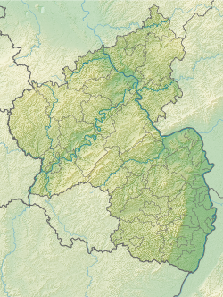
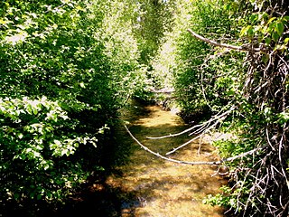
The Blattbach is a tributary of the Helmbach, roughly 3 kilometres (2 mi) long, in the Palatinate Forest in the German state of Rhineland-Palatinate. It rises in the central part of the forest and flows eastwards before discharging into the Helmbach. The Blattbach is located entirely within the territory of the municipality of Elmstein.