
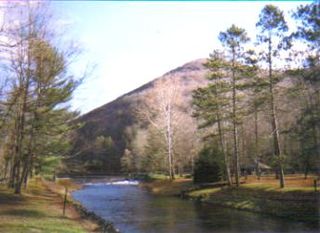
The Hoosier National Forest is a property managed by the United States Forest Service in the hills of southern Indiana. Composed of four separate sections, it has a total area of 204,303 acres. Hoosier National Forest's headquarters are located in Bedford, with a regional office in Tell City. Prominent places within the Forest include the Lick Creek Settlement, Potts Creek Rockshelter Archeological Site, and Jacob Rickenbaugh House.

The Three Sisters Wilderness is a wilderness area in the Cascade Range, within the Willamette and Deschutes National Forests in Oregon, United States. It comprises 286,708 acres (1,160.27 km2), making it the second largest wilderness area in Oregon, after the Eagle Cap Wilderness. It was established by the United States Congress in 1964 and is named for the Three Sisters volcanoes. The wilderness boundary encloses the Three Sisters as well as Broken Top, which is southeast of South Sister.

Honeoye Creek is a tributary of the Genesee River in western New York in the United States. The name Honeoye is from the Seneca word ha-ne-a-yah, which translates to "lying finger", or "where the finger lies". The name refers to the local story of a Native American who had his finger bitten by a rattlesnake and therefore cut off his finger with a tomahawk.

Wawayanda State Park is a 34,350 acres (139.0 km2) state park in Sussex County and Passaic County in northern New Jersey. The park is in Vernon Township on the Sussex side, and West Milford on the Passaic side. There are 60 miles (97 km) of hiking trails in the park, including a 20 miles (32 km) stretch of the Appalachian Trail. The park is operated and maintained by the New Jersey Division of Parks and Forestry. The hiking trails are maintained and updated by the New York - New Jersey Trail Conference.
Yard Creek Provincial Park is a provincial park located 15 kilometres east of Sicamous along the Trans-Canada Highway in British Columbia, Canada.
Kettle Creek is a tributary of the West Branch Susquehanna River running through Tioga, Potter, and Clinton counties, in Pennsylvania. It is slightly less than 43 miles (69 km) long. Although many streams in the Kettle Creek watershed are considered "Class A Wild Trout streams" by the Pennsylvania Fish and Boat Commission, the lower reaches of the stream experience acid mine drainage. The upper reaches of the creek are considered to be very high-quality.
Fishing Creek is a 29.98-mile (48.25 km) long tributary of the Susquehanna River in Columbia County, Pennsylvania, in the United States. It joins the Susquehanna River near the census-designated place of Rupert and the town of Bloomsburg. The watershed has an area of 385 square miles (1,000 km2).

Salt Springs State Park is a Pennsylvania state park in Franklin Township, Susquehanna County, Pennsylvania, in the United States. The park is home to massive hemlock trees that are over 500 years old and are among the largest trees in all of Pennsylvania. The Fall Brook Natural Area within the park is recognized as a part of the Old-Growth Forest Network. The park also features a gorge with three waterfalls on Fall Brook. Salt Springs State Park is 7 miles (11 km) north of Montrose, just off Pennsylvania Route 29. The park is the only state park in Pennsylvania that is managed by a non-profit organization, the Friends of Salt Springs Park. The state owns 405 acres (164 ha) of land and the Friends own an additional 437 acres (177 ha) bringing the total amount of protected land to 842 acres (341 ha).

Little Fishing Creek is a tributary of Fishing Creek in Sullivan County, Lycoming County, and Columbia County, in Pennsylvania, in the United States. It is approximately 23.5 miles (37.8 km) long and flows through eight townships. The watershed of the creek has an area of 68.1 square miles (176 km2). The creek has six named tributaries, of which the largest are Spruce Run and West Branch Run.

Little Butte Creek is a 17-mile-long (27 km) tributary of the Rogue River in the U.S. state of Oregon. Its drainage basin consists of approximately 354 square miles (917 km2) of Jackson County and another 19 square miles (49 km2) of Klamath County. Its two forks, the North Fork and the South Fork, both begin high in the Cascade Range near Mount McLoughlin and Brown Mountain. They both flow generally west until they meet near Lake Creek. The main stem continues west, flowing through the communities of Brownsboro, Eagle Point, and White City, before finally emptying into the Rogue River about 3 miles (5 km) southwest of Eagle Point.

Onondaga Creek is a major tributary of Onondaga Lake which is located in Onondaga County, New York. The headwaters of the creek originate 27 miles (43 km) south of the city of Syracuse near the hamlet of Vesper, in the town of Tully, New York. The creek flows north through the Tully Valley and through the city of Syracuse where it empties into Onondaga Lake.
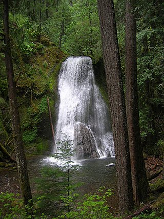
Yakso Falls is a 70-foot (21 m) waterfall on Little River, in the Cascade Range east of Roseburg in the U.S. state of Oregon. The waterfall is about 27 miles (43 km) from the unincorporated community of Glide along Little River Road, which becomes Forest Road 27.

The Juneau gold belt is located in the southeastern portion of the U.S. state of Alaska. This belt is approximately 100 miles (160 km) in length, north/northwest-trending, and extends from Berners Bay southeastward to Windham Bay, 60 miles (97 km) southeast of Juneau, and includes Douglas Island. The belt contains over 200 gold-quartz-vein deposits with production nearing 7,000,000 ounces (200,000,000 g) of gold. More than three-quarters of Alaska's lode gold was mined from the Juneau gold belt.

South Branch Roaring Creek is a tributary of Roaring Creek in Columbia County and Northumberland County, Pennsylvania, in the United States. It is approximately 16.8 miles (27.0 km) long. The upper reaches of the creek are located in Weiser State Forest, between Big Mountain and Little Mountain. The creek is home to some trout and is considered a high-quality coldwater fishery. The Chemung Formation occurs in the creek's watershed. The watershed is 25 square miles in area.
Hemlock Creek is a stream in Columbia County, Pennsylvania, in the United States. It is 7.6 miles (12.2 km) in length. The stream is a tributary of Fishing Creek. It is primarily in Madison and Hemlock Townships. Its named tributaries are West Hemlock Creek and Frozen Run. Hemlock Creek flows through Montour Ridge. Industries in the vicinity of Hemlock Creek have largely consisted of mills and iron mines. The creek's watershed is in Columbia and Montour Counties and is 16 square miles (41 km2) in area.
Wallace Run is a tributary of Bald Eagle Creek in Centre County, Pennsylvania, in the United States. It is 12.1 miles (19.5 km) long and is a low-alkalinity stream. The stream flows through Union Township and Boggs Township in Centre County. Most of the watershed is in Boggs Township. The North Branch of Wallace Run is one tributary of the stream. The watershed has an area of 24 square miles (62 km2). Oaks, maples, ash trees, birches, hemlocks, and rhododendrons all exist in the upper reaches of the stream, which is mostly forested. The lower reaches of the stream are mostly developed.

Stony Brook is a tributary of Fishing Creek in Columbia County, Pennsylvania. It is 4.3 miles (6.9 km) long and flows through North Centre Township and Orange Township. The stream's watershed has an area of 3.72 square miles. It flows through a steep ravine which is inhabited by numerous plant species for much of its length. The fossil-rich Stony Brook Beds also have an outcropping near the stream. In the 1870s, it was considered for use as a water supply by the Bloomsburg Water Company.
Little Shickshinny Creek is a tributary of Shickshinny Creek in Columbia County and Luzerne County, in Pennsylvania, United States. It is 9.5 miles (15.3 km), nearly as long as Shickshinny Creek itself. The creek flows through Briar Creek Township, Columbia County; Salem Township, Luzerne County; and the borough of Shickshinny, in Luzerne County. It is designated as a high-quality coldwater fishery. Pennsylvania State Game Lands #55 and #260 are in the creek's watershed. The watershed has an area of 9.8 square miles, which includes swamps and forests. Waterfalls known as the Little Shickshinny Creek Falls are located on the creek.
