
Blue Gene was an IBM project aimed at designing supercomputers that can reach operating speeds in the petaFLOPS (PFLOPS) range, with low power consumption.
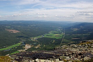
Hemsedal is a municipality in Buskerud county, Norway. It is part of the traditional region of Hallingdal. The administrative centre of the municipality is the village of Trøym. Hemsedal lies on the Norwegian National Road 52. Hemsedal is located 220 km (136.70 mi) northwest of Oslo and 273 km (169.63 mi) from Bergen. In 1897, Hemsedal was separated from the municipality of Gol to become a municipality of its own.

A hexomino is a polyomino of order 6; that is, a polygon in the plane made of 6 equal-sized squares connected edge to edge. The name of this type of figure is formed with the prefix hex(a)-. When rotations and reflections are not considered to be distinct shapes, there are 35 different free hexominoes. When reflections are considered distinct, there are 60 one-sided hexominoes. When rotations are also considered distinct, there are 216 fixed hexominoes.

A color term is a word or phrase that refers to a specific color. The color term may refer to human perception of that color which is usually defined according to the Munsell color system, or to an underlying physical property. There are also numerical systems of color specification, referred to as color spaces.

The Green Mountains are a mountain range in the U.S. state of Vermont and are a subrange of the Appalachian Mountains. The range runs primarily south to north and extends approximately 250 miles (400 km) from the border with Massachusetts to the border with Quebec, Canada. The part of the same range that is in Massachusetts and Connecticut is known as The Berkshires or the Berkshire Hills and the Quebec portion is called the Sutton Mountains, or Monts Sutton in French.

Mount Blue Sky is the highest peak in the Mount Evans Wilderness in the Front Range of the Rocky Mountains of North America. The prominent 14,271-foot (4,350 m) fourteener is located 13.4 miles (21.6 km) southwest by south of Idaho Springs in Clear Creek County, Colorado, United States, on the drainage divide between Arapaho National Forest and Pike National Forest.

The Three Sisters are a trio of peaks near Canmore, Alberta, Canada. They are known individually as Big Sister, Middle Sister and Little Sister.
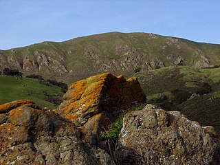
Mission Peak is a mountain peak located east of Fremont, California. It is the northern summit on a ridge that includes Mount Allison and Monument Peak. Mission Peak has symbolic importance, and is depicted on the logo of the City of Fremont. It is located in Mission Peak Regional Preserve, a regional park operated by the East Bay Regional Park District.

The Bull of the Woods Wilderness is a wilderness area located in the Mount Hood National Forest in the northwestern Cascades of Oregon, United States. It was created in 1984 and consists of 37,607 acres (15,219 ha) including prime low-elevation old-growth forest, about a dozen lakes of at least 1-acre (4,000 m2) and many large creeks and streams. Adjacent areas, including Opal Creek Wilderness to the west, create a pristine area of nearly 84 square miles (218 km2). There are seven trails that access the wilderness area with an additional seven trails within the protection boundaries themselves. Combined the system provides 75 miles (121 km) of challenging terrain for both pedestrian and equestrian recreation. The name of the peak and thus the wilderness area comes from logging jargon in which the "bull of the woods" was the most experienced logging foreman in an operation.
The Appalachian National Scenic Trail spans 14 U.S. states over its roughly 2,200 miles (3,500 km): Georgia, North Carolina, Tennessee, Virginia, West Virginia, Maryland, Pennsylvania, New Jersey, New York, Connecticut, Massachusetts, Vermont, New Hampshire, and Maine. The southern end is at Springer Mountain, Georgia, and it follows the ridgeline of the Appalachian Mountains, crossing many of its highest peaks and running almost continuously through wilderness before reaching the northern end at Mount Katahdin, Maine.

Breckenridge Ski Resort is an alpine ski resort in the western United States, in Breckenridge, Colorado. Recognized for acres of skiable terrain across five mountain peaks, it welcomes thousands of skiers and snowboarders each season. Just west of the Continental Divide in Summit County, it is perennially one of the most visited ski resorts in the western hemisphere. Breckenridge is owned and operated by Vail Resorts, Inc.

The Art Loeb Trail is a 30.1-mile (48.4 km) hiking trail located in Pisgah National Forest in Western North Carolina. The northern terminus is at the Daniel Boone Boy Scout Camp in Haywood County, while the trail's southern terminus is located near the Davidson River Campground, near Brevard, in Transylvania County. Along the way, the trail traverses several significant peaks, including Black Balsam Knob (6,214 ft), Tennent Mountain (6040 ft) and Pilot Mountain (5095 ft). The trail also passes the base of Cold Mountain, made famous by the novel and film. Cold mountain is a must for any art loeb thru hiker/runner and only adds around 700ft in elevation. National Geographic Adventure listed the trail as one of the thirty best North American hikes. They praised the views offered on the high Appalachian Balds, the challenging climbs, and the trail's diverse landscape.
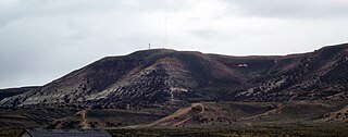
Wilkins Peak is a small mountain located in Sweetwater County, Wyoming, between the cities of Green River and Rock Springs. It is primarily used for radio and television station transmitters, but it also serves radio needs of the FAA, EMS, and local businesses such as Questar Gas. In 2003, a tower on the peak was knocked down by a vehicle delivering propane to customers. The tower was owned by Wyoming Public Radio and was serving the local area with programming from National Public Radio. There are numerous access roads to the peak and it is not gated and open year-round, weather permitting. Along with the radio uses, the mountain is also a popular location for mountain biking and hiking. The mountain contains geology typical of its location in southwestern Wyoming.
White Mountain is a long mountain located in central Sweetwater County, Wyoming, near the cities of Rock Springs and Green River. The mountain is part of the Green River Formation, and contains communications towers that serve a number of purposes. Hundreds of carved figures also dot the sandstone cliffs at the White Mountain Petroglyph site and range from 200 to 1000 years old. Pilot Butte, located on top of White Mountain, is accessible from roads on the mountain.

Rjukandefossen is a double waterfall of approximately 18 metres located in the vicinity of the village Tuv in the municipality of Hemsedal in Buskerud, Norway.

Totten is a mountain located in the Hemsedal municipality in Norway. It is a part of Hemsedal Top 20. Some of the hike to the peak can be done by travelling with one of Hemsedal's many ski lifts.

The Huachuca Mountains are part of the Sierra Vista Ranger District of the Coronado National Forest in Cochise County in southeastern Arizona, approximately 70 miles (110 km) south-southeast of Tucson and southwest of the city of Sierra Vista. Included in this area is the highest peak in the Huachucas, Miller Peak, and the region of the Huachucas known as Canelo Hills in eastern Santa Cruz County. The mountains range in elevation from 3,934 feet (1,199 m) at the base to 9,466 feet (2,885 m) at the top of Miller Peak. The second highest peak in this range is Carr Peak, elevation 9,200 feet (2,804 m). The Huachuca Mountain area is managed principally by the United States Forest Service (41%) and the U.S. Army (20%), with much of the rest being private land (32%). Sierra Vista is the main population center.
Hughes Mountain and the Hughes Mountain State Natural Area are located in southern Washington County, Missouri just south of the Big River and Highway M on Cedar Creek Road in the St. Francois Mountains range of The Ozarks. The mountain reaches an elevation of just over 1,200 feet, rising 430 feet above the Big River. The Hughes Mountain Natural Area of the Missouri Department of Conservation encompasses 462 acres (1.87 km2) of the mountain, including the rhyolite glade at its top.
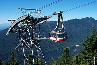
Grouse Mountain is one of the North Shore Mountains of the Pacific Ranges in the District Municipality of North Vancouver, British Columbia, Canada. With a maximum elevation of over 1,200m (4,100ft) at its peak, the mountain is the site of an alpine ski area, Grouse Mountain Resort, which overlooks Metro Vancouver and has four chairlifts servicing 33 runs. In the summer, Grouse Mountain Resort features lumberjack shows, the "Birds in Motion" birds of prey demonstration, a chairlift ride, disc golf, mountain biking, zip lining, tandem paragliding, helicopter tours, and guided ecowalks. Year-round operations include a 100-seat mountaintop theatre and a wildlife refuge. The mountain operates two aerial tramways, known officially as the Skyride. The Blue Skyride is used mainly for freight transportation, while public access to the mountain top is provided by the Swiss-built Garaventa Red Skyride, which has a maximum capacity of 101 passengers. Summer access is also provided by the 2.9 kilometre Grouse Grind hiking trail, which is open for hiking from May to October. Similar to the nearby Capilano Suspension bridge, Grouse Mountain can be accessed via a free, regular shuttle bus that runs from 'Canada Place' in downtown Vancouver.

Trzy Korony is the summit of the Three Crowns Massif, an independent portion of a range called Pieniny Mountains in the south of Poland. Trzy Korony forms the central part of a compact group of connected mountains known as Pieniny Środkowe, consisting mainly of the limestone and dolomite rock strata. Trzy Korony is located within the Pieniny National Park in Lesser Poland Voivodeship.
