| Hemsedalsfjella | |
|---|---|
 | |
| Geography | |
| Location | Buskerud, Norway |
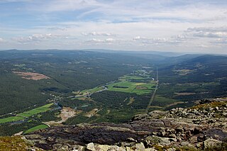
Hemsedalsfjella (English: The Hemsedal mountains) are the mountains that surrounds Hemsedal Valley in Buskerud, Norway. Most of the Hemsedal mountains is in Hemsedal municipality. [1]
| Hemsedalsfjella | |
|---|---|
| | |
| Geography | |
| Location | Buskerud, Norway |
Hemsedalsfjella (English: The Hemsedal mountains) are the mountains that surrounds Hemsedal Valley in Buskerud, Norway. Most of the Hemsedal mountains is in Hemsedal municipality. [1]
Hemsedal is a municipality in Buskerud county, Norway. It is part of the traditional region of Hallingdal. The administrative centre of the municipality is the village of Trøym. Hemsedal lies on the Norwegian National Road 52. Hemsedal is located 220 km (136.70 mi) northwest of Oslo and 273 km (169.63 mi) from Bergen. In 1897, Hemsedal was separated from the municipality of Gol to become a municipality of its own.

Valdres is a traditional district in central, southern Norway, situated between the districts of Gudbrandsdalen and Hallingdal. The region of Valdres consists of the six municipalities of Nord-Aurdal, Sør-Aurdal, Øystre Slidre, Vestre Slidre, Vang and Etnedal. Valdres has about 18,000 inhabitants and is known for its excellent trout fishing and the local dialect. Its main road is E16 and Fylkesveg 51.

European route E16 is the designation of a main west-east road through Northern Ireland, Scotland, Norway and Sweden, from Derry to Gävle, via Belfast, Glasgow, Edinburgh, previously by ferry to Bergen, Voss, through the Gudvanga Tunnel and the Lærdal Tunnel, Lærdal, over Filefjell to Fagernes, Hønefoss, Gardermoen and Kongsvinger. In Sweden, it passes Malung, Falun and ends in Gävle.
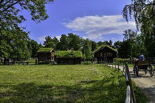
Hemsedal Bygdatun is a small museum in Ulsåk in Hemsedal municipality in Buskerud county, Norway. The museum is a subsidiary of Hallingdal Museum.
Hallingdal Museum Nesbyen is an open-air museum at Nesbyen in Buskerud county, Norway.
Slovak Paradise is a mountain range in eastern Slovakia. It is a part of the Spiš-Gemer Karst, which in turn is a part of the Slovak Ore Mountains, a major subdivision of the Western Carpathians. It is located between the towns of Spišská Nová Ves in the north and Dobšiná in the south. It is particularly known for its gorges and waterfalls. It is very popular with hikers as it has a number of unusual routes through gorges and waterfalls. There are numerous sections where fixed ladders are used to climb. The area is protected by Slovak Paradise National Park.
Gol og Hemsedal is a former municipality in Buskerud county, Norway.

The Ha-Iltzuk Icefield is an icefield in the central Pacific Ranges of the Coast Mountains in British Columbia, Canada. It is the largest icefield in the Coast Mountains south of the Alaska Panhandle, with an area of 3,610 km2 (1,390 sq mi). It is located on the west side of the Klinaklini River and the Waddington Range. The highest summit in the icefield is Mount Silverthrone, which is a mountain on the northeast edge of a circular, 20 km (12 mi) wide, deeply dissected caldera complex called the Silverthrone Caldera.
Svøo is a village in Hemsedal municipality, Norway. It is located in the traditional region of Hallingdal. Svøo is located on the river Hemsil which flows into the Hallingdalselva. Svøo is about five miles from the center of Hemsedal. Its population is 241.
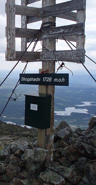
Hemsedal Top 20 is an organisation of twenty mountains in the Hemsedal fell that preferably can be climbed during the summer time. The twenty peaks are each signposted with the name of the peak and the trail leading to the top is marked with either blue-painted stones or a series of cairns. A green box is situated on each peak containing a guest book.

Rjukandefossen is a double waterfall of approximately 18 metres located in the vicinity of the village Tuv in the municipality of Hemsedal in Buskerud, Norway.
Bjørnbakknosi is a hill in Hemsedal in Buskerud Norway. It is located northwest of Grunnane, northeast of Skurvefjellet and south of Veslebotnskarvet.
Haukefjellet is a mountain in southern Norway. Haukefjellet is located on the boundary between Lærdal in Sogn og Fjordane and Hemsedal in Buskerud.
Langebottfjellet is a mountain located in the municipalities of Ål and Hemsedal in Buskerud, Norway.
Leinenosi is a mountain in the municipality of Hemsedal in Buskerud, Norway.
Veslebotnskarvet is a mountain of Hemsedal municipality, Buskerud, in southern Norway.
Niaqornarsuaq is a mountain of Greenland. It is located in the Upernavik Archipelago.

Vinje Glacier is a broad glacier about 20 nautical miles (37 km) long flowing northwest between the Filchner Mountains and Fenriskjeften Mountain in Queen Maud Land. Mapped by Norwegian cartographers from surveys and air photos by the Norwegian Antarctic Expedition (1956–60) and named for T. Vinje, meteorologist with Norwegian Antarctic Expedition (1956–58).
Trøym is a village and the site of the administrative center of Hemsedal municipality in Buskerud county, Norway.
SS George Weems was a Liberty ship built in the United States during World War II. She was named after George Weems, who in 1828, established steamship travel on the Rappahannock River.
60°55′N8°25′E / 60.917°N 8.417°E
| | This article about a mountain, mountain range, or peak in Buskerud is a stub. You can help Wikipedia by expanding it. |