
Washington County is a county located in the southeastern part of the U.S. state of Ohio. As of the 2020 census, the population was 59,711. Its county seat is Marietta. The county, the oldest in the state, is named for George Washington. Washington County comprises the Marietta, OH Micropolitan Statistical Area, which is also included in the Parkersburg-Marietta-Vienna, WV-OH Combined Statistical Area.

Amherstdale-Robinette is a former census-designated place (CDP) in Logan County, West Virginia, United States. The population was 1,785 at the 2000 census. For the 2010 census, the place was split into two CDPs, Amherstdale and Robinette.

The Little Kanawha River is a tributary of the Ohio River, 169 mi (269 km) long, in western West Virginia in the United States. Via the Ohio, it is part of the watershed of the Mississippi River, draining an area of 2,320 mi2 (6,009 km2) on the unglaciated portion of the Allegheny Plateau. It served as an important commercial water route in the early history of West Virginia, particularly in the logging and petroleum industries.

The Marietta–Williamstown Interstate Bridge is a four-lane truss bridge carries Interstate 77 between Williamstown, West Virginia and Marietta, Ohio. The bridge was completed in 1967 and it was rehabilitated in 2003.

The Memorial Bridge, locally known as the toll bridge, crosses the Ohio River connecting Belpre, Ohio and Parkersburg, West Virginia. The bridge is an alternate route to access U.S. Route 50 in Ohio from central Parkersburg. Constructed and formerly owned by the City of Parkersburg, the bridge was purchased in 2022 by Parkersburg Bridge Partners, a private entity that is a subsidiary of Colorado-based United Bridge Partners.

Whipple is an unincorporated community in southern Salem Township, Washington County, Ohio, United States. Although it is unincorporated, it once had a post office, with the ZIP code 45788. It lies on State Route 821 south of the village of Lower Salem, at the junction of Whipple Run with Duck Creek. The community took its name from nearby Whipple Run.

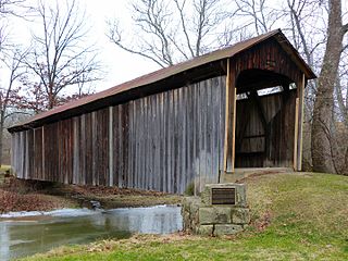
Bartlett is an unincorporated community in southwestern Wesley Township, Washington County, Ohio, United States. It has a post office with the ZIP code 45713. It sits at the intersection of State Routes 550 and 555 near Coal Run, a subsidiary of Wolf Creek, which meets the Muskingum River at Waterford to the north. Near Bartlett is located the Shinn Covered Bridge, which spans Wolf Creek.

Malaga is an unincorporated community in northern Malaga Township, Monroe County, Ohio, United States. Malaga has a ZIP code of 43747. It lies at the intersection of State Routes 145 and 800.

The Hi Carpenter Memorial Bridge is a cantilever bridge over the Ohio River between Newport, Ohio and St. Marys, West Virginia. It carries Ohio State Route 807 and West Virginia Route 807 and serves to connect WV 2 with OH 7.
Dunfield is a local service district and designated place in the Canadian province of Newfoundland and Labrador. It is southwest of Catalina. It had a population of 222 in 1940, 193 in 1951 and 210 in 1956. Renamed in 1913, the present day Dunfield was once the community of Cuckold's Cove.
The 1940 U.S. Open was the 44th U.S. Open, June 6–9 at Canterbury Golf Club in Beachwood, Ohio, a suburb east of Cleveland. Lawson Little defeated Gene Sarazen in an 18-hole playoff to win his only professional major.
Ramazanlı is a village in the Neftchala Rayon of Azerbaijan. The village forms part of the municipality of Qaçaqkənd.
Göyər Abbas is a village in the Qubadli Rayon of Azerbaijan.

The Little Hocking River is a small tributary of the Ohio River, 18.4 miles (29.6 km) long, in southeastern Ohio in the United States. Via the Ohio River, it is part of the watershed of the Mississippi River, draining an area of 102 square miles (260 km2) on the unglaciated portion of the Allegheny Plateau. The river flows for its entire length in southwestern Washington County; its tributaries also drain a small area of southeastern Athens County.
Salt Creek is a stream located entirely within Muskingum County, Ohio.
Bridgeville is an unincorporated community in Muskingum County, in the U.S. state of Ohio.
Cream Ridge is an extinct town in Livingston County, in the U.S. state of Missouri. The GNIS classifies it as a populated place.
The historic bridges at the Lancaster campus of Ohio University were moved to the campus and sit about 100 yards (91 m) apart. The bridges were built in 1881 and 1884–85 very close to each other, both crossing Poplar Creek, and while the first-built is a wood-and-steel covered bridge and the second-built is all-steel, they are similar in design. Original and current locations of both bridges may be seen in OpenStreetMap linked at right.

The Roberts Covered Bridge is a Burr Truss covered bridge in Preble County, Ohio near Eaton. It was built in 1829, and was listed on the National Register of Historic Places in 1971.
